Maps of Všestary

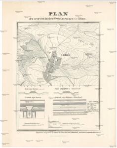
Plan der oesterreichischen Verschanzungen bei Chlum
1 : 6250 Chlum (Všestary, Hradec Králové, Česko) Hohenstädt
Plan der osterreichischen Verschanzungen bei Chlum
1 : 6250 Hohenstädt
Chlum - c2510-1-002 - Kaiserpflichtexemplar der Landkarten des stabilen Katasters
1 : 2880
Chlum - c2510-1-001 - Kaiserpflichtexemplar der Landkarten des stabilen Katasters
1 : 2880
[Gradkartenblatt]
1 : 25000 Hořice-oblast (Jičín, Česko) Vojenský zeměpisný ústav
Schlachtfeld von Königgrätz
1 : 200000 Hradec Králové (Region) Schlacht bei Königgrätz
[Kartenblatt]
1 : 25000 Cerekvice nad Bystřicí (Česko : oblast) Reichsamt für Landesaufnahme
Gradkartenblatt
1 : 25000 Cerekvice nad Bystřicí-oblast (Česko) Böhm, Karl
III. vojenské mapování 3855/4
1 : 25000
Plan des Schlachtfeldes von Königgrätz
1 : 50000 Hradec Králové (Česko : oblast)
Plan des Schlachtfeldes von Königgrätz
1 : 50000
Plan des Schlachtfeldes von Königsgrätz
1 : 25000 Kgl. Preussischer Generalstab
Die Schlacht von Königgrätz
1 : 200000 Hradec Králové (Česko : oblast) F.A. Brockhaus' geogr.-artist. Anstalt
Silniční mapa
1 : 25000

Plan des Schachtfeldes von Königgrätz 3. Juli 1866
1 : 28880 Hradec Králové (Česko) Ditfurth, Moritz von des K. u. k. Militärgeographischen Instituts
Karte des politischen Bezirkes Königinhof

III. vojenské mapování 3855
1 : 75000
Cís. král. komornj panstwj Hořeňowské a Smiřické s připojeným hraběcým Cerekwickým
1 : 200000 Cerekvice nad Bystřicí (Česko) Hanka
Königgrätz u. Umgebung
1 : 75000 Hradec Králové (Česko : oblast) Landesvermessungsamt Böhmen u. Mähren
Hradec Králové a okolí
1 : 75000 Hradec Králové (Česko : oblast) Vojenský zeměpisný ústav
Karte des Schlachtfeldes von Königgrätz
1 : 50000 Gerold
Jičín
1 : 75000 Dvůr Králové nad Labem (Česko : oblast) Vojenský zeměpisný ústav
Operations-Karte für die Schlacht bei Königgrätz
1 : 100000 Hradec Králové-oblast (Česko)
Hořitz und Jičin
1 : 75000 Dvůr Králové nad Labem (Česko : oblast) Richter K. u. k. militär-geographisches Institut
Hořitz und Jičin
1 : 75000 Dvůr Králové nad Labem (Česko : oblast) Richter K. u. k. Militärgeographisches Institut
Hořitz und Jičin
1 : 75000 Hořice (Jičín, Česko : oblast) K. u. k. Militärgeographisches Institut
Mapa okresního hejtmanství Královedvorského

Josefov a okolí
1 : 75000 Jaroměř (Česko : oblast) Vojenský zeměpisný ústav