Maps of Libošovice

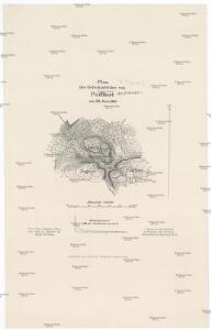
Plan des Gefechtsfeldes von Podkost am 28. Juni 1866
1 : 25000 Bothe
Podkost - c5896-1-005 - Kaiserpflichtexemplar der Landkarten des stabilen Katasters
1 : 2880
Podkost - c5896-1-004 - Kaiserpflichtexemplar der Landkarten des stabilen Katasters
1 : 2880
Podkost - c5896-1-002 - Kaiserpflichtexemplar der Landkarten des stabilen Katasters
1 : 2880
Podkost - c5896-1-003 - Kaiserpflichtexemplar der Landkarten des stabilen Katasters
1 : 2880
Podkost - c5896-1-001 - Kaiserpflichtexemplar der Landkarten des stabilen Katasters
1 : 2880
Zehrow - c9380-1-002 - Kaiserpflichtexemplar der Landkarten des stabilen Katasters
1 : 2880
Zehrow - c9380-1-006 - Kaiserpflichtexemplar der Landkarten des stabilen Katasters
1 : 2880
Zehrow - c9380-1-003 - Kaiserpflichtexemplar der Landkarten des stabilen Katasters
1 : 2880
Zehrow - c9380-1-005 - Kaiserpflichtexemplar der Landkarten des stabilen Katasters
1 : 2880
Zehrow - c9380-1-007 - Kaiserpflichtexemplar der Landkarten des stabilen Katasters
1 : 2880
Zehrow - c9380-1-004 - Kaiserpflichtexemplar der Landkarten des stabilen Katasters
1 : 2880
Zehrow - c9380-1-001 - Kaiserpflichtexemplar der Landkarten des stabilen Katasters
1 : 2880
Nepřiwetz (Nepřiwec) - c5049-1-002 - Kaiserpflichtexemplar der Landkarten des stabilen Katasters
1 : 2880
Nepřiwetz (Nepřiwec) - c5049-1-003 - Kaiserpflichtexemplar der Landkarten des stabilen Katasters
1 : 2880
Nepřiwetz (Nepřiwec) - c5049-1-004 - Kaiserpflichtexemplar der Landkarten des stabilen Katasters
1 : 2880
Nepřiwetz (Nepřiwec) - c5049-1-001 - Kaiserpflichtexemplar der Landkarten des stabilen Katasters
1 : 2880
Lhota Ritiřowa (Lhotarytjřowa) - c6672-1-001 - Kaiserpflichtexemplar der Landkarten des stabilen Katasters
1 : 2880
Lhota Ritiřowa (Lhotarytjřowa) - c6672-1-003 - Kaiserpflichtexemplar der Landkarten des stabilen Katasters
1 : 2880
Lhota Ritiřowa (Lhotarytjřowa) - c6672-1-002 - Kaiserpflichtexemplar der Landkarten des stabilen Katasters
1 : 2880
Plan zum Gefechte bei Podkost am 29. Juni 1866
1 : 28880 Podkost (Libošovice, Česko) Ditfurth, Moritz von des K. u. k. Militärgeographischen Instituts
Plan zum Gefechte bei Podkost am 29. Juni 1866
1 : 29000
Mapa politického okresu Turnovského

Gradkartenblatt
1 : 25000 Jičín-oblast (Česko) Bellschan, Anton

III. vojenské mapování 3854/2
1 : 25000
Karte der Denkmale der im Treffen bei Jičín am 29-ten Juni 1866 Gefallenen

III. vojenské mapování 3754/4
1 : 25000
Jičín a okolí
1 : 75000 Jičín (Česko : oblast) Vojenský zeměpisný ústav