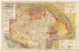
Maps of Carpathian Mountains

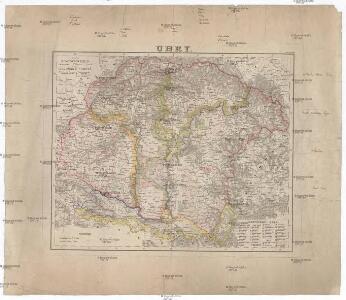
Uhry
1 : 1870000 Maďarsko
Uhry
1 : 1870000 Maďarsko
Uhry
1 : 1870000 Maďarsko
Ungarn und ein Theil von Siebenbürgen
Stieler's Hand-Atlas Stieler, Adolf bei Justus Perthes
Ungarn und ein Theil von Siebenbürgen
Hand-Atlas über alle Theile der Erde nach dem neuesten Zustande und über das Weltgebäude Stieler, Adolf bei Justus Perthes
Ungarn und ein Theil von Siebenbürgen
Hand-Atlas über alle Theile der Erde nach dem neuesten Zustande und über das Weltgebäude Stieler, Adolf bei Justus Perthes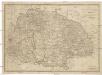
Ungarn sam[m]t der vereinigten Ländern und Siebenbürgen
Maďarsko Hocke, Jan Kapras, Jan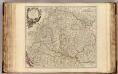
Hongrie, Transilvanie, Sclavonie, Croatie, Valaquie, Bosnie, Bulgarie.
1 : 1450000 Robert de Vaugondy, Gilles, 1688-1766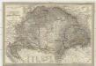
Magyar-ország
1 : 1400000 Chorvatsko Fried, Franz List, Joseph bei Artaria &. Comp.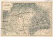
Uibersichts Karte des Kriegsschauplatzes von Ungarn und Siebenbürgen
1 : 1470000 Maďarsko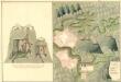
Plan der Bergstadt Terestian
Mollova mapová sbírka Geyer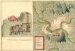
Plan des Gold und Silber Berg Adamos
Mollova mapová sbírka Geyer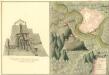
Plan der Bergstat Bogan
Mollova mapová sbírka Geyer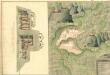
Plan der Bergstadt Abrugbania
Mollova mapová sbírka Geyer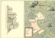
Plaan des Haupt Bergwerg Maidanpeg
Mollova mapová sbírka Geyer
Ungarn, Siebenburgen, Slavonien, Kroatien.
1 : 1850000 Stieler, Adolf
Regni Hungariae
1 : 1450000 Uhersko Müller, Johann Christoph Homann, Johann Baptist J. B. Homann
Regni Hungariae
1 : 1450000 Uhersko Müller, Johann Christoph Homann, Johann Baptist J. B. Homann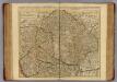
Hongrie, Transilvanie, Croatie, Sclavonie.
1 : 1390000 L'Isle, Guillaume de, 1675-1726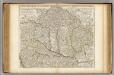
Hongrie, Transilvanie, Croatie, Sclavonie.
1 : 1390000 L'Isle, Guillaume de, 1675-1726
Karte des ungarischen Communikations-Netzes
1 : 1140000 Evropa jihovýchodní
Länder der Ungarischen Krone: Ungarn, Siebenbürgen, Slavonien und ein Theil von Kroatien
Handatlas über alle Theile der Erde und über das Weltgebäude Stieler, Adolf Justus Perthes
Karte der Königreiche Ungarn, Croatien, Slavonien und Militärgrenzen

Carte particuliere de la Hongrie de la Transilvanie de la Croatie et de la Sclavonie
1 : 1400000 Chorvatsko Delisle, Guillaume J. Covens et C. Mortier
Magyarország és a' Hozzá kapcsolt tartományok Földabrosza
1 : 970000 Chorvatsko Raffelsperger, Franz Raffelsperger F.
REGNI HUNGARIAE Tabula Generalis
1 : 1500000 Maďarsko Homann, Johann Baptist Müller, Johann Christoph á Io. Bapt. Homanno
REGNI HUNGARIAE Tabula Generalis
1 : 1500000 Maďarsko Homann, Johann Baptist Müller, Johann Christoph á Io. Bapt. Homanno
Regni Hungariae tabula generalis
1 : 1441000 Maďarsko Homann, Johann Baptist Müller, Johann Christoph á Io. Bapt. Homanno
Hvngaria seu Tvrcia in Octo Capitaneatus diuisa
1 : 4300000 Mollova mapová sbírka