Maps of Erzgebirgskreis

Chemnitz
1 : 120000 Chemnitz-oblast (Německo) Kön. Kameral-Vermessung u. Graviranstalt
129. Chemnitz, uit: Topographische Uebersichtskarte des Deutschen Reiches / herausgegeben v. d. Kartogr. Abt. d. Königl. Preuß. Landesaufnahme
1 : 200000 titelvariant: Topogr. Übersichtskarte des Deutschen Reiches; Annotatie: Titel boven bladen ook: Topogr. Übersichtskarte des Deutschen Reiches; Annotatie geografische gegevens: Op elk blad twee maatstokken: 10 Kilometer = 5,5 cm; 1 geogr. Meile = 3,6 cm; Legenda onder op elk blad Königlich Preußische Landesaufnahme. Kartographische Abtheilung [S.l : Königlich Preußische Landesaufnahme, Kartographische Abtheilung]
166 Zwickau, uit: Topographische Special-Karte von Deutschland (von Central-Europa) / begründet von D.G. Reymann ; [entworfen und gezeichn. von Heinrich Berghaus... [et al.]]
1 : 200000 Annotatie: Lit.: Daniel Gottlob Reymann und die "Topographische Special-Karte von Deutschland" / von Wolfgang Scharfe, in: Kartographische Nachrichten, 39 (1989), Heft I, p. 1-10; Handgeschreven titel: Reymann's Deutschland : 24 Sectionen: Jena, Penig, Dresden, Zittau, Hirschberg, Breslau, Brieg, Andernach, Coblenz, Giessen, Fulda, Schleusingen, Plauen, Zwickau, Teplitz, Jung Bunzlau, Hohenelbe, Glatz, Neisse, Simmern, Prag, Luxemburg, Birkenfeld; Aanwezig: 23 bladen Reymann, Daniel Gottlob; Berghaus, Heinrich [Berlin : 2. Departement des Kriegsministeriums, Bureau für Plan- und Kartenzeichnung]
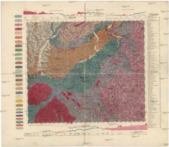
Kahle's Höhenschichtenkarte des Erzgebirges
1 : 100000 Krušné hory (Česko a Německo) Hofbuchdruckerei H. Kahle
Sebastianberg und Sachs. Annaberg.
from Spezialkarte der osterreichisch-ungarischen Monarchie.
Mappa geographica regni Bohemiae in duodecim circulos divisae ...

Sebastiansberg und Sächs. Annaberg
1 : 75000 Hora Svatého Šebestiána-oblast (Česko) K. u. k. Militärgeographisches Institut
Sebastiansberg und Sächs. Annaberg
1 : 75000 Čechy (Česko) Brunner, J. K. u. k. Militärgeographisches Institut
III. vojenské mapování 3750
1 : 75000
Nová Mapa království Českého
1 : 200000 Čechy severozápadní (Česko) Kotyška, Václav Hanf, Norbert Bursík & Kohout

Hora Sv. Šebestiána
1 : 75000 Hora Svatého Šebestiána (Česko) Vojenský zeměpisný ústav
Hora Sv. Šebestiána
1 : 75000 Hora Svatého Šebestiána-oblast (Česko) Vojenský zeměpisný ústav
Hora Sv. Šebestiána
1 : 75000 Hora Svatého Šebestiána (Česko) Vojenský zeměpisný ústav
Fichtelberggebiet

[Kartenblatt]
1 : 25000 Hora Svatého Šebestiána-oblast (Česko) Reichsamt für Landesaufnahme
[Kartenblatt]
1 : 25000 Annaberg-Buchholz (Německo) Reichsamt für Landesaufnahme
III. vojenské mapování 3750/4
1 : 25000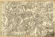
Grund-Riess Der gantzen Schemnitzer Revier
Mollova mapová sbírka Ziepser, Matthäus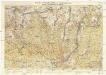
Wander- und Wintersportkarte des Erzgebirges
1 : 30000 Fichtelberg (Krušné hory, Německo : hora) G.A. Kaufmanns Buchhandlung
III. vojenské mapování 3750/4
1 : 25000
III. vojenské mapování 3750/4
1 : 25000
III. vojenské mapování 3750/4
1 : 25000
Meßtischblatt 5445 : Sebastiansberg, 1939
1 : 250000 Sebastiansberg. - Aufn. 1914, 1919 u. 1920, hrsg. 1924, bericht. 1936 u. 1938. - 1:25000. - Leipzig, 1939. - 1 Kt.
Meßtischblatt 5445 : Reitzenhain, 1938
1 : 250000 Reitzenhain. - Umdr.-Ausg., aufgen. 1914, 1919 u. 1920, hrsg. 1924, einz. Nachtr. 1932. - 1:25000. - Leipzig, 1938. - 1 Kt.
Meßtischblatt 139 : Annaberg, 1935
1 : 250000 Annaberg. - Umdr.-Ausg., aufgen. 1914, 1919 u. 1920, hrsg. 1924, bericht. 1932. - 1:25000. - Leipzig, 1935. - 1 Kt.
Meßtischblatt 5443 : Buchholz, 1944
1 : 250000 Buchholz. - Aufn. 1914, 1919 u. 1920, hrsg. 1924, bericht. 1936, Ausg. 1943. - 1:25000. - Leipzig, 1944. - 1 Kt.
Meßtischblatt 5443 : Buchholz, 1942
1 : 250000 Buchholz. - Aufn. 1914, 1919 u. 1920, hrsg. 1924, bericht. 1936. - 1:25000. - Leipzig, 1942. - 1 Kt.
Meßtischblatt 5442 : Schwarzenberg, 1941
1 : 250000 Schwarzenberg. - Aufn. 1913, hrsg. 1917, bericht. 1937. - 1:25000. - Leipzig, 1941. - 1 Kt.
Meßtischblatt 137 : Schwarzenberg, 1935
1 : 250000 Schwarzenberg. - Umdr.-Ausg., aufgen. 1913, hrsg. 1917, bericht. 1925, einz. Nachtr. 1935. - 1:25000. - Leipzig, 1935. - 1 Kt.