Maps of Croatia

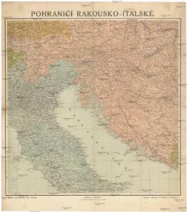
Pohraničí rakousko-italské
1 : 1250000 Itálie severní Machát, František V. Neubert
Pohraničí Rakousko-Italské
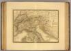
Italie, Suisse, Illyrie nord.
1 : 2100000 Picquet, C.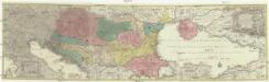
Tabula synoptica totius fluminis Danubii a fontibus usque ad ostia
1 : 2000000 Besarábie (Moldavsko a Ukrajina) Lotter, Tobias Conrad Tobias Conrad Lotter
Carta postale e stradale dell'Italia
1 : 1050000 Itálie Pinneti, G. A. F. Artaria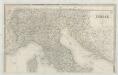
Italia
1 : 1140000 Sacchi, Ferd. Ditta Artaria di Ferd.o Sacchi e figli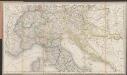
[Post und Reisekarte von Italien und den nördlich angrenzenden Alpenländern]
1 : 1800000 Roost, Johann Baptist J.G. Cotta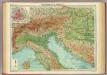
Northern Italy, Austria, &c.
1 : 2000000 John Bartholomew and Son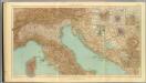
24-26. Italia nord.
1 : 1500000 Touring club italiano
Carte Generale de L'Italie.
1 : 2800000 Vivien de St Martin, L.
Partie, l'Italie. Europe 20.
1 : 1641836 Vandermaelen, Philippe, 1795-1869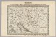
Key Sheet: Karte Des Oesterreichischen Kaiserstaates.
1 : 576000 Scheda, Josef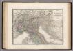
Italie partie Nord.
1 : 2090000 Levasseur, E.
Carta postale ed itineraria dell'Italia
Itálie Botte, A. F. Deyé A.F. Botte
Carta postale ed itineraria dell' Italia
Chorvatsko Botte, A.F.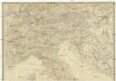
Italien
Itálie severní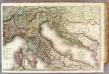
France 4.
1 : 1170000 Brue, Adrien Hubert, 1786-1832; Herisson, Eustache, b. 1759
Ethnographical map (Eastern Europe). Northern Italy 1918
1 : 1500000 First World War ethnographical map (Eastern Europe). 1918. Four sheets, covering Germany, Poland, Northern Italy and South eastern Europe. To illustrate the post-WW1 settlement. War Office
Pannoniae, Et Illyrici Veteris Tabula. [Karte], in: Theatrum orbis terrarum, S. 383.
1 Karte aus Atlas Ortelius, Abraham
Italien nordliche Halfte.
1 : 2600000 Andree, Richard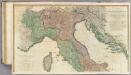
Italy N.
1 : 1010000 Faden, William, 1750?-1836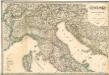
Italia settentrionale e centrale

Pannoniae, Et Illyrici Veteris Tabula. [Karte], in: Theatrum orbis terrarum, S. 484.
1 Karte aus Atlas Ortelius, Abraham Vrients, Jan Baptista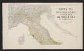
Mortalità per infezione malarica in ciascun comune del Regno d'Italia nei tre anni 1890-91-92
1 : 1000000 Nordblatt R. Stab. Carto-Lit. C. Virano e C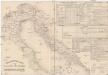
Etablissements der kaiserlichen königlichen Kriegsmarine
Jaderské moře-oblast
[Österreich-Ungarn, Blatt 3]
Adolf Stieler's Handatlas über alle Theile der Erde und über das Weltgebäude Stieler, Adolf Justus Perthes
Carta delle provincie Illiriche co'loro diversi stabilimenti e con una parte degli stati limitrofi
1 : 500000 Ilýrie Bordiga, Benedetto
Tabula Itineraria Vienna Austriae Metropoli ad Orbis Urbem Romam
Mollova mapová sbírka Lidl, Johann Jakob Lidl, Johann Jacob
Carta postale e stradale dell'Italia
1 : 1000000 Pinneti, G.A.F. Artaria & Comp.