Maps of Czech Republic
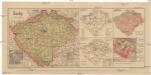
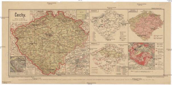
Čechy
1 : 1300000 Praha-oblast (Česko) Salač, Klement B. Kočí
General-Karte des Königreiches Böhmen
1 : 378000 Čechy (Česko) Kořistka, Karel František Edvard Sommer, Adolf Eduard Hölzel's Verlag
Post-Charte vom Königreiche Böheim
1 : 925000 Česko Kreibich, František Jakub Jindřich Rainold, Karl Eduard C.E. Rainold
Post-Charte vom Königreiche Böheim
1 : 925000 Česko Kreibich, František Jakub Jindřich Rainold, Karl Eduard C.E. Rainold
Post-Charte vom Königreiche Böheim
1 : 925000 Česko Kreibich, František Jakub Jindřich Rainold, Karl Eduard C.E. Rainold
Post-Charte vom Königreiche Böheim
1 : 925000 Česko Kreibich, František Jakub Jindřich Rainold, Karl Eduard C.E. Rainold
Post-Charte vom Königreiche Böheim
1 : 925000 Česko Kreibich, František Jakub Jindřich Rainold, Karl Eduard C.E. Rainold
Mapa Králowstwj českého
1 : 740000 Čechy (Česko) David, Martin Alois Berka, Jan Nepomuk nákladem p. p. Benesse Jana Nepom. Pfeifera
Mapa Králowstwj českého
1 : 740000 Česko David, Martin Alois Berka Jan Nepomuk nákladem p. p. Benesse Jana Nepom. Pfeifera
Karte vom Königreiche Böhmen in Cameralämtlicher Hinsicht
Praha (Česko) Seidler, Karl Friedrich
Čechy
Česko Gräf, C. Langhans, J.
Königreich Böhmen
Česko Tachauer, Ludwig Langhans, J.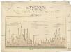
Höhen-Karte, oder, Vergleichende Tafel der barometrischgemessenen Berg- und Städte-Höhen Boehmens
Česko Dlask, Vavřinec Vojtěch Langweil, Antonín Schönfeldische Steindruckerey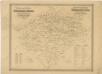
Archeologická mapa království Českého

Topographisch-statistische Post und Strassenkarte des Königreiches Boehmen nach der neuen politischen Eintheilung
1 : 400000 Praha (Česko) Anděl, Bedřich bei Marco Berra
Království české
1 : 570000 Česko Wagner, Jan Eduard Jan Ed. Wagner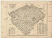
Království české
1 : 570000 Česko Wagner, Jan Eduard Jan Ed. Wagner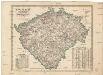
Království české
1 : 570000 Česko Wagner, Jan Eduard Jan Ed. Wagner
Království české
1 : 570000 Česko Wagner, Jan Eduard Jan Ed. Wagner
Karte des Königreich's Boehmen
1 : 415000 Česko Friedrich Kretzschmar
Čechy
1 : 500000 Čechy (Česko) Havránek, J. E. Fastr
Nejnovější příruční mapa Království Českého

Národnostní mapa Království Českého na základě sčítání lidu z roku 1880

Das Königreich Böhmen
Čechy (Česko) Benecke Bormann, E. Ignaz Fuchs
[Soudní okresy Čech]
1 : 500000 Česko
[Soudní okresy Čech]
1 : 1000000 Česko
[Soudní okresy Čech]
1 : 750000 Česko
Cesty ptáků zemních v Čechách
Čechy (Česko) Šír, Vladislav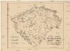
Cesty ptáků bahních a vodních v Čechách
Čechy (Česko) Schier, Vladislav