Maps of Špindlerův Mlýn
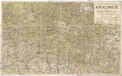
Turistická mapa Krkonoš
1 : 56000 Krkonoše (Česko a Polsko) Dvořák, Karel Klub československých turistů
Turistická mapa Krkonoš
1 : 56000 Krkonoše-oblast (Česko a Polsko) Buchar, Jan Šolc a Šimáček
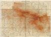
Petrographische Charte eines Theils des böhmischen Riesengebirges an der schlesischen Gränze
1 : 82600 Krkonoše (Česko a Polsko) Jirasek, Johann
Petrographische Charte eines Theils des böhmischen Riesengebirges an der schlesischen Gränze
1 : 82600 Krkonoše (Česko a Polsko) Jirasek, Johann
Podrobná mapa Království českého
1 : 100000 Jilemnice (Česko : oblast) Srp, Jan Jaroslav Bursík
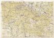
Krkonoše
1 : 100000 Krkonoše (Česko a Polsko : pohoří) Srp, Jan Jos. R. Vilímek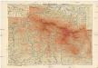
Riesengebirge
1 : 50000 Krkonoše-oblast (Česko a Polsko) Semík, Matěj V. Neubert & Söhne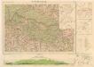
Krkonoše
Meinhold's Wanderkarte vom Riesengebirge
1 : 50000 Krkonoše (Česko a Polsko) Winkler, P. C.C. Meinhold & Söhne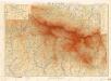
Krkonoše
Krkonoše
Turistická mapa Krkonoš
1 : 60000 Krkonoše-oblast (Česko a Polsko) Josef Uher
Podrobné mapy zemí Koruny české v měřítku 1:75.000 a mapa vzdáleností všech míst při silnici ležících - Krkonoše - Vrchlabí - Žacléř. Průvodce statisticko-historický po všech místech na těchto mapách uvedených a rejstřík věcný názvů hor, potoků, řek, rybníků atd. Sešit 9. List 88,
1 : 75000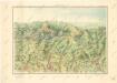
Krkonoše

Riesen-Gebirge
1 : 75000 Krkonoše-oblast (Česko a Polsko) Brey, Otto Alexander Köhler
Charte vom Riesengebirge
1 : 160000 Krkonoše (Česko a Polsko) Mattis, Carl Klinkert, F. C. Mattis
Relief-Wanderkarte vom Riesengebirge
1 : 50000 Krkonoše (Česko a Polsko) Bienert, Richard Richard Bienert
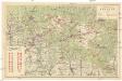
Wintersportkarte vom Riesengebirge
1 : 75000 Krkonoše-oblast (Česko a Polsko) Mittelbach, R. Mittelbach's Verlag
Riesengebirge
1 : 50000 Krkonoše-oblast (Česko a Polsko) Winkler, P. C.C. Meinhold & Söhne
Riesengebirge
1 : 50000 Krkonoše-oblast (Česko a Polsko) Winkler, P. C.C. Meinhold
Mittelbach ́s neueste Spezialkarte des Riesengebirskammes mit näheren Umgebung

Übersichts- und Terrainkarte der gräflich Czernin-Morzin'schen Domainen Hohenelbe und Marschendorf im Riesengebirge
1 : 50000 Horní Maršov (Česko) R. Mittelbach
Mapka Krkonošů
1 : 160000 Krkonoše-oblast (Česko a Polsko)
Lyžařská mapa Krkonoš
1 : 116000 Krkonoše-oblast (Česko a Polsko) Macháček, Vil. Svaz lyžařů RČS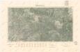
Krkonoše

Petrographische Charte eines Theils des Böhmischen Riesengebirges an der Schlesischen Gränze

[Kartenblatt]
1 : 25000 Krkonoše (Česko a Polsko : pohoří) Reichsamt für Landesaufnahme
[Kartenblatt]
1 : 25000 Krkonoše (Česko a Polsko : pohoří) Reichsamt für Landesaufnahme