Maps of Czech Republic

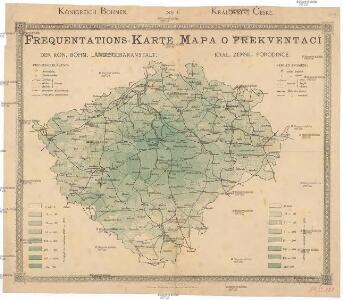
Frekventations-Karte der kön. böhm. Landesgebäranstalt
Čechy (Česko)
Mapa Království českého
Čechy (Česko) Křesina, Ant. Pukl, D.
Karte von dem Koenigreich Boeheim
1 : 530000 Čechy (Česko) Walch, Johann Joh. Walch
Karte von dem Koenigreich Boeheim
1 : 530000 Čechy (Česko) Walch, Johann Joh. Walch
Stellung der Blaetter
Česko
Karte von Böhmen
Čechy (Česko) Habel, Johann K.
Geologická mapa Království českého
1 : 1000000 Čechy (Česko) Wagner, Jan Eduard Fr. A. Urbánek
Uibersichtskarte der neuen Eintheilung des Koenigreiches Boehmen

Das Königreich Böhmen
1 : 670000 Karlovy Vary (Česko) Weiland, Karl Ferdinand im Verlage des Geograph. Institut
Das Königreich Böhmen
Čechy (Česko) Weiland, Karl Ferdinand Schrober, Karel im Verlage des Geograph. Institut
Mapka lázní, léčebných míst a letních sídel v království Českém [sic]
Česko
Post= Charte vom Königreiche Böheim
mapa VKOL Kreibich, František Jakub Jindřich Herausgegeben von C.E. Rainold
Isochronická mapa Čech s úvodem o isochronii vůbec
[Mapa hustoty železniční sítě v Čechách]
1 : 1000000 Čechy (Česko) Novák, Fr.
Karten zur Statistik des Königreiches Böhmen

Karte von Böhmen
1 : 518400 Česko
Bohemia in suas partes geographicé distincta

Králowstwí České

Školní závěsná mapa Království českého
1 : 288000 Česko Křížek, Václav v komisi Karla Janského
Království české
Česko Schlieben Ausfeld, Johann Carl sklad a tisk F. Líbiše
Topographisch-statistische Post und Strassenkarte des Königreiches Boehmen nach der neuen politischen Eintheilung
1 : 400000 Praha (Česko) Anděl, Bedřich bei Marco Berra
Příruční mapa Království českého
1 : 600000 Česko Wagner, Jan Eduard F. Kytka
Králowstwj české
Česko Wondra, Jos. Havlík, H.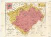
Uibersichtskarte des Königreiches Böhmen
1 : 576000 Jablonec nad Nisou (Česko : oblast) Wagner, Jan Eduard F. Kytka
Mappa geographica totius Regni Bohemiae in 12. circulos divisae, annexis comitatu Glacensi et districtu Egerano nec non aliis principatib. finitimis
1 : 730000 Kladsko-oblast (Polsko) Lotter, Tobias Conrad T. C. Lotter
Generální mapa Království českého
1 : 220000 Čechy (Česko) Wagner, Jan Eduard Mareš, František F. Kytka
Isochronická mapa Čech
1 : 750000 Čechy (Česko) Nový, Václav
Isochronenkarte Boehmens
1 : 750000 Čechy (Česko) Nový, Václav
Přehledná mapa pokračovacích škol průmyslových, kupeckých a j. v Království českém
Česko c. a k. dvorní litografie A. Haase