Maps of Israel

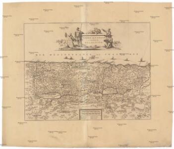
Terre de Canaan á present la Palestine
1 : 1100000 Kanaán
Palestine sous la domination romaine.
1 : 800000 Picquet, C.
Palestine sous la Domination Romaine.
Levasseur, E.
Palestina

Turkey in Asia (Biblical Regions) The Holy Land And Its Borders.
1 : 696960 Fullarton, A. & Co.
Palestine
1 : 1000000 Colton, G.W.
Judaea seu Terra Sancta quae Hebraeorum sive Israelitarum in suas duodecim tribus divisa, secretis ab invicem regnis Juda, et Israel expressis insuper sex ultimi temporis ejusdem terrae provincijs
1 : 740000 ex conatibus geographicis Gulielmi Sanson [...] A Amsterdam : chez Pierre Schenk
Palästina
Plastischer Schul-Atlas über alle Theile der Erde : in 24 Karten Woldermann, G Verlag von P. Eckerlein
Palestine (with) Arabia Petraea.
1 : 1013760 Colton, G.W.
Palästina oder Kanaan zur Zeit des Israelitischen Reiches
Palestina Kiepert, Heinrich Arnd Geographisches Institut
La Judee, Canaan.
1 : 850000 Robert de Vaugondy, Gilles, 1688-1766


Carta della Palestina sotto il dominio de'Romani
1 : 680000 Marzolla, Benedetto [Verlag nicht ermittelbar]
Palestina za doby soudců a králů

Judaea sive Terra Sancta quae Israelitarum suas duodecim tribus distincta, secretis ab invicem regnis Juda, et Israel expressis in super sex ejusdem terrae provincijs
1 : 650000 ex conatibus geographicis Gulielmi Sanson [...] Amst[erdam] : ex officina R. & J. Ottens
Palestina nynější
Palestine (ancient).
1 : 1320000 Migeon, J.
[Kaart], uit: Neue Handkarte von Palästina / bearb. von Hans Fischer und H. Guthe
1 : 700000 Fischer, Hans (fl. 1910); Guthe, Hermann Leipzig : Wagner & Debes
Homannův atlas světa
1 : 570000
Palestine sous la domination romaine.
1 : 800000 Brue, Adrien Hubert, 1786-1832
Kaart van 't land Kanaan / naar de beste waarnemingen tot verstand van Num. XXI:14-31 ontworpen door R. Schutte ; J. van Jagen sculps. 1766
1 : 800000 Annotatie: Waarschijnlijk blad uit zakatlas Schutte, Rutger; Jagen, J. van Te Amsterdam : by J. Loveringh
Palaestina: ex veteris aevi monumentis ac recentiorum observationibus
1 : 450000 illustravit Marinus Didericus de Bruyn sculpsit Georgius Mayr Amstelodami : De Grebber
Palestine.
1 : 1120000 Finley, Anthony
Palaestina.
Palestina Kiepert, Heinrich Arnd
Palaestina
1 : 640000 Palestina Reichard, Christian Gottlieb Campius, D. a D. Campio
Bez titulu: Historický Atlas

Palestine.
1 : 1000000 Andree, Richard; Times (London, England)
Palestine.
1 : 1027000 Johnson, A.J.