Maps of Most

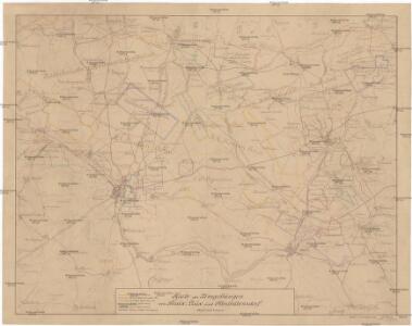
Karte der Umgebungen von Brüx, Dux und Oberleutensdorf
1 : 25000 Duchcov-oblast (Česko) Schulz, Josef
Atlas d'industrie de la république tchécoslovaque

III. vojenské mapování 3751/4
1 : 25000
[Kartenblatt]
1 : 25000 Bílina (Česko : oblast) Reichsamt für Landesaufnahme
[Kartenblatt]
1 : 25000 Bílina (Česko : oblast) Reichsamt für Landesaufnahme

Geologická mapa okolí Bíliny
1 : 25000 Bořeň (České středohoří, Česko : hora) Hibsch, Josef Emanuel Státní geologický ústav Československé republiky
Geologická mapa okolí Mostu
1 : 25000 Most (Česko : oblast) Hibsch, Josef Emanuel Purkyně, Cyrill Státní geologický ústav Československé republiky
Geologische und Gruben-Revier-Karte des Kohlenbeckens von Teplitz-Dux-Brüx
1 : 10000 Blatt 7 Wolf, Heinrich Lithografie u. Schnell-Pressen-Druck des k.k. Militär-geografischen Institutes
Geologische und Gruben-Revier-Karte des Kohlenbeckens von Teplitz-Dux-Brüx
1 : 10000 Blatt 12 Wolf, Heinrich Lithografie u. Schnell-Pressen-Druck des k.k. Militär-geografischen Institutes
Geologische und Gruben-Revier-Karte des Kohlenbeckens von Teplitz-Dux-Brüx
1 : 10000 Blatt 11 Wolf, Heinrich Lithografie u. Schnell-Pressen-Druck des k.k. Militär-geografischen Institutes
Brüx - c4845-1-013 - Kaiserpflichtexemplar der Landkarten des stabilen Katasters
1 : 2880
Brüx - c4845-1-006 - Kaiserpflichtexemplar der Landkarten des stabilen Katasters
1 : 2880
Brüx - c4845-1-010 - Kaiserpflichtexemplar der Landkarten des stabilen Katasters
1 : 2880
Brüx - c4845-1-012 - Kaiserpflichtexemplar der Landkarten des stabilen Katasters
1 : 2880
Brüx - c4845-1-009 - Kaiserpflichtexemplar der Landkarten des stabilen Katasters
1 : 2880
Brüx - c4845-1-003 - Kaiserpflichtexemplar der Landkarten des stabilen Katasters
1 : 2880
Brüx - c4845-1-001 - Kaiserpflichtexemplar der Landkarten des stabilen Katasters
1 : 2880
Brüx - c4845-1-002 - Kaiserpflichtexemplar der Landkarten des stabilen Katasters
1 : 2880
Brüx - c4845-1-011 - Kaiserpflichtexemplar der Landkarten des stabilen Katasters
1 : 2880
Brüx - c4845-1-007 - Kaiserpflichtexemplar der Landkarten des stabilen Katasters
1 : 2880
Brüx - c4845-1-004 - Kaiserpflichtexemplar der Landkarten des stabilen Katasters
1 : 2880
Brüx - c4845-1-005 - Kaiserpflichtexemplar der Landkarten des stabilen Katasters
1 : 2880
Brüx - c4845-1-008 - Kaiserpflichtexemplar der Landkarten des stabilen Katasters
1 : 2880
Geologische und Gruben-Revier-Karte des Kohlenbeckens von Teplitz-Dux-Brüx
1 : 10000 Blatt 8 Wolf, Heinrich Lithografie u. Schnell-Pressen-Druck des k.k. Militär-geografischen Institutes
Stadtplan von Brüx
1 : 8000 Most (Česko) Deutsche Landvolksbuchhandlung
Geologische und Gruben-Revier-Karte des Kohlenbeckens von Teplitz-Dux-Brüx
1 : 10000 Blatt 6 Wolf, Heinrich Lithografie u. Schnell-Pressen-Druck des k.k. Militär-geografischen Institutes
Bruch - c4223-1-001 - Kaiserpflichtexemplar der Landkarten des stabilen Katasters
1 : 2880
Bruch - c4223-1-004 - Kaiserpflichtexemplar der Landkarten des stabilen Katasters
1 : 2880
Bruch - c4223-1-007 - Kaiserpflichtexemplar der Landkarten des stabilen Katasters
1 : 2880
Bruch - c4223-1-003 - Kaiserpflichtexemplar der Landkarten des stabilen Katasters
1 : 2880
Bruch - c4223-1-005 - Kaiserpflichtexemplar der Landkarten des stabilen Katasters
1 : 2880
Bruch - c4223-1-006 - Kaiserpflichtexemplar der Landkarten des stabilen Katasters
1 : 2880