Maps of Baden-Württemberg
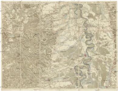
Kriegs Theater der teutschen und franzoesischen Graenzlanden zwischen dem Rhein und der Mosel im Jahr 1796
1 : 100000 Mosel (Německo) Dewarat, Peter
Kriegs Theater der teutschen und franzoesischen Graenzlanden zwischen dem Rhein und der Mosel im Jahr 1794
1 : 90000 Mosel (Německo) Dewarat, Peter Leizel, Balthasar Friedrich I.L.C. Rheinwald
Theatrum Belli ad Rhenum Superior. nec non Munimentorum tum Imperialium, tum Gallicorum ichnographica exhibitio accurate tradita
1 : 375000 Mollova mapová sbírka Homann, Johann Baptist Homann, Johann Baptista - dědici
Alsatia Landgraviatus cum utroque Marchionatu Badensi, Sundgovia Brisgovia, magno tractu Hereiniae Silvae et ditione IV. Urbium Silvestrium Cura et Sumtibus Matth. Seutteri, Chalc. August.
1 : 375000 Mollova mapová sbírka Seutter, Matthäus Seutter, Matthäus

Le theatre de la guerre sur le Haut Rhein et dans la Souabe sur le Danube &c
1 : 405500 Dunaj-oblast Bourgoin
L'Alsace
1 Karte : Kupferdruck ; 45 x 57 cm Sanson s.n.
Straßen im Großherzogtum Baden 1848
Baden Straßennetz Kunz, Andreas ; Treiling, Thomas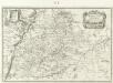
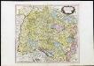
Wirtenberg Dvcatus
1 : 1000000 Mollova mapová sbírka Merian, Matthaeus Merian, Matthäus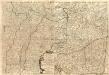
Le Theatre de la Guerre Sur le Haut Rhein Contenant l'Alsace
1 : 480000 Mollova mapová sbírka Nolin, Jean-Baptiste Rousseau, L. B. Leonard, Jean
Gross Herzogthum Baden
Grosser Hand-Atlas über alle Theile der Erde in 170 Karten Meyer, J. Verlag des Bibliographischen Instituts
Baden.
1 : 870000 Andree, Richard; Times (London, England)
Baden.
1 : 870000 Andree, Richard
[Charte vom Königreich Würtemberg, und dem Grossherzogthum Baden]
Neuester Schul-Atlas Walch, Johann im Verlag bei Joh. Walch
Karte von dem Grossherzogthum Baden
1 : 400000 Bádensko (Německo) Karten Büreau des Gr. Generalquartiermeisterstabs
Charte von dem Königreiche Wirtemberg, dem Grossherzogthume Baden und den königl. bayerschen Acquisitionen in Schwaben [et]c., oder der Ober=Rhein
1 Karte : Kupferdruck ; 44 x 49 cm im Verlage des Geograph. Instituts
Charte über das Grossherzogtum Baden / entworfen und revidirt von J.G. Tulla ; die Reduction und Zeichnung von Nachbarstaaten von Krauth ; F.X. Hutter sc.
1 : 500000 Tulla, J. G.; Krauth, ...; Hutter, F. X. Carlsruhe : C.F. Müller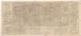
Charte geographique de la campagne de haut Rhin pour l'année 1734 contenant tous les mouvements marches et contremarches des armées imperiales et Francoises
Breisach am Rhein (Německo) Oettinger, Johann Friedrich Matthieu Seutter
Wurtemberg, Baden.
1 : 450000 Weiland, C. F. (Carl Ferdinand), d. 1847
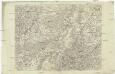
Charte des Schwaebischen Kreises
1 : 490000 Lichtenštejnsko im Verlage des Geograph. Instituts
Wirtenberg dvcatvs
1 Karte : Kupferdruck ; 40 x 48 cm Blaeu; Blaeu Willem und Joan Blaeu
Charte über das Grossherzogthum Baden
1 : 510000 Bádensko (Německo) Hutter, F.H. C.F. Müller
Charte über das Grossherzogthum Baden
1 : 510000 Bádensko (Německo) Hutter, F. H. C.F. Müller
Charte über das Grossherzogthum Baden
1 : 504000 Bádensko (Německo) Hutter, F.H. C.F. Müller
Charte über das Grossherzogthum Baden
1 : 504000 Bádensko (Německo) Hutter, F. X. C.F. Müller
Charte über das Grossherzogthum Baden
1 : 504000 Bádensko (Německo) Hutter, F. H. C. F. Müller
Charte über das Grossherzogthum Baden
1 : 510000 Bádensko (Německo) Hutter, F. H. C.F. Müller
Der schwæbische Kreis. nebst den österreichischen Besizungen in Schwaben
1 Karte : Kupferdruck ; 46 x 51 cm im Verlage des Industrie-Comptoirs
Les Cours de Postes par le Cercle de Suabe, come ils se presentent dans la Carte Geographique
1 : 130000 Mollova mapová sbírka Homann, Johann Baptist Homann, Johann Baptista - dědici