Maps of Jihočeský

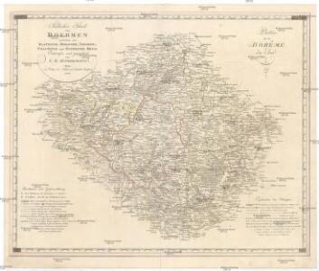
Südlicher Theil von Boehmen enthaltend den Klatttauer, Berauner, Taborer, Prachiner und Budweiser Kreis
Čechy jižní (Česko) Kindermann, Joseph Karl Kunst= und Industrie Comptoir
Südlicher Theil von Boehmen enthaltend den Klattauer, Berauner, Taborer, Prachiner und Budweiser Kreis
Čechy jižní (Česko) Kindermann, Joseph Karl im Verlage des Kunst- und Industrie Comptoirs
Generalkarte von Zentraleuropa
Militair Karte von Süd-Deutschland in 20 Sectionen
1 : 400000 8. Section Coulon, Alois von A. von Coulon
Karte des Taborer und Budweiser Kreises im österreichischen Kronlande Böhmen
1 : 285000 Tábor-oblast (Česko) Obentraut, Maxmilian Friedrich Kretzschmar
Carte topographique d'Allemagne contenant une partie du Royaume de Boheme
1 : 220000 Jihočeský kraj (Česko) Facius, Johann Gottlieb I. W. A. Iaeger
Carte topographique d'Allemagne contenant une partie du royaume de Boheme, savoir les cercles de Beraun, Kaurzin
1 Karte : Kupferdruck ; 46 x 62 cm Jaeger; Facius se vend chez I. W. A. Iaeger
Regni Bohemiae Circulus Prachinensis
1 : 200000 Prácheňsko (Česko) Müller, Johann Christoph Homannianorum Heredum
Regni Bohemiae Circulus Prachinensis
1 : 200000 Prácheňsko (Česko) Müller, Johann Christoph Homannianorum Heredum
Jihočeský kraj

Jihočeský kraj

Regni Bohemiae Circuli Taborensis et Budweisensis...

Tabor 117, uit: Special-Karte von Mittel-Europa / nach amtlichen Quellen bearbeitet von W. Liebenow
1 : 300000 titelvariant: W. Liebenow's Mittel-Europa; Annotatie: Titel boven de bladen: W. Liebenow's Mittel-Europa Johannes Wilhelm Liebenow 1822-1897 Frankfurt a. M. : Ludwig Ravenstein
Spezial-Karte des Taborer Kreis...

Deutsche Strassenprofilkarte für Radfahre.
Plzeň-oblast (Česko) Scheiner, Josef Mittelbach, R. J.C. Hinrichs
Kraj Českobudějovický
Nová Mapa království Českého
1 : 200000 Čechy jižní (Česko) Kotyška, Václav Hanf, Norbert Bursík & Kohout
[Nová Mapa království Českého]
1 : 200000 Čechy jižní (Česko) Kotyška, Václav Hanf, Norbert Bursík & Kohout
Regni Bohemiae Circulus Bechinensis
1 : 264000 Bechyně-oblast (Česko) Müller, Johann Christoph ab Homannianis Heredibus
Regni Bohemiae Circulus Bechinensis
1 : 264000 Bechyně-oblast (Česko) Müller, Johann Christoph ab Homannianis Heredibus
Charte vom Taborer Kreise des Königreichs Böheim
1 : 240000 Tábor-oblast (Česko) Kreibich, František Jakub Jindřich Pluth, Fr. C. W. Enders
Charte vom Taborer Kreise des Königreichs Böheim
1 : 240000 Tábor-oblast (Česko) Kreibich, František Jakub Jindřich Pluth, Fr. C. W. Enders
Táborský kraj v království Českém
Allgemeiner Übersichtsplan der böhmischen Kohlenbahn
1 : 347000 Čechy (Česko)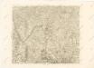
Mappa geographica regni Bohemiae in duodecim circuloc divisae ... Sectio. XVIII.

Taborer Kreis

Provincia Bechinensis
Bechyně-oblast (Česko) Bernardi, Augustin Augustin Bernardi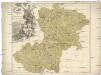
Provincia Bechinensis
Bechyně-oblast (Česko) Müller, Johann Christoph
Druhý zařizovací elaborát orlických lesů od Ing. Frant. Jos. Matze, Zámecký revír,kopie, list 2 1