Maps of Brandenburg
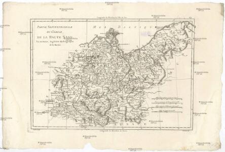
Partie septentrionale du cercle de la Haute Saxe
1 : 1740000 Sasko (Německo) Bonne, Rigobert André
Brandeburgum Marchionatus, cum Ducatibus Pomeraniae et Mekelenburgi. [Karte], in: Novus Atlas, das ist, Weltbeschreibung, Bd. 1, S. 99.
1 Karte aus Atlas Blaeu, Joan Blaeu, Willem Janszoon
Brandeburgum Marchionatus, cum Ducatibus Pomeraniae et Mekelenburgi. [Karte], in: Le théâtre du monde, ou, Nouvel atlas contenant les chartes et descriptions de tous les païs de la terre, Bd. 1, S. 128.
1 Karte aus Atlas Blaeu, Willem Janszoon und Blaeu, Joan Blaeu, Willem Janszoon
Marchionatus Brandenburgicus [Karte], in: Novus atlas absolutissimus, Bd. 2, S. 51.
1 Karte aus Atlas Janssonius Offizin
Brandeburgum Marchionatus, cum Ducatibus Pomeraniae et Mekelenburgi. [Karte], in: Theatrum orbis terrarum, sive, Atlas novus, Bd. 1, S. 161.
1 Karte aus Atlas Blaeu, Joan Blaeu, Willem Janszoon
Le Cercle de la Basse Saxe
1 : 770000 Mollova mapová sbírka Sanson, Guillaume Jaillot, Alexis Hubert
Le Cercle de la Basse Saxe
1 : 770000 Mollova mapová sbírka Sanson, Guillaume Jaillot, Alexis Hubert
Electoratus Brandenburgi, Mekelenburgi, Et maximae Partis Pomeraniae novissima Tabula. [Karte], in: Novus atlas absolutissimus, Bd. 2, S. 54.
1 Karte aus Atlas Janssonius Offizin
Marca Brandenburgensis & Pomerania. [Karte], in: Gerardi Mercatoris Atlas, sive, Cosmographicae meditationes de fabrica mundi et fabricati figura, S. 394.
1 Karte aus Atlas Mercator, Gerhard Montanus, Petrus
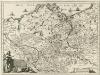
Marchionatus | BRANDENBVRGICVS
Auth. Olao Iohannis Gotho, Gustaui Mag. R.S. Cosm. [Amsterdam : Joan Blaeu]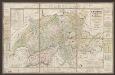
Tabula Electoratus Brandenburgici, Meckelenburgi, Et Maximae Partis Pomeraniae [...] [Karte], in: Gerardi Mercatoris et I. Hondii Newer Atlas, oder, Grosses Weltbuch, Bd. 1, S. 319.
1 Karte aus Atlas Mercator, Gerhard und Hondius, Jodocus Jansson, Jan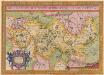
Brandeburgensis Marchae Descriptio. [Karte], in: Theatrum orbis terrarum, S. 141.
1 Karte aus Atlas Ortelius, Abraham
Bezirke der DDR 1952
Deutschland, DDR Kunz, Andreas ; Moeschl, Joachim Robert
Länder der DDR 3.10.1990
Deutschland, DDR Kunz, Andreas ; Moeschl, Joachim Robert
85. German Democratic Republic (East Germany). The World Atlas.
1 : 1250000 USSR (Union of Soviet Socialist Republics).
Circulus Saxoniae Inferioris
1 : 820000 Mollova mapová sbírka Valk, Gerhard
Länder der DDR 1949
Deutschland, DDR Kunz, Andreas ; Moeschl, Joachim Robert
German Democratic Republic. Pergamon World Atlas.
Polish Army Topography Service

Brandenburgum Marchionatus, cum Ducatibus Pomeraniae et Mekelenburgi
1 : 1100000 Mollova mapová sbírka Sandrart, Jakob von Sandrart, Jacob von
Brandenbvrgvm Marchionatvs
1 : 820000 Mollova mapová sbírka Janssonius, Johannes Janssonius, Johannes I
Tabula Marchionatus Brandenburgici et Ducatus Pomeraniae quae sunt Pars Septentrionalis Circuli Saxoniae Superioris novissime edita
1 : 1000000 Mollova mapová sbírka Homann, Johann Baptist Homann, Johann Baptista
Le Cercle de la Basse Saxe
1 : 780000 Mollova mapová sbírka Jaillot, Alexis-Hubert Ottens, Josua
Le Cercle de la Basse Saxe
1 : 780000 Mollova mapová sbírka Jaillot, Alexis-Hubert Jaillot, Alexis Hubert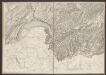
Le Marquisat et Eslectorat De Brandebourg qui fait partie du Cercle de la Haute Saxe, divisé en ses Principales Parties [Karte], in: Atlas nouveau, contenant toutes les parties du monde [...], Bd. 1, S. 327.
1 Karte aus Atlas Sanson, Nicolas Jaillot, Alexis Hubert und Mortier, Pieter
Electoratus Brandenburgi, Mekelenburgi, et maximae partis Pomeraniae novissima tabula
1 : 951400 Braniborsko (Německo) Visscher, Nicolaes Jansz. Nicolaus Vißcher
Charte über den nördlichen Theil des ober saechsischen Kreises enthaltend die Mark Brandenburg u. d. Hrz. Pom[m]ern
1 Karte : Kupferdruck ; 46 x 59 cm Güssefeld im Verlage des Industrie Comptoirs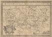
Brandeburgensis Marchae Descriptio. [Karte], in: Theatrum orbis terrarum, S. 233.
1 Karte aus Atlas Ortelius, Abraham Vrients, Jan Baptista