Maps of Ukraine

Imperium Romanum
1 : 11300000 Evropa východní Bonne, Rigobert André
Imperii Romani.
1 : 9850000 Vivien de St Martin, L.
Imperii Romani distracta
1 : 55500000 Asie západní Bonne, Rigobert André
Schauplatz des russisch-türkischen Krieges
1 : 2850000 Evropa východní Anville, Jean-Baptiste Bourguinon d' Schraembl, Franz Anton F. A. Schraembl
Schauplatz des Russisch Türkischen Krieges
1 : 2850000 Evropa východní Anville, Jean-Baptiste Bourguinon d' Schraembl, Franz Anton F. A. Schraembl
Schauplatz des Russisch Türkischen Krieges
1 : 2850000 Balkánský poloostrov Anville, Jean-Baptiste Bourguinon d' Schraembl, Franz Anton F.A. Schraembl
Schauplatz des russisch-türkischen Krieges
1 : 2850000 Evropa východní Anville, Jean-Baptiste Bourguinon d' Schraembl, Franz Anton F. A. Schraembl
Europe 3.
1 : 2800000 Anville, Jean Baptiste Bourguignon d, 1697-1782
Turkey, in Europe and Hungary, from the best authorities.
from Carey's general atlas, improved and enlarged : being a collection of maps of the world and quarters, their principal empires, kingdoms, &c.
Argonautica. [Karte] [Europa.], [Thessalia und Umgebung], [Hellespontus, Phryxeum aequor, et Athamantidis fluenta.] [3 Nebenkarten], in: Theatrum orbis terrarum, S. 538.
1 Karte aus Atlas Ortelius, Abraham Vrients, Jan Baptista
Geschäftsverbindungen und Kupferhandel der Medici 1393-1395
Europa Medici, Bankiers, Fuersten, Italien
[Ethnographische Karte von Europa]
Zweiter Band, enthaltend in vier Abtheilungen die Vertheilung der Organismen: 5. Pflanzen-Geographie, 6. Thier-Geographie, 7. Anthropographie, 8. Ethnographie Humboldt, Alexander von Verlag von Justus Perthes
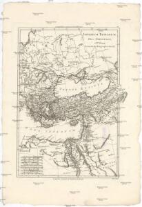
Turcia Asiatica : exhibens Natoliam modernam, in suos beglirbegatus divisam, itemque reliquos beglirbegatus, sive gubernationes et Prœfecturas generales, in regionibus Georgiæ, Armeniæ, Mespotamiæ, Syriæ et Arabiæ sitos, una cum Mari Nigro, Mari Azowiensi, Mari di Marmora, et Mari Ægeo, atque adiacentibus Insulis : C. P. S. C. M. = Carte de la Turquie asiatique contenant la Natolie moderne divisée en les beglerbeys &
1 : 4800000 Homann Erben (Firm) Homannianorum Heredum
Das Osmanische Reich nebst seinen Schutzstaaten nach seiner grössten Ausdehnung 1682
Osmanisches Reich
Carte générale des provinces européennes et asiatiques de l'Empire Ottoman, uit: Carte générale des provinces européennes et asiatiques de l'Empire Ottoman (sans l'Arabie) / dressée par Henri Kiepert ; le trait et la lettre gravés chez L. Kraatz ; le figure du terrain gravé par J. Sulzer
1 : 3000000 Annotatie: Op omslag ook: Deuxième édition entièrement corrigée et augmentée d'un index alphabétique (quatrième édition de la 'Carte générale de l'Empire Ottoman en Europe et en Asie'); Met: Index alfabétique. - 40 p; Annotatie geografische gegevens: Legenda Johann Samuel Heinrich Kiepert 1818-1899; Leopold Kraatz; J. Sulzer Berlin : Dietrich Reimer (Hoefer u. Vohsen) / ([S.l. : L. Kraatz])
Orbis Romani, orientalis.
1 : 11500000 Anville, Jean Baptiste Bourguignon d, 1697-1782; M'Dermut, Robert
Südeuropa
1 : 2500000 Blízký východ Gea Verlag
Übersichts - Karte des Türkischen Reichs in Europa und Asien

Orbis Romani Pars Orientalis.
1 : 10137600 Lucas, Fielding Jr.
Orbis Romani, pars orientalis.
1 : 4300000 Anville, Jean Baptiste Bourguignon d, 1697-1782
Das Osmanische Reich nebst seinen Schutzstaaten nach seiner grössten Ausdehnung 1682
Osmanisches Reich
Tableau historique de l'Empire d'Oriens.
1 : 18500000 Duval, Henri
L'Empire Grec en 1190 et l'Hellenisme pendant l'occupation latine de Constantinople [Hauptkarte]
Byzantinisches Reich Lateinisches Kaiserreich Konstantinopel Hellenismus Kümmerly & Frey
Europa befolkningskarta

Partie orient.le de la mer Méditerranée
1 Karte : Kupferdruck ; 49 x 55 cm Robert de Vaugondy chés l'auteur quay de l'horloge du Palais près le pont neuf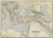
General-Karte des Türkischen Reiches in Europa und Asien nebst Ungarn, Südrussland, den kaukasischen Ländern und West-Persien
1 : 3000000 entworfen und bearb. von Heinrich Kiepert Stich und Druck der lithographischen Anstalt von L. Kraatz Berlin : Reimer
Eastern part of the mediterranean sea with the coasts of Turky Anatolia Syria Egypt and Barbary
1 Blatt : 53 x 68 cm Sayer
La mer Mediterranée vers l'orient
1 Karte : Kupferdruck ; 38 x 49 cm Duval P. Duval
Balkánské státy a Turecko
1 : 3000000 Bospor (Turecko : průliv) Paulík, Ant. Klus, František Ústřední učitelské nakladatelství a knihkupectví