Maps of Libyan Desert

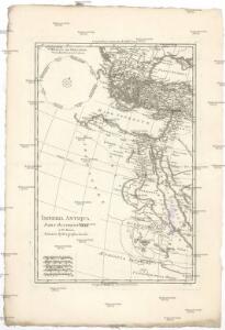
Imperia antiqua
1 : 13530000 Afrika severní Bonne, Rigobert André
Ooster Deel der Middelantse-Zee [Karte in 2 Teilen] Golf Van Constantinopoley [Nebenkarte], in: De Nieuwe Groote Vermeerderde Zee-Atlas ofte Water-Werelt, S. 53.
1 Karte aus Atlas Doncker, Hendrick
[Afrika, Blatt 2]
Adolf Stieler's Handatlas über alle Theile der Erde und über das Weltgebäude Stieler, Adolf Justus Perthes
Orbis Homeri. 900? Ante Chr.
Mittelmeerraum Homerus
Regna succesorum Alexandri Magni
1 : 9400000 Asie jihozápadní Spruner, Karl von Alt, Wilhelm Justus Perthes
Vorderer Orient
Tableau historique de l'Empire d'Oriens.
1 : 18500000 Duval, Henri
Peregrinationis Divi Pauli Typus Corographicus. [...] [Karte], in: Theatrum orbis terrarum, S. 441.
1 Karte aus Atlas Ortelius, Abraham Vrients, Jan Baptista
Türkey
Allgemeiner Atlas [Walch, Johannes] im Verlag bei Johannes Walch
Carte patriculiére des pais ou les apôtres ont preché l'euangile, des lieux les plus renommez de leurs voyages, et de la route de St. Paul a Rome
Středozemní moře-oblast Luchtenburg, I. van Mortier, Pieter Pierre Mortier
Tabula Africae III. [Karte], in: Claud. Ptolemaeus. Geographia lat. cum mappis [...], S. 290.
1 Karte aus Atlas Münster, Sebastian [und Ptolemaeus, Claudius]
Das osmannische Reich, XVIIten Jahrhundert.
1 : 9200000 Spruner von Merz, Karl
Karte der griechischen Welt
Evropa jižní F. Tempsky
Tabula Africae III. [Karte], in: Geographia universalis vetus et nova complectens Claudii Ptolemaei Alexandrini enarrationis libros VIII, S. 260.
1 Karte aus Atlas Münster, Sebastian [und Ptolemaeus, Claudius]
Tableau l'historie de l'Empire des Califes et de l'Empire de Turquie.
1 : 20000000 Duval, Henri
Osmanisches Reich und seine Schutzstaaten im XVIIten Jahrhundert
1 : 9000000 Osmanisches Reich Protektorat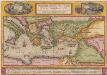
Peregrinationis Divi Pauli Typus Corographicus [...] [Karte], in: Theatrum orbis terrarum, S. 442.
1 Karte aus Atlas Ortelius, Abraham
Levante Dienst
Středozemní moře-oblast východní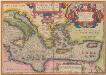
Aeneae Troiani Navigatio Ad Virgilii Sex priores Aeneidos. [Karte], in: Theatrum orbis terrarum, S. 448.
1 Karte aus Atlas Ortelius, Abraham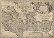
Aeneae Troiani Navigatio Ad Virgilii Sex priores Aeneidos. [Karte], in: Theatrum orbis terrarum, S. 532.
1 Karte aus Atlas Ortelius, Abraham Vrients, Jan Baptista
Orientalior districtus Maris Mediterranei
1 Karte : Kupferdruck ; 47 x 58 cm Renard apud L. Renard
Orbis Romani pars orientalis, auspiciis serenissimi principis Ludovici Philippi Aurelianorum ducis publici juris facta
1 : 4300000
[Des Mittelländischen Meeres öestliches Blatt. Zur Uebersicht des Türkischen Reichs und als Pecial-Karte der Asiatischen u. Afrikanischen Türkey]
Stieler's Hand-Atlas Stieler, Adolf bei Justus Perthes
Regni Hungariae Graeciae Moreae Totuis Danubii, Adiacentiumque Regnorum, Nec Non Totius Graeciae et Archipelagi Delineatio nova expressa
1 : 3800000 Mollova mapová sbírka Schenk, Pieter Schenk, Peter II
Regni Hungariae, Graeciae et Moreae
1 : 4000000 Mollova mapová sbírka Danckerts, Justus Danckerts, Danker Danckerts, Justus
Orbis Romani, orientalis.
1 : 11500000 Anville, Jean Baptiste Bourguignon d, 1697-1782; M'Dermut, Robert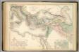
Principal Countries of the Ancient World.
1 : 7100000 Hughes, William
Das türkische Reich
Afrika severní
[134][137] Orientalior districtus Maris Mediterranei ..., uit: Atlas sive Descriptio terrarum orbis
Annotatie: Gedigitaliseerde versie. Amsterdam. Heiloo : Picturae (vervaardiger), 2015. tiff-bestand. Gedigitaliseerd: 07-01-2015; Origineel: Universiteitsbibliotheek Vrije Universiteit (XL.05127.-) ; Netherlands; Titelpagina ontbreekt Wit, Frederik de Amsterdam : Frederick de Wit