Maps of Veneto
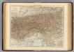
Karte von Tirol, Steyermark und Illyrien
1 : 1174000 Ilýrie Fried, Franz Rothenburg, Friedrich Rudolf von Artaria et Comp.
Ost-Alpenländer
Neuer Handatlas über alle Theile der Erde Kiepert, Heinrich Verlag von Dietrich Reimer
Bez titulu: Slepá hydrografická mapa jihovýchodní Evropy

Der südwesten der Österreichis - ungarischen Monarchie mit den angrenzenden Gebieten

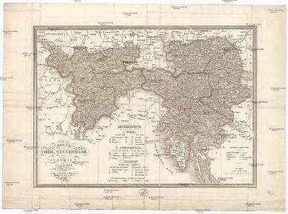
Kärnten, Krain, Steiermark, Tirol und Vorarberg
1 : 1750000 Korutansko (Rakousko) F.A. Brockhaus' geogr.-artist. Anstalt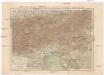
Korutany, Krajina, Salcbursko, Štýrsko, Tyrolsko a Vorarlbersko
Korutansko (Rakousko) Köb, Kajetano Luther, Th. nákladem J. Otty
Süd-Östliches Deutschland
Stieler's Hand-Atlas Stieler, Adolf bei Justus Perthes
Oesterreich, Süd Westlicher Theil
Handatlas über alle Theile der Erde und über das Weltgebäude Stieler, Adolf Justus Perthes
[Süd-Östliches Deutschland]
Hand-Atlas über alle Theile der Erde nach dem neuesten Zustande und über das Weltgebäude Stieler, Adolf bei Justus Perthes
[Süd-Östliches Deutschland, Erzherzogth. Oesterreich, Tirol, Illyrien, Steyermark]
Hand-Atlas über alle Theile der Erde nach dem neuesten Zustande und über das Weltgebäude Stieler, Adolf bei Justus Perthes
Severovýchodní Italie a alpské země rakouské s Přímořím, Istrii [sic] a Chorvatskem
1 : 1000000 Alpy rakouské-oblast Emil Šolc

Neue Karte von den franzoesischen Kriegs-Schauplatze in Ober und Mittel Italien, Tyrol, Friaul, Krain, Kaernthen, Steyermark etc
1 : 1720000 Furlandsko
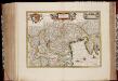
Dominio Veneto Nell' Italia. [Karte], in: Le théâtre du monde, ou, Nouvel atlas contenant les chartes et descriptions de tous les païs de la terre, Bd. 3, S. 84.
1 Karte aus Atlas Blaeu, Willem Janszoon und Blaeu, Joan Blaeu, Willem Janszoon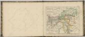

Dominio Veneto Nell Italia. [Karte], in: Theatrum orbis terrarum, sive, Atlas novus, Bd. 3, S. 82.
1 Karte aus Atlas Blaeu, Joan Blaeu, Willem Janszoon
Dominio Veneto Nell' Italia. [Karte], in: Novus Atlas, das ist, Weltbeschreibung, Bd. 3, S. 96.
1 Karte aus Atlas Blaeu, Joan Blaeu, Willem Janszoon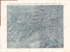
Plastická mapa severovýchodní Italie a Alpských zemí rakouských s Přímořím a Istrií

Die Ostalpenländer
1 : 2750000 Alpenländer Skizzenbuch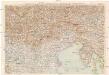
G. Freytags Karte des Österreichisch-italienischen Grenzgebietes
1 : 600000 Benátské Alpy (Itálie) Freytag, Gustav G. Freytag & Berndt
Dominium Venetum In Italia. [Karte], in: Novus atlas absolutissimus, Bd. 5, S. 21.
1 Karte aus Atlas Janssonius Offizin
Dominium Venetum In Italia [Karte], in: Gerardi Mercatoris et I. Hondii Newer Atlas, oder, Grosses Weltbuch, Bd. 2, S. 237.
1 Karte aus Atlas Mercator, Gerhard und Hondius, Jodocus Jansson, Jan
[Oesterreich, Tyrol mit Vorarlberg. Steyrmark und Illyrien]
Schul-Atlas in 36 Karten Völter, Daniel Verlag der J.M. Dannheimer'schen Buchhandlung
Nr. 10 a. Italien: Der Krieg
Italien Weltkrieg <1914-1918>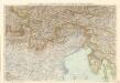
G. Freytags Karte des Österreichisch-Italienischen Grenzgebietes
Dominivm Venetvm in Italia
1 : 850000 Annotatie: Origineel is Blad 158 in atlas factice; Annotatie geografische gegevens: Schaalstokken op kaart: 28 Milliaria Italica Communia (= 5,5 cm), en: 7 Milliaria Germanica Communia (= 5,2 cm) Amstelodami : Apud Ioannem Ianssonium
Cercle D'Autriche divisé en toutes ses Provinces, tant Civiles qu'Ecclésiastiques
Brion de la Tour, Louis Desnos
Generalcharte von Oesterreich, Tyrol, Steyermark und Illyrien
1 : 1600000 Horní Rakousko (Rakousko) Schönberg, Johann bey Johann Schönberg