Maps of Porajów
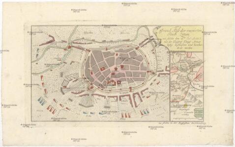
Grund-Riss der ruinirten Stadt Zittau
Žitava (Německo) in der Raspischen Buchhandlung
Die Statt Zittaw in Ober Lausitz, wie sie A°. 1632 vom Obr. Bolzen fortificirt worden, sampt der Belägerung A°. 1643
Žitava (Německo) Pezold, Daniel Mentzel, J. G.
Plan von Zittau

[Kartenblatt]
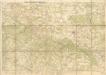
1 : 25000 Varnsdorf (Česko : oblast) Reichsamt für Landesaufnahme
Das böhmisch-sächsische Grenzgebirge
Lužická Nisa-oblast lith. Kunstanstalt von Ed. Strache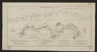
Karte der Löbau-Zittauer Eisenbahn
1 : 57000 Lith. v. F.A. Renner
Rumburg und Warnsdorf
1 : 75000 Rumburk (Česko : oblast) Lampe K. u. k. militär-geographisches Institut
Rumburg und Warnsdorf
1 : 75000 Rumburk (Česko : oblast) Lampe K. u. k. Militärgeographisches Institut
Rumburg und Warnsdorf
1 : 75000 Rumburk (Česko : oblast) K. u. k. Militärgeographisches Institut
III. vojenské mapování 3653
1 : 75000
Varnsdorf
1 : 75000 Varnsdorf-oblast (Česko) Vojenský zeměpisný ústav
Vilímkovy místopisné mapy zemí Koruny české
1 : 100000 Frýdlant (Česko : oblast) Srp, Jan Jos. R. Vilímek
Podrobná mapa Království českého
1 : 100000 Frýdlant (Česko : oblast) Srp, Jan Jos. R. Vilímek
Section Zittau

Soubor přehledných map pro plánování a statistiku: Šluknov 3553

Karte des Bezirkes Deutsch-Gabel
1 : 75000 Jablonné v Podještědí-oblast (Česko) Stelzig, Heinrich Freier Lehrervereinim Schulbezirke Deutsch-Gabel
[Umgebung von Gabel]
1 : 78000 Jablonné v Podještědí-oblast (Česko) Kreibich, František Jakub Jindřich
Soubor přehledných map pro plánování a statistiku: 3553 – Šluknov

Mapa okresních hejtmanství Libereckého a Jabloneckého
Umgebungen von Reichenberg
1 : 144000 Liberec-oblast (Česko) Baur, A. K. u. k. Militärgeographisches Institut
Special - Karte des Koenigreiches Boehmen

Rumburg und Warnsdorf.
from Spezialkarte der osterreichisch-ungarischen Monarchie.
Generální mapa okresních hejtmanství

Reichenberg u. Friedland.
from Spezialkarte der osterreichisch-ungarischen Monarchie.
Umgebungskarte zu Woerl's Führer
1 : 220000 Liberec-oblast (Česko) Woerl's Reisebücherverlag
II. vojenské mapování 3
1 : 144000
II. vojenské mapování 3
1 : 144000
Generální mapa okresních hejtmanství