Maps of Northwest
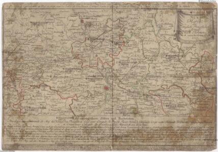
March der königlich-preussischen Armée nach Böhmen in 4. verschiedenen Corps 1757
Česko Friedrich, Jacob Andreas Jacob Andreas Friedrich
[Sudety]
1 : 1120000 Sudety (Česko) Národní jednota severočeská
Mapa války 1778-1779

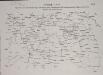
Position des toute les deux armée en Bohéme de l'anne 1778 depuis le 5. juin jusq' au 10. aout
Česko
Mapa války 1778-1779
1 : 1600000
Bohmen.
1 : 675000 Weiland, C. F. (Carl Ferdinand), d. 1847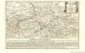
March Königlich-Preussischen Armée nach Böhmen in 4. verschiedenen Corps 1757
Mollova mapová sbírka Fridrich, Jacob Andreas Fridrich, Jacob Andreas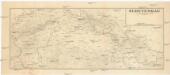
Sudetengau
1 : 600000 Protektorát Čechy a Morava Landesplanungsgemeinschaft Sudetengau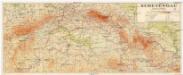
Sudetengau
1 : 600000 Protektorát Čechy a Morava Sudetendeutsche Anstalt für Landes- und Volksforschung
Post Charte vom Königreiche Böhmen.verlegt im Jahr 1802
mapa VKOL s.n.]
Přehledná mapa střední Evropy
1 : 500000 Sasko (Německo) Vojenský zeměpisný ústav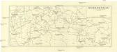
Sudetengau
1 : 1000000 Čechy (Česko) Landesplanungsgemeinschaft Sudetengau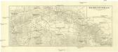
Sudetengau
1 : 1000000 Čechy (Česko) Landesplanungsgemeinschaft Sudetengau
Eisenbahn - Routen - Karte von Mittel - Europa

Sídliště pokolení skrčených koster v Čechách
Čechy (Česko)
Hroby se skrčenými kostrami v Čechách
Čechy (Česko)
Mappa Geographica Totius Regni Bohemiae in XII. Provincias divisae adjunctis Comitatu Glacensi Regione Egrana et Limitibus finitimarum Provinciarum
1 : 650000 Mollova mapová sbírka Gütl, Philipp
Mappa Geographica Totius Regni Bohemiae in XII. Provincias divisae adjunctis Comitatu Glacensi Regione Egrana et Limitibus finitimarum Provinciarum.
1 : 650000 Mollova mapová sbírka Gütl, Philipp Gütl, Philipp
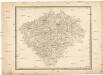
Mappa Geographica Totius Regni Bohemiae in XII. Circulos divisae
1 : 685000 Mollova mapová sbírka Lotter, Tobias Conrad Lotter, Tobias Conrad
Regni Bohemiae in duodecim Circulos divisae cum Comitatu Glacensi et Districtu Egerano Conspectus Generalis cujus Sectiones XXV
1 : 680000 Mollova mapová sbírka Müller, Johann Christoph Kauffer, Michael Müller, Johann Christoph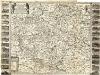
Bohemia in suas partes geograph. distinc
1 : 512000 Mollova mapová sbírka Sandrart, Jakob von Sandrart, Jacob von
Evanjelická cirkev [sic] česká
Čechy (Česko) Gräf, K. Müller, A.
Copia ab antiquissima Mappa Regni Bohemiae
Operationen des österreichischen Corps unter Harsch, später unter General de Ville, und der preussischen Truppen unter General Fouqué, vom 17ten bis 29ten Juli
[Čechy]
Česko
Detail-Operations-Karte für den Krieg in Böhmen 1866
1 : 290000 Česko
Leipzig - Kohlfurth - Pardubitz

Boehemer Koenigreich mit Bergen und Waelden gerings umb beschlossen
1 : 925000 Česko Münster, Sebastian Klaudyán, Mikuláš
Boehemer koenigreich mit Bergen und Waelden gerings umb beschlossen
1 : 900000 Česko Klaudyán, Mikuláš Münster, Sebastian