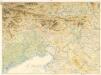
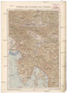
Maps of Slovenia

Přehledná mapa slovinských zemí s Přímořím
1 : 750000 Chorvatsko Machát, František
Illyrien.
1 : 880000 Radefeld, Carl Christian Franz, 1788-1874
General-Karte des Königreichs Yllyrien
1 : 295000 Ilýrie
General-Karte des Königreichs Jllyrien
1 : 295000 Ilýrie im k.k. Militaerischen geographischen Institute
Königreich Illyrien
Grosser Hand-Atlas über alle Theile der Erde in 170 Karten Meyer, J. Verlag des Bibliographischen Instituts

Karstia, Carniola, Histria et Windorum Marchia. [Karte], in: Le théâtre du monde, ou, Nouvel atlas contenant les chartes et descriptions de tous les païs de la terre, Bd. 1, S. 233.
1 Karte aus Atlas Blaeu, Willem Janszoon und Blaeu, Joan Blaeu, Willem Janszoon
Tabula DUCATUS CARNIOLIAE VINDORUM MARCHIAE et HISTRIAE
1 : 520000 Cirknické jezero (Slovinsko) Homann, Johann Baptist Valvasor, Janez Vajkard â Io. Bapt. Homanno
Tabula ducatus Carnioliae Vindorum Marchiae et Histriae
1 : 510000 Cirknické jezero (Slovinsko) Homann, Johann Baptist Valvasor, L. B. â Io. Bapt. Homanno
Karstia, Carniola et Windorum Marchia cum confinys. Per Gerardum Mercatorem cum privilegio
1 : 750000 Krain, Istrien Mercator, Gerhard, der Jüngere

Ducatus Carnioliae tabula
1 : 648000 Istrijský poloostrov (Slovinsko a Chorvatsko) Granelli, Carlo Engelbrecht, Christian C. E. et I.A. P.
Ducatus Carintiae et Carnioliae Cilleiaeque Comitatus
1 : 600000 Mollova mapová sbírka Wit, Frederik de Mortier, Pierre
Karstia, Carniola, Histria et Windorum Marchia
Krain, Friaul Mercator, Gerhard, der Jüngere ; Blaeu, Willem Janszoon

Goritiae, Karstii, Chaczeolae, Carniolae, Histriae, Et Windorum Marchae Descrip. [Karte], in: Theatrum orbis terrarum, S. 186.
1 Karte aus Atlas Ortelius, Abraham
Karstia Carniola Histria et Windorvm Marchia
1 : 850000 Mollova mapová sbírka Merian, Matthaeus Merian, Caspar - dědici
KARSTIA, | CARNIOLA,| HISTRIA | et | WINDORVM | MARCHIA
Ger. Mercatore | Auctore. Guiljelm. Blaeu | excudit
Goritiae, Karstii, Chaczeolae, Carniolae, Histriae, Et Windorum Marchae Descrip. [Karte], in: Theatrum orbis terrarum, S. 281.
1 Karte aus Atlas Ortelius, Abraham Vrients, Jan Baptista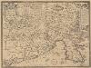
Fori Iulii Accurata Descriptio. [Karte], in: Theatrum orbis terrarum, S. 287.
1 Karte aus Atlas Ortelius, Abraham Vrients, Jan Baptista
Königreich Illyrien Charte des gouvernements Triest
1 : 450000 Ilýrie Renner A. Plott
Fori Iulii Accurata Descriptio. [Karte], in: Theatrum orbis terrarum, S. 192.
1 Karte aus Atlas Ortelius, Abraham
Ducatus Carnioliae accuratissima Delineatio per
1 : 670000 Mollova mapová sbírka Weigel, Christoph Köhler, Johann David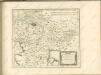

Ducatus Stiriae et Carintiae Carniolae Cilleiae q; Comitatus, Nova Tabula que et Paris est Meridionalior Circuli Austriaci
1 : 910000 Mollova mapová sbírka Ottens, Reinier Ottens, Josua
Goritiae, Karstii, Chaczeolae, Carniolae, Histriae, et Windorvm marchae descrip
1 Karte : Kupferdruck ; 31 x 23 cm Lazius; Ortelius s.n.
Goritiae, Karstii, Chaczeolae, Carniolae, Histriae, et Windorvm marchae descrip
1 Karte : Kupferdruck ; 31 x 23 cm Lazius; Ortelius s.n.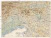
Oestl. Dolomiten, Karnische- u. Julische Alpen, Görz, Küstenland, Friaul und oberitalienische Venezianische Ebene
1 : 250000 Benátky-oblast (Itálie) geographischen Anstalt von L. Ravenstein
Slovenia & NW Croatia, MDR Misc 8802
Slovenia & NW Croatia, MDR Misc 8802. To accompany GSI(Top.) Report on the Roads of Yugoslavia, Part XIII. Great Britain. Army. Royal Engineers. Map Reproduction Section, 17th. [Cairo] : [Survey Directorate, Middle East]