Maps of Europe
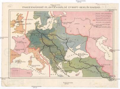
Pangermánský plán centrální Evropy - Berlín-Bagdad
Bagdád (Irák)
[Hierographie, oder topographisch-synchronistische Darstellung der Geschichte der christlichen Kirche] : VIII. Von Carl d. G. bis auf Gregor VII vom Jahr 800-1073
1 : 8400000 W.A. Möller Lith. bey Arnz & Co. in Düsseldorf Elberfeld : Büschler
Evropa v polovině XVI. stol. (okolo r. 1560)
1 : 19350000 Evropa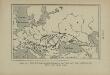
Carte de l’émigration des Sauromates, du 5e siècle au 1er siècle avant notre ère
Ostmitteleuropa Sarmaten Völkerwanderungszeit Völkerwanderung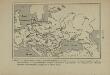
Carte du monde slave et du monde germanique à la fin du 5e siècle de notre ère, après la dispersion des Huns
Europa Slawen Germanen Bevölkerung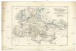
Uebersichts-Karte für die Zeit nach dem zweiten pariser Frieden
Evropa Loewenberg, Julius Herder, B.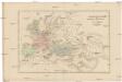
Uebersichts-Karte für die Geschichte von der Völkerwanderung bis auf Carl den Grossen
Evropa Loewenberg, Julius Herder, B.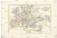
Uebersichts-Karte für das Zeitalter Napoleon's
Evropa Loewenberg, Julius Herder, B.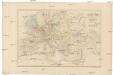
Uebersichts-Karte für die Geschichte von der Reformation bis zum westphälischen Frieden
Evropa Loewenberg, Julius Herder, B.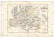
Uebersichts-Karte für der Carls des Grossen bis zum Ende der Kreuzzüge
Evropa Loewenberg, Julius Herder, B.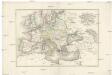
Uebersichts-Karte für die Zeit vom westphälischen Frieden bis zur französischen Revolution 1789
Evropa Loewenberg, Julius Herder, B.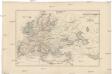
Uebersichts-Karte für die Geschichte vom Ende der Kreuzzüge bis zur Reformation
Evropa Loewenberg, Julius Herder, B.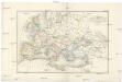
Uebersichts-Karte der nach der Völkerwanderung entstandenen neuen Reiche
Evropa Loewenberg, Julius Herder, B.
Atlas für Handel und Industrie: Für Kaufleute, Fabrikante u. Gewerbetreibende, Handlungs- u. Gewerbe-Schulen

Atlas für Handel und Industrie: Für Kaufleute, Fabrikante u. Gewerbetreibende, Handlungs- u. Gewerbe-Schulen
Evropa po IV. křižácké výpravě (okolo r. 1220)
1 : 19350000 Evropa
Carte des peuples slaves (Wendes ou Venèdes) établis en Europe, selon de Tacite, au 1er siècle de notre ère, savoir: Aries, Naharvalles, Roxolans, Jazyges, Lugiens, Marimes, Vénèdes, Helvécones, Elysies, Peucins. Les autres peuples indiqués sur cette carte sont germains ou finnois
Mitteleuropa Wenden Völkerwanderungszeit Tacitus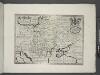
Hungary, Transylvania, Poland, &c.
from A new sett of maps both of antient and present geography : wherein not only the latitude and longitude of many places are corrected according to the latest observations, but also the most remarkable differences of antient and present geography may be quickly discern'd by a bare inspection or comparing of correspondent maps, which seems to be the most natural and easy method to lead young students (for whose use the work is principally intended) unto a competent knowledge of the geographical science : together with a geographical treatise particularly adapted to the use and design of these maps / by Edward Wells, M.A. and student of Christ-Church, Oxon.
Carte de la répartition des peuples slaves, germaniques, finnois ou hunniques, au milieu du 6e siècle de notre ère, vers l’an 560
Europa Völkerwanderung Völkerwanderungszeit ethnische Gruppe
Europe sous Charlemagne.
1 : 20500000 Monin, C.V.
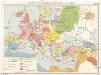
Völkerkarte von Europa
1 : 23500000 Europa Ethnische Gruppe
[Hierographie, oder topographisch-synchronistische Darstellung der Geschichte der christlichen Kirche] : X. Von Gregor VII bis zu den Päpsten in Avignon 1073-1305
1 : 8400000 W.A. Möller Lith. bey Arnz & Co. in Düsseldorf Elberfeld : Büschler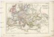
Europa zur Zeit Carl's V
Evropa
Die Posten Welt oder der Theil der Erde, auf welchem ordentliche Posten Laufen
Evropa Kühn, I. zu finden im von Reilly'schen Landkarten und Kunstwerke Verschleiss Komtoir
Europa's letzte fünfundzwanzig Jahre 1815-1840 zur Uebersicht der Geschichte der neuesten Zeit
Balkánský poloostrov Loewenberg, Julius Silber v. J.J. Weber
Di-gyiu Du, Ng Da-tsiu Di-du[地舆图、五大洲地图]
Di-gyiu Du, Ng Da-tsiu Di-du[地舆图、五大洲地图] 1853年,Martin, W. A. P. (William Alexander Parsons) 美国长老会传教士丁韪良用罗马拼音标注宁波方言编写的世界地理著作,对地球和各大洲进行介绍。内有东西半球图、亚洲图、欧洲图、非洲图、北美洲图、南美洲图、地中海附近图、清内地十八省图、浙江省图、宁波附近图等。 10图,墨刻本,罗马拼音标注宁波方言,图幅不一,约39 x 49.5 cm Harvard-Yenching | Rare Book | TA 2370 92,Hollis Number:008156153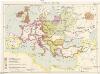
Evropa v IX. stol
1 : 19350000 Evropa
[Hierographie, oder topographisch-synchronistische Darstellung der Geschichte der christlichen Kirche] : XII. Von den Päpsten in Avignon bis zur Reformation J. 1305-1517
1 : 8400000 W.A. Möller Lith. bey Arnz & Co. in Düsseldorf Elberfeld : Büschler
[Hierographie, oder topographisch-synchronistische Darstellung der Geschichte der christlichen Kirche] : XI. Von den Päpsten in Avignon bis zur Reformation 1305-1517
1 : 8400000 W.A. Möller Lith. bey Arnz & Co. in Düsseldorf Elberfeld : Büschler