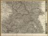
Maps of Khotyn Raion
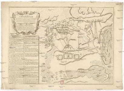
Plan batalii pri Stavučanach v Moldavii, meždu imperatorskoju rossiskoju glavnoju armějeju pod komandoju generala feldtmaršala grafa fon Minicha i meždu tureckoju armějeju, pod komandoju Seraskera trech bunčužnago Veli paši i saltana Islam Girěi, byvšen 17/28 augusta 1739 godu
1 : 40000
Czernowitz.
from Spezialkarte der osterreichisch-ungarischen Monarchie.
Czernowitz
1 : 75000 Ukrajina Leixner, F. K. u. k. Militärgeographisches Institut

Ost-Galizien
Halič (Polsko a Ukrajina) Liesganig, Joseph im Verlage des Kunst und Industrie Comptoirs
Czernowitz
1 : 400000 Instytut wojskowo-geograficzny
Bukowina oder oestreich'scher Antheil der Moldau
1 : 580000 Bukovina (Rumunsko a Ukrajina) Küstel, Aloys J. Mare, Carl Gleditsch
G. Freytags Karte der Bukowina
1 : 400000 Bukovina (Rumunsko a Ukrajina) Freytag, Gustav Kartogr. Anstalt G. Freytag & Berndt
G. Freytags Karte der Bukowina
1 : 400000 Bukovina (Rumunsko a Ukrajina) Freytag, Gustav G. Freytag & Berndt
Carte de la Moldavie
1 : 330000 Moldawien, Bessarabien
Neue Generalkarte des Österr.-ungar.-russischen Kriegsschauplatzes

[Bodolien, Moldawien]
1 Karte : Kupferdruck ; 18 x 13 cm [Trattner]
Ukrainae pars, quae Podolia palatinatus vulgo dicitur / per Guil. le Vasseur de Beauplan s. r. m.tis
1 : 420000 1 Karte : Kupferdruck ; 43 x 52 cm Beauplan, Guillaume le Vasseur de [Verlag nicht ermittelbar]
Russia
Mollova mapová sbírka Hoffmann, Johannes Hoffmann, Johann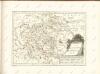
Nr. 6b. Kämpfe in Ostgalizien. Im Dnjestrgebiet
Galizien Weltkrieg <1914-1918>, Ostfront
Tarnopol, Brody, Stryj, Czernowitz
1 : 750000 Brody (Ukrajina) Erben, F. K. u. k. Militärgeographisches Institut
Tarnopol, Brody, Stryj, Czernowitz
1 : 750000 Brody (Ukrajina) Erben, F. K. u. k. Militärgeographisches Institut
Tarnopol, Brody, Stryj, Czernowitz
1 : 750000 K. u. k. militär-geographisches Institut
Tarnopol, Brody, Stryj, Czernowitz
1 : 750000 Brody (Ukrajina) K. k. militär-geographisches Institut

Carte de la Roumanie et pays limitrophes. Lemberg
1 : 500000 France. Service géographique de l'armée [Paris] : Service géographique de l'armée
Mappa generalis regni Hungariae partiumque adnexarum Croatiae, Slavoniae...

Galizien, Östlicher Theil und Bukowina
1 : 700000 Bukovina (Rumunsko a Ukrajina) Karl Fr. Pfau
Sheet X: Karte Des Oesterreichischen Kaiserstaates.
1 : 576000 Scheda, Josef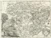
Moldavia.
1 : 1800000 Mollova mapová sbírka Bruggen, Johann van der Brugge, Johannes van der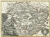
Moldavia
1 : 1800000 Mollova mapová sbírka Pfeffel, Johann Andreas
X, uit: General-Karte des oesterreichischen Kaiserstaates mit einem grossen Theile der angrenzenden Länder / durch Josef Scheda ... bearb. und hrsg
1 : 576000 Annotatie geografische gegevens: Maatstokken: oesterreichische Meilen, geografische oder deutsche Meilen, preussische Meilen, türkische Berri, französische Lieues, russische Werste; Maatstok per blad: wiener Klafter, öster. Meilen; Blad XIX: statistische en taalkundige informatie; Blad XIX: legenda [Wien : K.K. Militärisch-Geografisches Institut]
Übersichtskarte von Mittel - Europa