Maps of Flemish Region

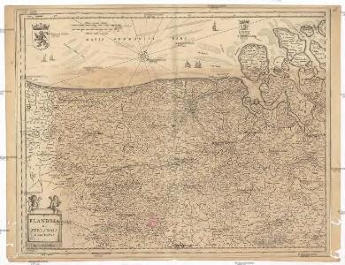
Flandria et Zeelandia comitatvs
1 : 350000 Flandry Blaeu, Willem Janszoon apud Guiljelmum Blaeuw
Carta generale de Paesi Bassi terzo foglio che comprende la Contea di Zelanda, porzione di quella di Olanda, la Contea di Flandria, parte del Ducato di Brabante, il Marchesato d'Anversa, e la Signoria di Malines
1 : 570000 Gio. Ma. Cassini Som. inc. Roma : presso la Calcografia Camerale
Comitatus Flandriae Nova Tabula. [Karte], in: Novus atlas absolutissimus, Bd. 3, S. 106.
1 Karte aus Atlas Janssonius Offizin
FLANDRIA | ET | ZEELANDIA | COMITATVS.
Apud Guiljelmum Blaeuw.
FLANDRIA | ET | ZEELANDIA | COMITATVS.
Apud Guiljelmum Blaeuw.

Flandriae comitauts in sua stoparchias optimé distinctus, uná cum vicinis et finitimis
1 : 330000 Flandry Schenk, Pieter Petr Schenck
Flandria. [Karte], in: Theatrum orbis terrarum, S. 48.
1 Karte aus Atlas Ortelius, Abraham
[Belgie a Nizozemí]
Belgie Schraembl, Franz Anton F.A. Schraembl
Caarte van T'Graafschap Vlaanderen :
1 : 250000 Mollova mapová sbírka Delisle, Guillaume
Flandriae Comitatus
1 : 166000 Mollova mapová sbírka Schenk, Pieter Schenk, Peter I

Flandriae Comitatus Accuratissima Descriptio [Karte], in: Novus atlas absolutissimus, Bd. 3, S. 109.
1 Karte aus Atlas Janssonius Offizin
Paskaert vande Zeeuse Vlaemse en Engelse Kusten [nordöstliche Küste] [Karte], in: De Nieuwe Groote Vermeerderde Zee-Atlas ofte Water-Werelt, S. 35.
1 Karte aus Atlas Doncker, Hendrick
[105][108] Comitatus Flandriae tabula, uit: Atlas sive Descriptio terrarum orbis
Annotatie: Gedigitaliseerde versie. Amsterdam. Heiloo : Picturae (vervaardiger), 2015. tiff-bestand. Gedigitaliseerd: 07-01-2015; Origineel: Universiteitsbibliotheek Vrije Universiteit (XL.05127.-) ; Netherlands; Titelpagina ontbreekt Wit, Frederik de Amsterdam : Frederick de Wit
Ausfluss der Schelde in die Nord-See
1 : 500000 Nizozemsko Adam, Jakob Artaria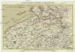
Ausfluss der Schelde in die Nord-See
1 : 500000 Nizozemsko Adam, Jakob Artaria Comp.
Flandriae Comitatus Descriptio. [Karte] [Walcheren. Borsele. Suitbeverlandt.] [Nebenkarte], in: Theatrum orbis terrarum, S. 186.
1 Karte aus Atlas Ortelius, Abraham Vrients, Jan Baptista
Flandria
1 : 600000 Mollova mapová sbírka Mercator, Gerhard
Nouvelle carte de la province de Zélande
1 : 115000 dressée et gravée par C. van Baarsel et fils. A La Haye : chez F.J. Weygand, marchand de cartes-geographiques de S.M. le Roi des Pays-Bas
Flandriae Comitatus accuratissima descriptio
1 : 320000 edita per Nicolaum Visscher. 't Amsteldam : by Nicolaes Visscher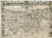
Comitatus Flandria
1 : 440000 Mollova mapová sbírka Visscher, Claes Jansz. Visscher, Claes Janszoon
Flandriae Comitatus
1 : 290000 Mollova mapová sbírka Visscher, Nicolaes Jansz. Visscher, Nicolaus II.
Le Comte de Flandre
1 : 300000 Mollova mapová sbírka Tralage, Jean-Nicolas de Nolin, Jean Baptiste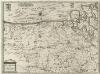
Flandria et Zeelandia Comitatvs
1 : 310000 Mollova mapová sbírka Blaeu, Willem Janszoon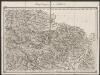
Flandria Comit: [Karte], in: Gerardi Mercatoris Atlas, sive, Cosmographicae meditationes de fabrica mundi et fabricati figura, S. 290.
1 Karte aus Atlas Mercator, Gerhard Montanus, Petrus
North West Europe: front line, June 27th, 1916, from Nieuport to Lens
1 : 250000 First World War map of North West Europe. Front line, June 27th, 1916, from Nieuport to Lens. War Office
Le Comté De Flandre Devisé En Ses Chastellenies et Balliages, &c. Le Franc De Bruges et Le Pays De Waes Dedié Au Roy [Karte], in: Atlas nouveau, contenant toutes les parties du monde [...], Bd. 2, S. 50.
1 Karte aus Atlas Sanson, Nicolas Jaillot, Alexis Hubert und Mortier, Pieter
Flandria maximus et pulcherrimus Europae comitatus
1 : 310000 Flandry Seutter, Matthäus