Maps of Denmark

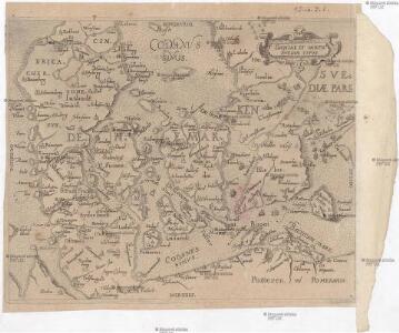
Daniae et partis Svediae typvs
Dánsko
Daniae regnum cum ducatu Holsatiae et Slesvici, nec non insulae Danicae, et Iutia cum parte Scaniae
1 : 950000 Dánsko Seutter, Matthäus studio Matthaei Seutteri
Daniae regnum cum ducatu Holsatiae et Slesvici, nec non insulae Danicae, et Iutia cum parte Scaniae
1 : 950000 Dánsko Seutter, Matthäus studio Matthaei Seutteri
Daniae regnum cum ducatu Holsatiae et Slesvici, nec non insulae Danicae, et Iutia cum parte Scaniae
1 : 950000 Dánsko Seutter, Matthäus studio Matthaei Seutteri
Daniae Reg. cum Ducatu Holsatiae et Slesvici
1 : 500000 Weyerman, Jacob Campo
Daniae regnum cum ducatu Holsatiae et Slesvici nec non insulae Danicae et Iutia cum parte Scaniae
1 : 941000 Dánsko Lotter, Tobias Conrad studio Tobiae Conradi Lotteri
Danemark, Schleswig, Holstein u. Lauenburg, Nebst Den Danischen Colonie'n.
1 : 1500000 Petermann, A.
Homannův atlas světa
1 : 930000
Charte des Königreichs Daenemark, nach Murdochischer Projection und nach den trigonometrischen Charten der König
1 : 919000

Dänemark, Schleswig, Holstein u. Lauenburg, nebst den Dänischen Colonien
Hand-Atlas über alle Theile der Erde und über das Weltgebäude Stieler, Adolf Justus Perthes

[Dänemark und die Dänischen Kolonien]
Handatlas über alle Theile der Erde und über das Weltgebäude Stieler, Adolf Justus Perthes
Daenemark, Island.
1 : 875000 Weiland, C. F. (Carl Ferdinand), d. 1847
Regnum Daniae, divisum in Dioeceses Arhusiam, Albergum, Viborgum et Ripam, Insulas Zelandiam, Fioniam, Lalandiam, Falstriam, Monam, Langelandiam, Arram, Samsoam, Amagam, Soltholmiam et Bornholmiam, et partem in Ducatibus Slesvico et Holsatia
1 : 750000 per Gerardo et Leonardo Valk [Amsterdam], Gerardo et Leonardo Valk
Carte du royaume de Danemarc
1 : 1000000 Dánsko Delisle, Guillaume Iean Covens et Corneille Mortier

Karte von dem Koenigreiche Daenemark
1 : 1000000 Dánsko Reilly, Franz Johann Josef von Franz Ioh. Ios. von Reilly
Danemarc.
1 : 970000 L'Isle, Guillaume de, 1675-1726
[DANIA REGNUM in quo sunt ducatus HOLSATIA et SLESVICUM INSULAE DANICAE et PROVINCIAE IUTIA, SCANIA, BLEKINGIA ET HALLANDIA]
1 : 1050000 Dánsko Wit, Frederick de F. de Wit
Königreich Daenemark
1 : 2530000 Dánsko
Daenemark, Island, die Far-Oer und die Herzogthümer Schleswig, Holstein & Lauenburg
1 : 860000 Dánsko Gräf, Carl Haubold, Georg Geographisches Institut
Daenemark, Island, die Far-Oer und die Herzogthümer Schleswig, Holstein & Lauenburg
1 : 800000 Dánsko Gräf, C. Haubold, G. Geographisches Institut
Danemarc.
1 : 965000 L'Isle, Guillaume de, 1675-1726
Regni Daniae Novißima et Accuratißima Tabula
1 : 1100000 Mollova mapová sbírka Visscher, Nicolaes Visscher, Nicolaus
Regni Daniae in quo sunt ducatus Holsatia et Slesvicum insulae Danicae provinciae Iutia Scania Blekingia nova tabula
1 : 1100000 Dánsko Homann, Johann Baptist
Regni Daniae, in quo sunt ducatus Holsatia et Slesvicum, insulae Danicae, provinciae Iutia Scania Blekingia etc. nova tabula
1 : 1100000 Dánsko Homann, Johann Baptist â Io. Baptista Homanno
Regni Daniae, in quo sunt ducatus Holsatia et Slesvicum, insulae Danicae, provinciae Iutia Scania Blekingia etc. nova tabula
1 : 1100000 Dánsko Homann, Johann Baptist â Io. Baptista Homanno