Maps of Khabarovsk

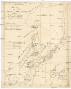
Karte von Jesso und Sagalien
Hokkaidó (Japonsko)
Manchuria
1 : 4000000 Mandžusko (Čína) War Office
Manchuria
1 : 4000000 Mandžusko (Čína) Royal Geographical Society
Ice Chart, Okhotsk Sea Region, May.
U.S. Navy
Ice Chart, Okhotsk Sea Region, July.
U.S. Navy
Mers, Chine, Tartarie. 2.
1 : 6250000 La Perouse, Jean-Francois de Galaup, comte de, 1741-1788
Chart of Discoveries, Made in 1787, in the Seas of China and Tartary, Sheet II.
1 : 6050000 La Perouse, Jean-Francois de Galaup, comte de, 1741-1788
Ice Chart, Okhotsk Sea Region, December.
U.S. Navy
Ice Chart, Okhotsk Sea Region, October.
U.S. Navy
Ice Chart, Okhotsk Sea Region, February.
U.S. Navy
Ice Chart, Okhotsk Sea Region, April
U.S. Navy
Ice Chart, Okhotsk Sea Region, November.
U.S. Navy
Ice Chart, Okhotsk Sea Region, January.
U.S. Navy
Ice Chart, Okhotsk Sea Region, August.
U.S. Navy
Ice Chart, Okhotsk Sea Region, June.
U.S. Navy
Ice Chart, Okhotsk Sea Region, March.
U.S. Navy
Charte von der Nordwestküste Americas nach Vancouver
Vancouver-oblast (Britská Kolumbie) Martius, C. von Schwarzmann, I.
Mandschukuo
1 : 4000000 Mandžusko (Čína) OKH
43-44. Far East, South. The World Atlas.
1 : 3000000 USSR (Union of Soviet Socialist Republics).
[Kaart], uit: Ezo kōkyō yochi zenzu
1 : 1200000 Edo : Harimaya Katsugorō
U.S.S.R. - Far East, Korea, Japan. Pergamon World Atlas.
1 : 5000000 Polish Army Topography Service
Kaart van Japan : behoorende tot de, door het Provinciaal Utrechtsch Genootschap bekroonde Verhandeling van R.G. Bennet en J. van Wyk Rz.
1 : 4500000 R. van Wyk Jz. del. Te Dordrecht : by J. de Vos & Co.
Kaart van Japan / [getekend door] R. van Wijk
Dordrecht : J. de Vos
Japan, 36
1 : 4700000 Appleton, D. & Co.
Map of the Japan Islands
1 : 7000000 Maury, William L J. Ackerman
Chart of the Discoveries to the North of Japan, in 1643.
La Perouse, Jean-Francois de Galaup, comte de, 1741-1788
TATARIAE SINENSIS MAPPA GEOGRAPHICA
1 : 5300000 Dálný východ (Rusko) Mayer, Tobias Anville, Jean-Baptiste Bourguinon d' curis Homannianorum Heredum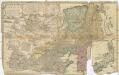
Tatariae Sinensis mappa geographica
1 : 5300000 Dálný východ (Rusko) Mayer, Tobias Anville, Jean-Baptiste Bourguinon d' curis Homannianorum Heredum
Japan. Coal Resources of the World.
1 : 5000000 McInnes, William; Leach, W.W.; Dowling, D.B.