Maps of Litomyšl

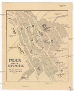
Plán města Litomyšle
Litomyšl (Česko) J.R. Veselík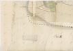
Mapa pozemků litomyšlského vrchnostenského dvora III
1 : 2880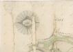
Mapa pozemků litomyšlského vrchnostenského dvora I
1 : 2880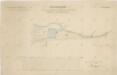
Mapa části panského pozemku u vrchnostenského dvora Pernštejn v Nedošíně
1 : 2918
Leitomischl (Litomissle) - c4172-1-004 - Kaiserpflichtexemplar der Landkarten des stabilen Katasters
1 : 2880
Leitomischl (Litomissle) - c4172-1-001 - Kaiserpflichtexemplar der Landkarten des stabilen Katasters
1 : 2880
Leitomischl (Litomissle) - c4172-1-006 - Kaiserpflichtexemplar der Landkarten des stabilen Katasters
1 : 2880
Leitomischl (Litomissle) - c4172-1-005 - Kaiserpflichtexemplar der Landkarten des stabilen Katasters
1 : 2880
Leitomischl (Litomissle) - c4172-1-003 - Kaiserpflichtexemplar der Landkarten des stabilen Katasters
1 : 2880
Leitomischl (Litomissle) - c4172-1-002 - Kaiserpflichtexemplar der Landkarten des stabilen Katasters
1 : 2880
Indikační skica mapy stabilního katastru pro obec Lány (předměstí města Litomyšle)
1 : 2880
Zahrad (Zahradj) - c9066-1-002 - Kaiserpflichtexemplar der Landkarten des stabilen Katasters
1 : 2880
Zahrad (Zahradj) - c9066-1-001 - Kaiserpflichtexemplar der Landkarten des stabilen Katasters
1 : 2880
Vorstadt Lany (Lany) - c3800-1-001 - Kaiserpflichtexemplar der Landkarten des stabilen Katasters
1 : 2880
Vorstadt Lany (Lany) - c3800-1-002 - Kaiserpflichtexemplar der Landkarten des stabilen Katasters
1 : 2880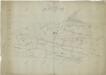
Příruční náčrt mapy pozemků litomyšlského vrchnostenského dvora
1 : 3000
Katastrální mapa obce Nedošín 5
1 : 2880
Mapa velkostatku Litomyšl
1 : 14500


III. vojenské mapování 4056/4
1 : 25000
Hejtmanství Lytomyšlské

Vys. Mýto
1 : 75000 Vysoké Mýto (Česko : oblast) Vojenský zeměpisný ústav
Hohenmauth und Leitomischl
1 : 75000 Litomyšl (Česko : oblast) Storch K. u. k. Militärgeographisches Institut
III. vojenské mapování 4056
1 : 75000
Svitava a okolí
1 : 75000 Svitavy (Česko : oblast) Vojenský zeměpisný ústav
Vys[oké] Mýto a Litomyšl
1 : 75000 Litomyšl (Česko) Vojenský zeměpisný ústav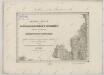
II. vojenské mapování 3
1 : 144000
[Vilímkovy místopisné mapy zemí Koruny české]
1 : 100000 Litomyšl (Česko : oblast) Srp, Jan Jos. R. Vilímek