Maps of Czech Republic

Evanjelická cirkev [sic] česká
Čechy (Česko) Gräf, K. Müller, A.
Die Fahrposten in Prag
Praha (Česko)
Mapa Království českého v 10 listech a v měřítku 1:200,000
1 : 200000 Čechy (Česko)
Neueste general Post & Strassen Karte des Königreichs Boehmen
1 : 590000 Česko Schönfelder von Feuersfeld, Franz Berra, Marco Marco Berra
Neueste general Post & Strassen Karte des Königreichs Boehmen
1 : 575000 Česko Schönfelder z Feuersfeldu, František Berra, Marco Marco Berra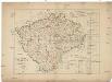
Das Kronland Böhmen
Čechy (Česko) Joseph Bermann
Land Böhmen
1 : 1000000 Most (Česko : oblast) Paul Sollors' Nachf.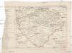
Eisenbahn-Karte von Boehmen
Čechy (Česko) Zdeněk, Jaroslav Šimáček, Josef Franz Řivnáč
Mapa jednot České obce sokolské v září 1889
Čechy (Česko) Podlipný
Mapa jednot České obce sokolské v září 1889
Čechy (Česko) Podlipný
Čechy
Čechy (Česko)
Oro-hydrografische Karte von Böhmen
Čechy (Česko) Jelínek, Karel Langweil, Antonín K. André
Oro-hydrografische Karte von Böhmen
Čechy (Česko) Jelínek, Karel Langweil, Antonín
[Orografická mapa Čech]
Čechy (Česko) bei Eduard Hölzel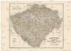
Das chartografische Netz der ombrometrischen Stationen Böhmens
1 : 600000 Čechy (Česko) Purkyně, Emanuel Hickmann, Anton L. böhm. Forstverein
Generální mappa [sic] Království českého
1 : 432000 Česko Kořistka, Karel František Edvard sklad Eduarda Hölzela
Reisekarte des Königreiches Böhmen
1 : 600000 Bílina (Česko : oblast) Wagner, Jan Eduard Mareš, František F. Kytka
Königreich Böhmen
Čechy (Česko) Carl Andre
Geognostische Uibersichts-Karte der Kohlenführenden Formationen von Böhmen
Čechy (Česko) Hennig Verlag der J.G. Calve'schen Buchhandlung
Geognostische Uibersichts-Karte von Böhmen
Čechy (Česko) Hennig Verlag der J.G. Calve'schen Buchhandlung
Národnostní mapa Království českého
Čechy (Česko) Waraus, E. Wagner, Jan Eduard F. Kytka
Gerichts- und Gendarmerie-Karte von Böhmen
1 : 600000 Čechy (Česko) Hoffstätter, L. Artaria u. Comp.
Übersichtskarte zur Landtags-Wahlordnung für das Königreich Boehmen
Čechy (Česko) Brdička, Leopold Leopold Brdiczka
Verwaltungs-Karte des Königreiches Böhmen
Čechy (Česko) Verlag des Landtages
Bez titulu: Soubor reprintů starých map

Králowství České
1 : 1350000 Čechy (Česko) sklad Karla André
Králowství České
Česko Schlieben Ausfeld, Johann Carl sklad Karla André
Geognostisch montanistische Geschäftskarte des Kőnigreich Bőhmen
1 : 750000 Česko Schmidt z Bergenholdu, Jan Ferdinand Mecséry de Tsoor, Karl Freiherr von
Geognostisch montanistische Geschäftskarte des Kőnigreich Bőhmen
1 : 750000 Česko Schmidt z Bergenholdu, Jan Ferdinand Mecséry de Tsoor, Karl Freiherr von
![Evanjelická cirkev [sic] česká](https://images-2.georeferencer.com/images/iiif/921254186617/full/,300/0/native.jpg)

