Maps of okres Opava
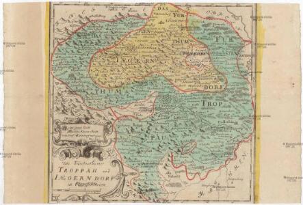
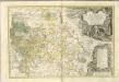
Die Fürstenthümer Troppau und Iaegerndorf in Ober-Schlesien
1 : 420000 Krnov-oblast (Česko) Schleuen, Johann David I.D. Schleuen

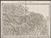
Marchionatus Moraviae Circulus Preroviensis.
1 : 233300 Mollova mapová sbírka Müller, Johann Christoph Homann, Johann Baptista
II. vojenské mapování 5
1 : 144000
Special - Karte der Markgrafschaft Maehren und des Herzogthums Schlesien
Umgebungen von Troppau
1 : 144000 K.K. Militärisches Geographisches Institut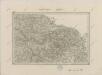
II. vojenské mapování 5
1 : 144000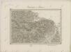
II. vojenské mapování 5
1 : 144000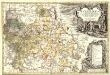
Principatvs Silesiae Karnoviensis nova et exactissima Tabula geographica, commonstrans insimul districtus ac Statvs Minores Frevdenthal Olbersdorf et Stevberndorf.
1 : 1125000 Mollova mapová sbírka Wieland, Johann Wolfgang Homann, Johann Baptista - dědici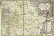
Principatvs Silesiae Karnoviensis nova et exactissima tabula geographica commonstrans insimul districtus ac statvs minores Frevdenthal, Olbersdorf et Stevberndorf
1 : 100000 Bruntál-oblast (Česko) Wieland, Johann Wolfgang Schubarth, Matthäus Homannianos Heredes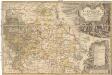
Principatvs Silesiae Karnoviensis nova et exactissima tabula geographica commonstrans insimul districtus ac statvs minores Frevdenthal Olbersdorf et Stevberndorf
1 : 100000 Bruntál-oblast (Česko) Wieland, Johann Wolfgang Schubarth, Matthäus ab Haeredibus Homannianis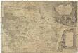
Principatvs Silesiae Karnoviensis nova et exactissima tabula geographica commonstrans insimul districtus ac Statvs minores Frevdenthal, Olbersdorf et Stevberndorf
1 : 100000 Bruntál-oblast (Česko) Wieland, Johann Wolfgang Schubarth, Matthäus Homannianos Heredes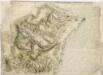
Bez titulu: Plán bitvy u Opavy

Generální mapa okresního hejtmanství Opavského
1 : 250000 Opava-oblast (Česko) Wagner, Jan Eduard F. Kytka
Sprachgrenzlandschaft v. Westschlesien, Hultschin, Kuhland
1 : 150000 Hlučínsko Sobotik, Robert
Troppau
from Spezialkarte der osterreichisch-ungarischen Monarchie.
Freudenthal.
from Spezialkarte der osterreichisch-ungarischen Monarchie.
Podrobná mapa Markrabství moravského a Vévodství slezkého
1 : 100000 Krnov (Česko : oblast) Srp, Jan Jos. R. Vilímek
Karte der Umgebung von Troppau

Podrobná místopisná mapa Království Českého

Podrobná mapa Markrabství moravského a Vévodství slezkého
1 : 100000 Bílovec (Česko : oblast) Srp, Jan Jos. R. Vilímek
III. vojenské mapování 4059
1 : 75000
Zone 6, Col. XVII, Freudenthal, uit: Geologische Karte der im Reichsrathe vertretenen Königreiche und Länder der Österreich-Ungarischen Monarchie : auf Grundlage der Specialkarte i.M. 1:75.000 des k.u.k. Militär-geographischen Institutes / neu bearb. und als Kartenwerk von 341 Blattnummern in zwanglosen Lfg. hrsg. durch die k.k. Geologische Reichsanstalt in Wien
1 : 75000 titelvariant: Geologische Spezialkarte der im Reichsrate vertretenen Königreiche und Länder der Österreichisch-Ungarischen Monarchie; Geologische Specialkarte der im Reichsrathe vertretenen Königreiche und Länder der Österreichisch-Ungarischen Monarchie; Annotatie: Titel bovenaan kaartblad: Geologische Spezialkarte der im Reichsrate vertretenen Königreiche und Länder der Österreichisch-Ungarischen Monarchie en Geologische Specialkarte der im Reichsrathe vertretenen Königreiche und Länder der Österreichisch-Ungarischen Monarchie; Annotatie geografische gegevens: Coördinaten gebaseerd op nulmeridiaan van Ferro (Hierro) Kaiserlich-Königliche Geologische Reichsanstalt, Wenen Wien : K.K. Geologische Reichsanstalt
Opava
1 : 75000 Bílovec (Česko : oblast) Vojenský zeměpisný ústav
Opava
1 : 75000 Bílovec (Česko : oblast) Kartografické odd. při Min. nár. obrany
Troppau
1 : 75000 Morava (Česko) Schuberth K. u. k. Militärgeographisches Institut
Bruntál
1 : 75000 Bruntál (Česko : oblast) Kartografické odd. při Min. nár. obrany
Freudenthal
1 : 75000 Bruntál (Česko : oblast) Charlemont K. u. k. militär-geographisches Institut