Maps of Cork

Insurance Plan of Cork: sheet 11
1 : 480 This detailed 1897 plan of Cork is one of a series of thirteen sheets in an atlas originally produced to aid insurance companies in assessing fire risks. The building footprints, their use (commercial, residential, educational, etc.), the number of floors and the height of the building, as well as construction materials (and thus risk of burning) and special fire hazards (chemicals, kilns, ovens) were documented in order to estimate premiums. Names of individual businesses, property lines, and addresses were also often recorded. Together these maps provide a rich historical shapshot of the commercial activity and urban landscape of towns and cities at the time. The British Library holds a comprehensive collection of fire insurance plans produced by the London-based firm Charles E. Goad Ltd. dating back to 1885. These plans were made for most important towns and cities of the British Isles at the scales of 1:480 (1 inch to 40 feet), as well as many foreign towns at 1:600 (1 inch to 50 feet). Chas E Goad Limited Chas E Goad Limited
Insurance Plan of Cork: sheet 12
1 : 480 This detailed 1896 plan of Cork is one of a series of two sheets in an atlas originally produced to aid insurance companies in assessing fire risks. The building footprints, their use (commercial, residential, educational, etc.), the number of floors and the height of the building, as well as construction materials (and thus risk of burning) and special fire hazards (chemicals, kilns, ovens) were documented in order to estimate premiums. Names of individual businesses, property lines, and addresses were also often recorded. Together these maps provide a rich historical shapshot of the commercial activity and urban landscape of towns and cities at the time. The British Library holds a comprehensive collection of fire insurance plans produced by the London-based firm Charles E. Goad Ltd. dating back to 1885. These plans were made for most important towns and cities of the British Isles at the scales of 1:480 (1 inch to 40 feet), as well as many foreign towns at 1:600 (1 inch to 50 feet). Chas E Goad Limited Chas E Goad Limited
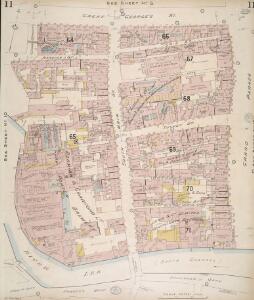
Insurance Plan of Cork: sheet 10
1 : 480 This detailed 1897 plan of Cork is one of a series of thirteen sheets in an atlas originally produced to aid insurance companies in assessing fire risks. The building footprints, their use (commercial, residential, educational, etc.), the number of floors and the height of the building, as well as construction materials (and thus risk of burning) and special fire hazards (chemicals, kilns, ovens) were documented in order to estimate premiums. Names of individual businesses, property lines, and addresses were also often recorded. Together these maps provide a rich historical shapshot of the commercial activity and urban landscape of towns and cities at the time. The British Library holds a comprehensive collection of fire insurance plans produced by the London-based firm Charles E. Goad Ltd. dating back to 1885. These plans were made for most important towns and cities of the British Isles at the scales of 1:480 (1 inch to 40 feet), as well as many foreign towns at 1:600 (1 inch to 50 feet). Chas E Goad Limited Chas E Goad Limited
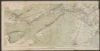
Insurance Plan of Cork: sheet 5-3
1 : 480 This detailed 1897 plan of Cork is one of a series of thirteen sheets in an atlas originally produced to aid insurance companies in assessing fire risks. The building footprints, their use (commercial, residential, educational, etc.), the number of floors and the height of the building, as well as construction materials (and thus risk of burning) and special fire hazards (chemicals, kilns, ovens) were documented in order to estimate premiums. Names of individual businesses, property lines, and addresses were also often recorded. Together these maps provide a rich historical shapshot of the commercial activity and urban landscape of towns and cities at the time. The British Library holds a comprehensive collection of fire insurance plans produced by the London-based firm Charles E. Goad Ltd. dating back to 1885. These plans were made for most important towns and cities of the British Isles at the scales of 1:480 (1 inch to 40 feet), as well as many foreign towns at 1:600 (1 inch to 50 feet). Chas E Goad Limited Chas E Goad Limited
Insurance Plan of Cork: Key Plan
1 : 7200 This "key plan" indicates coverage of the Goad 1897 series of fire insurance maps of Cork that were originally produced to aid insurance companies in assessing fire risks. The building footprints, their use (commercial, residential, educational, etc.), the number of floors and the height of the building, as well as construction materials (and thus risk of burning) and special fire hazards (chemicals, kilns, ovens) were documented in order to estimate premiums. Names of individual businesses, property lines, and addresses were also often recorded. Together these maps provide a rich historical shapshot of the commercial activity and urban landscape of towns and cities at the time. The British Library holds a comprehensive collection of fire insurance plans produced by the London-based firm Charles E. Goad Ltd. dating back to 1885. These plans were made for most important towns and cities of the British Isles at the scales of 1:480 (1 inch to 40 feet), as well as many foreign towns at 1:600 (1 inch to 50 feet). Chas E Goad Limited Chas E Goad Limited
Sheet 16, uit: Ireland
1 : 253440 Annotatie: Voor aanwezige bladen zie overzichtsblad; Alle bladen met aantekeningen in kleurpotlood of inkt; Annotatie geografische gegevens: Maps on the scale of four miles to one inch; Op elk blad een diagram van aangrenzende bladen en een indexdiagram van de corresponderende bladen van de 'one inch map' Dublin : Ordnance Survey of Ireland
Ireland 3.
1 : 760320 Letts, Son & Co.
Nieuwe afteekening van de Zuydkust van Irland van de Blasques tot de Hoek van Waterford int groodt
Ireland Gerard van Keulen
Ireland SE.
1 : 486830 Stanford, Edward
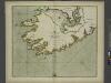
Momonia, hibernice Moun et Woun; anglice Mounster
1 Karte : Kupferdruck ; 40 x 50 cm Blaeu Joan Blaeu
Ireland SW.
1 : 486830 Stanford, Edward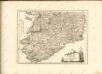
The SOUTH-WEST coast of IRELAND from Dungarvan to the River Shannon
from The sea-atlas : containing an hydrographical description of most of the sea-coasts of the known parts of the world.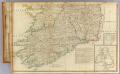
Ireland (south)
1 : 380000 Robert Laurie & James Whittle
Comitatus Lageniae = The countie of Leinster
1 : 1200000 Amstelodami : apud Joannem Janssonium
MOMONIA, | Hibernice | MOUN et WOUN; | Anglice | MOUNSTER
[Amsterdam : Joan Blaeu]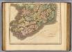
Ireland southern.
1 : 700000 Lizars, Daniel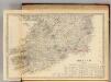
Ireland (south sheet)
1 : 785000 Society for the Diffusion of Useful Knowledge (Great Britain)
Provincia Momoniae. The Province of Mounster. [Karte], in: Gerardi Mercatoris et I. Hondii Newer Atlas, oder, Grosses Weltbuch, Bd. 1, S. 54.
1 Karte aus Atlas Mercator, Gerhard und Hondius, Jodocus Jansson, Jan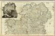
A map of the Kingdom of Ireland (Northern section)
1 : 380000 Rocque, John
Parte del regno d'Irlanda, cioè le provincie di Connaught, e Munster
1 Karte : Kupferdruck ; 40 x 30 cm Zatta presso Antonio Zatta
Provincia Momoniae. The Province of Mounster. [Karte], in: Novus atlas absolutissimus, Bd. 8, S. 192.
1 Karte aus Atlas Janssonius Offizin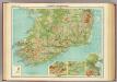
Ireland - southern section.
1 : 633600 John Bartholomew & Co.
Irlandiae Regnum. [Karte], in: Gerardi Mercatoris Atlas, sive, Cosmographicae meditationes de fabrica mundi et fabricati figura, S. 97.
1 Karte aus Atlas Mercator, Gerhard Montanus, Petrus
Provincia Momoniae = The province of Mounster
1 : 690000 Amstelodami : apud Joannem Janssonium
Irlandiae Regnum. [Karte], in: Atlas, sive, Cosmographicae meditationes de fabrica mundi et fabricati figura, S. 98.
1 Karte aus Atlas Mercator, Gerhard
Des Königreichs Ireland Provinz Mounster mit dem sudlichen Theile der Provinzen Leinster und Con[n]aught
1 Karte : Kupferdruck ; 20 x 26 cm Reilly F. J. J. von Reilly
Partie meridio.le du royaume d'Irlande
1 Karte : Kupferdruck ; 38 x 47 cm Sanson; Boazio; Speed; Fortin chez Fortin ing.r mecanicien du roi pour les globes rue de la Harpe pres celle du Foin
Partie meridio.le du royaume d'Irlande
1 Karte : Kupferdruck ; 38 x 47 cm Sanson; Boazio; Speed chez l'autheur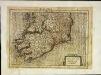
Irlandiæ regnvm
1 Karte : Kupferdruck ; 17 x 24 cm Mercator Cloppenburgh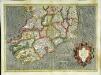
Irlandiae regnvm
1 Karte : Kupferdruck ; 32 x 45 cm Mercator; Hondius Henricus Hondius