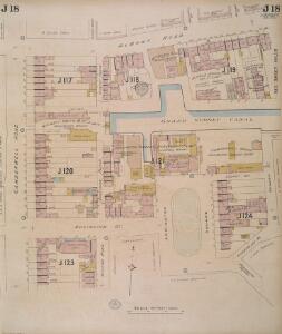
Maps of Lambeth

London South East Vol. J: sheet 18
1 : 480 This detailed 1897 plan of London is one of a series of twenty-seven sheets in an atlas originally produced to aid insurance companies in assessing fire risks. The building footprints, their use (commercial, residential, educational, etc.), the number of floors and the height of the building, as well as construction materials (and thus risk of burning) and special fire hazards (chemicals, kilns, ovens) were documented in order to estimate premiums. Names of individual businesses, property lines, and addresses were also often recorded. Together these maps provide a rich historical shapshot of the commercial activity and urban landscape of towns and cities at the time. The British Library holds a comprehensive collection of fire insurance plans produced by the London-based firm Charles E. Goad Ltd. dating back to 1885. These plans were made for most important towns and cities of the British Isles at the scales of 1:480 (1 inch to 40 feet), as well as many foreign towns at 1:600 (1 inch to 50 feet). Chas E Goad Limited Chas E Goad Limited
Insurance Plan of London South East District Vol. J: sheet 42
1 : 480 This detailed 1903 plan of London is one of a series of nineteen sheets in an atlas originally produced to aid insurance companies in assessing fire risks. The building footprints, their use (commercial, residential, educational, etc.), the number of floors and the height of the building, as well as construction materials (and thus risk of burning) and special fire hazards (chemicals, kilns, ovens) were documented in order to estimate premiums. Names of individual businesses, property lines, and addresses were also often recorded. Together these maps provide a rich historical shapshot of the commercial activity and urban landscape of towns and cities at the time. The British Library holds a comprehensive collection of fire insurance plans produced by the London-based firm Charles E. Goad Ltd. dating back to 1885. These plans were made for most important towns and cities of the British Isles at the scales of 1:480 (1 inch to 40 feet), as well as many foreign towns at 1:600 (1 inch to 50 feet). Chas E Goad Limited Chas E Goad Limited
London XI.25 - OS London Town Plan
1 : 1056 Topographic maps Ordnance Survey Ordnance Survey
Insurance Plan of London South East District Vol. J: sheet 41
1 : 480 This detailed 1903 plan of London is one of a series of nineteen sheets in an atlas originally produced to aid insurance companies in assessing fire risks. The building footprints, their use (commercial, residential, educational, etc.), the number of floors and the height of the building, as well as construction materials (and thus risk of burning) and special fire hazards (chemicals, kilns, ovens) were documented in order to estimate premiums. Names of individual businesses, property lines, and addresses were also often recorded. Together these maps provide a rich historical shapshot of the commercial activity and urban landscape of towns and cities at the time. The British Library holds a comprehensive collection of fire insurance plans produced by the London-based firm Charles E. Goad Ltd. dating back to 1885. These plans were made for most important towns and cities of the British Isles at the scales of 1:480 (1 inch to 40 feet), as well as many foreign towns at 1:600 (1 inch to 50 feet). Chas E Goad Limited Chas E Goad Limited
London South East Vol J: sheet 2
This detailed 1897 plan of London is one of a series of twenty-seven sheets in an atlas originally produced to aid insurance companies in assessing fire risks. The building footprints, their use (commercial, residential, educational, etc.), the number of floors and the height of the building, as well as construction materials (and thus risk of burning) and special fire hazards (chemicals, kilns, ovens) were documented in order to estimate premiums. Names of individual businesses, property lines, and addresses were also often recorded. Together these maps provide a rich historical shapshot of the commercial activity and urban landscape of towns and cities at the time. The British Library holds a comprehensive collection of fire insurance plans produced by the London-based firm Charles E. Goad Ltd. dating back to 1885. These plans were made for most important towns and cities of the British Isles at the scales of 1:480 (1 inch to 40 feet), as well as many foreign towns at 1:600 (1 inch to 50 feet). Chas E Goad Limited Chas E Goad Limited
Surrey III.SW - OS Six-Inch Map
1 : 10560 Topographic maps Ordnance Survey Ordnance Survey
Charles Booth's descriptive map of London poverty 1889
Charles Booth
PLAN SHEWING THE PROPOSED LINE of the LONDON AND GREENWICH RAILWAY
1 : 7200 The title of this plan appears at bottom left, with an explanatory note and scale bar at bottom centre. An illustration of the general construction of the railway features at bottom right. The Greenwich line reached Bermondsey in 1836. A year later, it reached London Bridege, which became the first railway terminus in the capital. Wyld, James
Grundstriss der Statt LONDON wie solche vor und nach dem Brand anzuschen sampt dem Newen Model wie selbige wid rum Auffgebauwet werden solle
This is a map of London immediately after the great fire of 1666. The map was first published by the Merian Heirs of Frankfurt in 1677, appearing in the anthology "Theatri Europei". The title appears in a scroll along the top, flanked by royal and city arms. Notes on shading and an inset plan of Robert Hooke’s designs for rebuilding the city appear in another scroll at the foot of the plate. Hooke's plan is given with its own key and reference table.
PLAN OF WESTMINSTER. No III
The area shaded red represents the extent of Westminster as defined in the Letters Patent of 3 August 1604. Basire, J.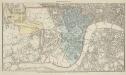
PLAN OF WESTMINSTER. No II
This map is highlighted to give a retrospective view of the extent of Westminster. Represented in blue is the territory of Westminster according to the Decretal of AD1222 , while the red outline shows the present boundary. The green and yellow outlines indicate manor boundaries. Basire, J.
PLAN OF WESTMINSTER. No 1 [A Plan of the City of Westminster, showing all the Parishes, as well as the Ancient Boundary of Westminster, in the year 951.]
An orange coloured area shows the extent of Westminster according to King Edgar's Charter of AD951. The contemporary boundary of Westminster is shown in red. Basire, J.
Insurance Plan of London South West District Vol. K: Key Plan
1 : 10560 This "key plan" indicates coverage of the Goad 1897 series of fire insurance maps of London that were originally produced to aid insurance companies in assessing fire risks. The building footprints, their use (commercial, residential, educational, etc.), the number of floors and the height of the building, as well as construction materials (and thus risk of burning) and special fire hazards (chemicals, kilns, ovens) were documented in order to estimate premiums. Names of individual businesses, property lines, and addresses were also often recorded. Together these maps provide a rich historical shapshot of the commercial activity and urban landscape of towns and cities at the time. The British Library holds a comprehensive collection of fire insurance plans produced by the London-based firm Charles E. Goad Ltd. dating back to 1885. These plans were made for most important towns and cities of the British Isles at the scales of 1:480 (1 inch to 40 feet), as well as many foreign towns at 1:600 (1 inch to 50 feet). Chas E Goad Limited Chas E Goad Limited
London SE.
1 : 15840 Stanford, Edward
The London directory, or a new & improved plan of London, Westminster, & Southwark, with the adjacent country, the new buildings, the new roads, and the late alterations by opening of new streets, & widening of others
1 : 15840
An exact survey of the city's of London Westminster , VII
1 Blatt : 53 x 71 cm John Rocque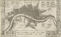
Plan de Londres tel quil Etoit avant l' incendre de 1666 Grave par Hollar
This is a later edition of a 1666map surveyed by Blome and engraved by Hollar. The title appears in French in a panel below the plan, with the key to streets and public buildings appearing in tables at top right, top left and bottom right. A compass star and scale bar are drawn at bottom right. Down both sides of the map are the coats of arms of the 12 Great City Companies (trade guilds), many of which have existed from the middle ages to the present day. Richard Blome was a heraldic writer and cartographer. His maps were often derivative, based on existing sources rather than original surveys. Blome, Richard
London Sheet O - OS Six-Inch Map
1 : 10560 Topographic maps Ordnance Survey Ordnance Survey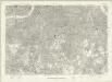
London Sheet O - OS Six-Inch Map
1 : 10560 Topographic maps Ordnance Survey Ordnance Survey
Middlesex XXII - OS Six-Inch Map
1 : 10560 Topographic maps Ordnance Survey Ordnance Survey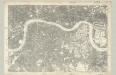
Surrey III - OS Six-Inch Map
1 : 10560 Topographic maps Ordnance Survey Ordnance Survey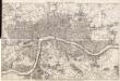
Maps of Old London-J. Rocque
Mitton, Geraldine Edith
The London guide, or, a pocket plan of the cities of London & Westminster & borough of Southwak : with the new buildings &c. to the year 1767
Ellis, J. (John), fl. 1750-1800 Printed for Carington Bowles
LEIGH'S NEW PLAN OF LONDON 213
This map was published in the first edition of 'Leigh's New Picture of London’ in 1818. It shows Southwark Bridge and the proposed New North Road, across Finsbury Fields in Islington. Leigh, Samuel
Londini Angliae regni metropolis delineatio accuratissima / autore F. de Witt
1 : 13000 Wit, Frederik de Amsterdam : F. de Witt
A NEW PLAN OF LONDON, WESTMINSTER AND SOUTHWARK 185
The title of this map appears at top right, with a compass rose and scale bar at bottom right. Below the plan is a list of public offices, with a special section dedicated to those at Somerset House. Designed by William Chambers, Somerset House was built in stages between 1771 and 1835, the first large block ever built to accommodate government offices. Over the years it has housed the Royal Navy, the Stamp Office, Hackney Coaches and Barge Master, the General Register of Births, Deaths and Marriages and the Inland Revenue. Laurie, Robert and Whittle, James
Illustrated map of London, or, Stranger's guide to the public buildings, theatres, music halls, & and all places of interest
Bartlett, G. Warren George H. Young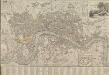
LONDON AND WESTMINSTER 1795
This is the second edition of a map published seven times until 1806. The title is embellished with an engraving of Father Thames, with St Paul's visible in the distance to one side of him. This edition includes an inset plan of the proposed Wet Docks. In 1796, the year this map was published, a Parliamentary Committee attempted to resolve the docking problems such as congestion, delays, lack of warehouse space and theft. The result was a number of project proposals for the building of new docks. However, none of these proposals were carried out, and the problem was not solved until private companies began building enclosed docks in 1802. Fairburn, John
A colored plan, on vellum, of Southwark, and the country on the Surrey side of the Thames from Vauxhall to Deptford, with proposed roads from Westminster Bridge