Maps of Lewisham
Insurance Plan of London East South East District Vol. H: sheet 13-2
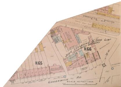
1 : 480 This detailed 1897 plan of London is one of a series of thirteen sheets in an atlas originally produced to aid insurance companies in assessing fire risks. The building footprints, their use (commercial, residential, educational, etc.), the number of floors and the height of the building, as well as construction materials (and thus risk of burning) and special fire hazards (chemicals, kilns, ovens) were documented in order to estimate premiums. Names of individual businesses, property lines, and addresses were also often recorded. Together these maps provide a rich historical shapshot of the commercial activity and urban landscape of towns and cities at the time. The British Library holds a comprehensive collection of fire insurance plans produced by the London-based firm Charles E. Goad Ltd. dating back to 1885. These plans were made for most important towns and cities of the British Isles at the scales of 1:480 (1 inch to 40 feet), as well as many foreign towns at 1:600 (1 inch to 50 feet). Chas E Goad Limited Chas E Goad Limited
London XII.21 - OS London Town Plan
1 : 1056 Topographic maps Ordnance Survey Ordnance Survey
London (1915- Numbered sheets) X.5 (includes: Borough Of Greenwich; Lewisham) - 25 Inch Map
1 : 2500 Topographic maps Ordnance Survey Ordnance Survey
London (Edition of 1894-96) CV (includes: Borough Of Greenwich; Lewisham) - 25 Inch Map
1 : 2500 Topographic maps Ordnance Survey Ordnance Survey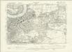
London XII.NW - OS Six-Inch Map
1 : 10560 Topographic maps Ordnance Survey Ordnance Survey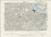
Surrey III.SE - OS Six-Inch Map
1 : 10560 Topographic maps Ordnance Survey Ordnance Survey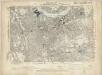
Kent I.SE - OS Six-Inch Map
1 : 10560 Topographic maps Ordnance Survey Ordnance Survey
PLAN SHEWING THE PROPOSED LINE of the LONDON AND GREENWICH RAILWAY
1 : 7200 The title of this plan appears at bottom left, with an explanatory note and scale bar at bottom centre. An illustration of the general construction of the railway features at bottom right. The Greenwich line reached Bermondsey in 1836. A year later, it reached London Bridege, which became the first railway terminus in the capital. Wyld, James
Insurance Plan of London East South East District Vol. H: Key Plan
1 : 10560 This "key plan" indicates coverage of the Goad 1897 series of fire insurance maps of London that were originally produced to aid insurance companies in assessing fire risks. The building footprints, their use (commercial, residential, educational, etc.), the number of floors and the height of the building, as well as construction materials (and thus risk of burning) and special fire hazards (chemicals, kilns, ovens) were documented in order to estimate premiums. Names of individual businesses, property lines, and addresses were also often recorded. Together these maps provide a rich historical shapshot of the commercial activity and urban landscape of towns and cities at the time. The British Library holds a comprehensive collection of fire insurance plans produced by the London-based firm Charles E. Goad Ltd. dating back to 1885. These plans were made for most important towns and cities of the British Isles at the scales of 1:480 (1 inch to 40 feet), as well as many foreign towns at 1:600 (1 inch to 50 feet). Chas E Goad Limited Chas E Goad Limited
FAIRBURN'S PLAN of the proposed WET-DOCKS AND CUT from NEW GRAVEL LANE to BLACKWALL
1 : 16896 The plan's title and publisher's imprint appear at bottom left, with a compass star, key and scale bar at bottom centre.The boundary of the area to be developed is highlighted in red. After a Parliamentary Select Committee in 1796 condemned the congestion at the Port of London, a number of large-scale projects for new docking and shipping facilities were submitted to Parliament. Fairburn's plan illustrates the London merchants' scheme. It consists of an entrance dock that could accommodate 33 loaded ships, two main docks that would accommodate a total of 355 ships and a separate dock for lighters. The plan also included the creation of the 2" 3/4 mile long cut from Wapping to Blackwall. An improved version of this scheme would eventually materialise as the London Docks. Fairburn, John
An exact survey of the city's of London Westminster , II
1 Blatt : 53 x 71 cm John Rocque
London
Grosser Hand-Atlas über alle Theile der Erde in 170 Karten Meyer, J. Verlag des Bibliographischen Instituts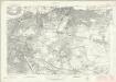
London Sheet P - OS Six-Inch Map
1 : 10560 Topographic maps Ordnance Survey Ordnance Survey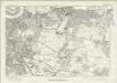
London Sheet P - OS Six-Inch Map
1 : 10560 Topographic maps Ordnance Survey Ordnance Survey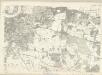
Middlesex XXIII - OS Six-Inch Map
1 : 10560 Topographic maps Ordnance Survey Ordnance Survey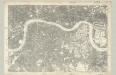
Surrey III - OS Six-Inch Map
1 : 10560 Topographic maps Ordnance Survey Ordnance Survey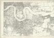
Essex LXXXI - OS Six-Inch Map
1 : 10560 Topographic maps Ordnance Survey Ordnance Survey
A colored plan, on vellum, of Southwark, and the country on the Surrey side of the Thames from Vauxhall to Deptford, with proposed roads from Westminster Bridge

MAP of LONDON and its ENVIRONS 209
This later edition of Sherwood, Neely and Jones's 1813 original. The title appears along the top, with the publisher’s imprint and scale bar below the plan. The map shows Regents Park and the proposed new bridges at Vauxhall and Waterloo, with the Isle of Dogs and the East and West India Docks on an added sheet. Sherwood, Neely & Jones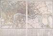
PLAN OF LONDON AND WESTMINSTER with the Borough of SOUTHWARK Being an INDEX to the Large Plan in forty Sheets
This folding map of London was originally published by Faden in 1818 as an index to Harwood's famous map of Regency London. This is a later edition of the map, issued by Wyld when he took over Faden's publishing business. The title, explanation and scale bar feature at top right. The boundaries of London, Westminster, Southwark, Lambeth, Marylebone, Finsbury and Tower Hamlets are outlined in colour. The map is divided into squares with letters and numbers for reference along the margins for reference, with an interpretive key in panel below the plan. Faden, William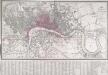
LONDON AND WESTMINSTER with the Borough of SOUTHWARK Being an INDEX to the Large Plan in forty sheets 231
The title, explanatory notesand scale bar of this folding mapappear at top right. The map is divided into squares, with letters and numbers for referencealong the margins. A key appears in a panel below the plan. Originally published by Faden in 1818 as an index to Harwood's famous map of Regency London,the map was reissued by James Wyld when he took over Faden's publishing business in the late 1820s. Faden, William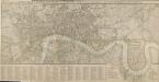
ROWE'S PLAN OF LONDON, WESTMINSTER and SOUTHWARK, exhibiting the various IMPROVEMENTS, to the Year 1804 with the LONDON and WEST INDIA DOCKS
The title of this map appears along the top, with the table of reference in a panel below the plan and scale bar at bottom right. The map is divided into rectangles for reference and shows the newly built London and West India Docks on the Isle of Dogs. Designed by William Jessop, the docks were completed in 1802 allowing West India Company merchants to discharge their ships in four days instead of the usual four weeks. Rowe, Robert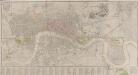
LONDON AND WESTMINSTER
The title of this map appears near the top right in a vignette depicting Father Thames, with compass rose at bottom right, scale bar at bottom centre, and an alphabetical list of streets in the table below the plan. Roads, open spaces and the built-up area within the city are depicted in colour. The boundaries of the 'Liberty’ of the Tower of London is similarly depicted in colour ('Liberty', in this sense, means an area of separate jurisdiction to the rest of the city). Finally, the map extends eastward to include the Isle of Dogs and the docks, which were then under construction. Fairburn, John
LONDON AT ONE VIEW: A NEW MAP
Map of London with title along the top, scale bar at top left and statistical note below the map. Down both sides of the map are views of London prominent buildings and landmarks. Nelson Column, Westminster Hall, Horse Guard, Buckingham Palace and Burlington Arcade are depicted down the left of the map and the Monument, St Paul's Cathedral, Guildhall, the Royal Exchange, Temple Bar and the Thames Tunnel down the right. Biggs, George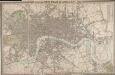
CROSS'S NEW PLAN OF LONDON 1828
The title of this folding map is inset in the top border, with the publisher's imprint and explanatory notes in the bottom border and a list of parishes in a table at top right. The map is divided into half-mile squares for reference, with the river, open spaces and the boundaries of London, Westminster and Southwark highlighted in different colours. Cross, Joseph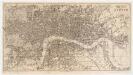
Reynolds's map of London : with the latest improvements
1 : 16000 Martin, Henry, fl. 1830-1852 J. Reynolds
TQ37 - OS 1:25,000 Provisional Series Map
1 : 25000 Topographic maps Ordnance Survey Ordnance Survey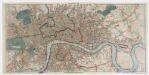
Post office plan of London
Wyld, James, 1812-1887 Ja.s Wyld
Map of London from an Actual Survey
Map of London printed in six sheets from a survey made during the period 1824-26.The map featurestitle and imprint at top right, dedication to King George IV at bottom centre, view of Westminster Abbeywith key to symbols at bottom left and view of St Paul's Cathedral with key to lines at bottom right. Greenwood, Christopher and John