Maps of Hackney

Insurance Plan of London North East District Vol. F: sheet 11
1 : 960 This detailed 1893 plan of London is one of a series of nineteen sheets in an atlas originally produced to aid insurance companies in assessing fire risks. The building footprints, their use (commercial, residential, educational, etc.), the number of floors and the height of the building, as well as construction materials (and thus risk of burning) and special fire hazards (chemicals, kilns, ovens) were documented in order to estimate premiums. Names of individual businesses, property lines, and addresses were also often recorded. Together these maps provide a rich historical shapshot of the commercial activity and urban landscape of towns and cities at the time. The British Library holds a comprehensive collection of fire insurance plans produced by the London-based firm Charles E. Goad Ltd. dating back to 1885. These plans were made for most important towns and cities of the British Isles at the scales of 1:480 (1 inch to 40 feet), as well as many foreign towns at 1:600 (1 inch to 50 feet). Chas E Goad Limited Chas E Goad Limited
London VII.30 - OS London Town Plan
1 : 1056 Topographic maps Ordnance Survey Ordnance Survey
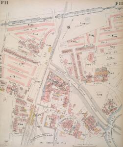
Insurance Plan of London North East District Vol. F: sheet 12
1 : 960 This detailed 1893 plan of London is one of a series of nineteen sheets in an atlas originally produced to aid insurance companies in assessing fire risks. The building footprints, their use (commercial, residential, educational, etc.), the number of floors and the height of the building, as well as construction materials (and thus risk of burning) and special fire hazards (chemicals, kilns, ovens) were documented in order to estimate premiums. Names of individual businesses, property lines, and addresses were also often recorded. Together these maps provide a rich historical shapshot of the commercial activity and urban landscape of towns and cities at the time. The British Library holds a comprehensive collection of fire insurance plans produced by the London-based firm Charles E. Goad Ltd. dating back to 1885. These plans were made for most important towns and cities of the British Isles at the scales of 1:480 (1 inch to 40 feet), as well as many foreign towns at 1:600 (1 inch to 50 feet). Chas E Goad Limited Chas E Goad Limited
Insurance Plan of London North East District Vol. F: sheet 10-2
1 : 960 This detailed 1893 plan of London is one of a series of nineteen sheets in an atlas originally produced to aid insurance companies in assessing fire risks. The building footprints, their use (commercial, residential, educational, etc.), the number of floors and the height of the building, as well as construction materials (and thus risk of burning) and special fire hazards (chemicals, kilns, ovens) were documented in order to estimate premiums. Names of individual businesses, property lines, and addresses were also often recorded. Together these maps provide a rich historical shapshot of the commercial activity and urban landscape of towns and cities at the time. The British Library holds a comprehensive collection of fire insurance plans produced by the London-based firm Charles E. Goad Ltd. dating back to 1885. These plans were made for most important towns and cities of the British Isles at the scales of 1:480 (1 inch to 40 feet), as well as many foreign towns at 1:600 (1 inch to 50 feet). Chas E Goad Limited Chas E Goad Limited
A New & Exact Plan of ye City of LONDON, detail showing Bow
Detail showing Bethnal Green from Bowles' folding map of London of 1731. This is a later edition of the map first issued by Bowles in 1719 extended to include Stepney and the Isle of Dogs. Bowles based this part of the map on Gascoigne's Survey of Stepney of 1703. Gascoigne, J.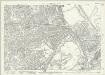
London (1915- Numbered sheets) V.4 (includes: Bethnal Green; Hackney; Poplar Borough) - 25 Inch Map
1 : 2500 Topographic maps Ordnance Survey Ordnance Survey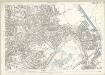
London (Edition of 1894-96) XLI (includes: Bethnal Green; Hackney; Poplar Borough) - 25 Inch Map
1 : 2500 Topographic maps Ordnance Survey Ordnance Survey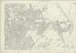
London (First Editions c1850s) XIX (includes: Bethnal Green; Hackney; Poplar Borough) - 25 Inch Map
1 : 2500 Topographic maps Ordnance Survey Ordnance Survey
Insurance Plan of London North East District Vol. F
This "key plan" indicates coverage of the Goad 1893 series of fire insurance maps of London that were originally produced to aid insurance companies in assessing fire risks. The building footprints, their use (commercial, residential, educational, etc.), the number of floors and the height of the building, as well as construction materials (and thus risk of burning) and special fire hazards (chemicals, kilns, ovens) were documented in order to estimate premiums. Names of individual businesses, property lines, and addresses were also often recorded. Together these maps provide a rich historical shapshot of the commercial activity and urban landscape of towns and cities at the time. The British Library holds a comprehensive collection of fire insurance plans produced by the London-based firm Charles E. Goad Ltd. dating back to 1885. These plans were made for most important towns and cities of the British Isles at the scales of 1:480 (1 inch to 40 feet), as well as many foreign towns at 1:600 (1 inch to 50 feet). Chas E Goad Limited Chas E Goad Limited
Insurance Plan of London North East District Vol. F: sheet 13
1 : 960 This detailed 1893 plan of London is one of a series of nineteen sheets in an atlas originally produced to aid insurance companies in assessing fire risks. The building footprints, their use (commercial, residential, educational, etc.), the number of floors and the height of the building, as well as construction materials (and thus risk of burning) and special fire hazards (chemicals, kilns, ovens) were documented in order to estimate premiums. Names of individual businesses, property lines, and addresses were also often recorded. Together these maps provide a rich historical shapshot of the commercial activity and urban landscape of towns and cities at the time. The British Library holds a comprehensive collection of fire insurance plans produced by the London-based firm Charles E. Goad Ltd. dating back to 1885. These plans were made for most important towns and cities of the British Isles at the scales of 1:480 (1 inch to 40 feet), as well as many foreign towns at 1:600 (1 inch to 50 feet). Chas E Goad Limited Chas E Goad Limited
London VIII.21 - OS London Town Plan
1 : 1056 Topographic maps Ordnance Survey Ordnance Survey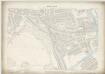
London VII.20 - OS London Town Plan
1 : 1056 Topographic maps Ordnance Survey Ordnance Survey
Insurance Plan of London North East District Vol. F: sheet 9
1 : 960 This detailed 1893 plan of London is one of a series of nineteen sheets in an atlas originally produced to aid insurance companies in assessing fire risks. The building footprints, their use (commercial, residential, educational, etc.), the number of floors and the height of the building, as well as construction materials (and thus risk of burning) and special fire hazards (chemicals, kilns, ovens) were documented in order to estimate premiums. Names of individual businesses, property lines, and addresses were also often recorded. Together these maps provide a rich historical shapshot of the commercial activity and urban landscape of towns and cities at the time. The British Library holds a comprehensive collection of fire insurance plans produced by the London-based firm Charles E. Goad Ltd. dating back to 1885. These plans were made for most important towns and cities of the British Isles at the scales of 1:480 (1 inch to 40 feet), as well as many foreign towns at 1:600 (1 inch to 50 feet). Chas E Goad Limited Chas E Goad Limited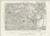
Essex LXXIII.SW - OS Six-Inch Map
1 : 10560 Topographic maps Ordnance Survey Ordnance Survey
Handy Reference Atlas of London
Edinburgh : John Bartholomew & Co.,
Zielgebeit II London
Der Oberbefehlshaber der Luftwaffe, Führungsstab IC
An Actuall Survey of the Parish of St Dunstan Stepney alias Stebunheath ... Taken ... 1703 by Ioel Gascoyne, engraven by Iohn Harris. A scale of 1320 yards[ = 9 inches]

An exact survey of the city's of London Westminster , IV
1 Blatt : 53 x 71 cm John Rocque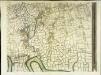
An exact survey of the city's of London Westminster , III
1 Blatt : 53 x 71 cm John Rocque
London
Grosser Hand-Atlas über alle Theile der Erde in 170 Karten Meyer, J. Verlag des Bibliographischen Instituts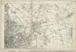
Essex LXXIII - OS Six-Inch Map
1 : 10560 Topographic maps Ordnance Survey Ordnance Survey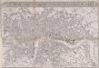
IMPROVED MAP OF LONDON for 1834, from AN ACTUAL SURVEY
The title of this map appears in a panel above the plan, with a scale bar inset in the bottom border. The map extends westward to include Chelsea Beach and shows the proposed tunnel under the Thames at Wapping. The Greenwich-to-London railway line also features. Under construction at the time of this survey, the line reached Bermondsey from Greenwich in 1836. Ten months later the line reached London Bridge, making it the first railway terminus in the capital.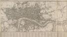
PLAN of the CITIES OF LONDON and WESTMINSTER, with the BOROUGH OF SOUTHWARK, exhibiting all the NEW BUILDINGS to the present YEAR MDCCCVI
As the 19th Century progressed, maps were often used as illustrations for general guides to London, for which there was a great demand. This map appeared in Lambert's 'History of London' of 1806. The title appears along the top with the reference table in a panel below the map. The plan extends eastward to include the East India Docks, opened in 1806. Lambert, B.
LONDINUM, LONDON
This small map possibly derives from a German work published in Nuremberg.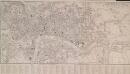
A NEW MAP OF LONDON with the adjacent Villages Including the New Streets and Public Buildings CORRECTED TO 1832
This map of London has an added sheet extending eastward to include the docks in the Isle of Dogs. The map is divided into rectangles, with letters and numbers along the borders for reference. The key to streets, public buildings and prominent places appears in a panel below the plan.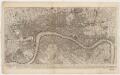
To Martin Folkes esq.r, president of the Royal Society : this plan of the cities of London and Westminster and borough of Southwark, with the contiguous buildings is humbly inscribed
1 : 15000 Rocque, John, d. 1762 John Pine ; John Tinney, print and map sellar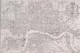
PAYNE'S IMPROVED PLAN OF LONDON
The title of this map appears at top right alongside the publisher’s imprint (in shield) and the city arms. The map is divided in half-mile squares with letters and numbers for reference running along the borders. It shows the Dover, Croydon, Greenwich, Blackwall, Eastern, North London, Great Northern and Birmingham railway lines and their termini. Payne, Albert Henry
Plan showing the sewers in Tower Hamlets, 1843
From 1807, the East End was supplied with water pumped from the River Lea at Bow by the East London Waterworks Company. This was not, however, the continuous flow of water we take for granted today. Dr John Simon wrote, in 1849, of the thousands who "wholly depend on their power of attending at some fixed hour of the day, pail in hand, beside the nearest standcock; where, with their neighbours, they wait their turn; sometimes not without a struggle, during the tedious dribbling of a single small pipe. Household rubbish was piled into heaps in the street and outdoor toilets drained into cesspits. The survey of sanitation in Bethnal Green made by Hector Gavin in 1848 paints a sorry picture. Knightly Court was typical of the streets he visited: "In it there are two privies in a beastly state, full, and the contents overflowing into the court. There is one dust reservoir. One stand-tap supplies the seven houses; two cases of severe typhus lately occurred here, one died." This map of 1843 shows the distribution of sewers through the East End. They carried only surface water, contaminated with decayed rubbish from the streets and excrement from overflowing cesspits, and discharged it directly into the Thames - from which water companies pumped their drinking water. James Beek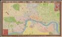
Bauerkeller's new embossed plan of London, 1841
1 : 11500 G. Bauerkeller London [etc.] : Ackermann