Maps of Hackney

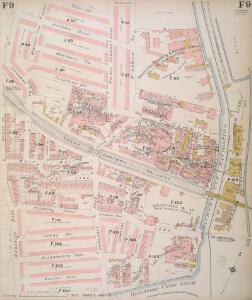
Insurance Plan of London North East District Vol. F: sheet 9
1 : 960 This detailed 1893 plan of London is one of a series of nineteen sheets in an atlas originally produced to aid insurance companies in assessing fire risks. The building footprints, their use (commercial, residential, educational, etc.), the number of floors and the height of the building, as well as construction materials (and thus risk of burning) and special fire hazards (chemicals, kilns, ovens) were documented in order to estimate premiums. Names of individual businesses, property lines, and addresses were also often recorded. Together these maps provide a rich historical shapshot of the commercial activity and urban landscape of towns and cities at the time. The British Library holds a comprehensive collection of fire insurance plans produced by the London-based firm Charles E. Goad Ltd. dating back to 1885. These plans were made for most important towns and cities of the British Isles at the scales of 1:480 (1 inch to 40 feet), as well as many foreign towns at 1:600 (1 inch to 50 feet). Chas E Goad Limited Chas E Goad Limited
London VII.20 - OS London Town Plan
1 : 1056 Topographic maps Ordnance Survey Ordnance Survey
London (1915- Numbered sheets) V.4 (includes: Bethnal Green; Hackney; Poplar Borough) - 25 Inch Map
1 : 2500 Topographic maps Ordnance Survey Ordnance Survey
London (Edition of 1894-96) XLI (includes: Bethnal Green; Hackney; Poplar Borough) - 25 Inch Map
1 : 2500 Topographic maps Ordnance Survey Ordnance Survey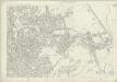
London (First Editions c1850s) XIX (includes: Bethnal Green; Hackney; Poplar Borough) - 25 Inch Map
1 : 2500 Topographic maps Ordnance Survey Ordnance Survey
Insurance Plan of London North East District Vol. F
This "key plan" indicates coverage of the Goad 1893 series of fire insurance maps of London that were originally produced to aid insurance companies in assessing fire risks. The building footprints, their use (commercial, residential, educational, etc.), the number of floors and the height of the building, as well as construction materials (and thus risk of burning) and special fire hazards (chemicals, kilns, ovens) were documented in order to estimate premiums. Names of individual businesses, property lines, and addresses were also often recorded. Together these maps provide a rich historical shapshot of the commercial activity and urban landscape of towns and cities at the time. The British Library holds a comprehensive collection of fire insurance plans produced by the London-based firm Charles E. Goad Ltd. dating back to 1885. These plans were made for most important towns and cities of the British Isles at the scales of 1:480 (1 inch to 40 feet), as well as many foreign towns at 1:600 (1 inch to 50 feet). Chas E Goad Limited Chas E Goad Limited
London VII.10 - OS London Town Plan
1 : 1056 Topographic maps Ordnance Survey Ordnance Survey
London VIII.11 - OS London Town Plan
1 : 1056 Topographic maps Ordnance Survey Ordnance Survey
Insurance Plan of London North East District Vol. F: sheet 11
1 : 960 This detailed 1893 plan of London is one of a series of nineteen sheets in an atlas originally produced to aid insurance companies in assessing fire risks. The building footprints, their use (commercial, residential, educational, etc.), the number of floors and the height of the building, as well as construction materials (and thus risk of burning) and special fire hazards (chemicals, kilns, ovens) were documented in order to estimate premiums. Names of individual businesses, property lines, and addresses were also often recorded. Together these maps provide a rich historical shapshot of the commercial activity and urban landscape of towns and cities at the time. The British Library holds a comprehensive collection of fire insurance plans produced by the London-based firm Charles E. Goad Ltd. dating back to 1885. These plans were made for most important towns and cities of the British Isles at the scales of 1:480 (1 inch to 40 feet), as well as many foreign towns at 1:600 (1 inch to 50 feet). Chas E Goad Limited Chas E Goad Limited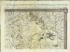
An exact survey of the city's of London Westminster , IV
1 Blatt : 53 x 71 cm John Rocque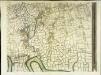
An exact survey of the city's of London Westminster , III
1 Blatt : 53 x 71 cm John Rocque
London
Grosser Hand-Atlas über alle Theile der Erde in 170 Karten Meyer, J. Verlag des Bibliographischen Instituts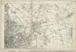
Essex LXXIII - OS Six-Inch Map
1 : 10560 Topographic maps Ordnance Survey Ordnance Survey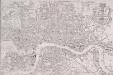
PAYNE'S IMPROVED PLAN OF LONDON
The title of this map appears at top right alongside the publisher’s imprint (in shield) and the city arms. The map is divided in half-mile squares with letters and numbers for reference running along the borders. It shows the Dover, Croydon, Greenwich, Blackwall, Eastern, North London, Great Northern and Birmingham railway lines and their termini. Payne, Albert Henry
Plan showing the sewers in Tower Hamlets, 1843
From 1807, the East End was supplied with water pumped from the River Lea at Bow by the East London Waterworks Company. This was not, however, the continuous flow of water we take for granted today. Dr John Simon wrote, in 1849, of the thousands who "wholly depend on their power of attending at some fixed hour of the day, pail in hand, beside the nearest standcock; where, with their neighbours, they wait their turn; sometimes not without a struggle, during the tedious dribbling of a single small pipe. Household rubbish was piled into heaps in the street and outdoor toilets drained into cesspits. The survey of sanitation in Bethnal Green made by Hector Gavin in 1848 paints a sorry picture. Knightly Court was typical of the streets he visited: "In it there are two privies in a beastly state, full, and the contents overflowing into the court. There is one dust reservoir. One stand-tap supplies the seven houses; two cases of severe typhus lately occurred here, one died." This map of 1843 shows the distribution of sewers through the East End. They carried only surface water, contaminated with decayed rubbish from the streets and excrement from overflowing cesspits, and discharged it directly into the Thames - from which water companies pumped their drinking water. James Beek
LONDON AT ONE VIEW: A NEW MAP
Map of London with title along the top, scale bar at top left and statistical note below the map. Down both sides of the map are views of London prominent buildings and landmarks. Nelson Column, Westminster Hall, Horse Guard, Buckingham Palace and Burlington Arcade are depicted down the left of the map and the Monument, St Paul's Cathedral, Guildhall, the Royal Exchange, Temple Bar and the Thames Tunnel down the right. Biggs, George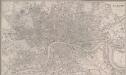
LONDON 270
This map of Victorian London was published in the 'Weekly Dispatch' newspaper of 1756. Its title appears at top right, along with the publisher’s imprint and scale bar. Based on Davies's map of 1847, the map shows London railway termini, the South Western, West London and North Kent lines, and all post-receiving houses and pillars. Cassell, Petter & Calpin
THE RAILWAY BELL AND THE ILLUSTRATED LONDON ADVERTISER MAP OF LONDON
This is a special edition of Biggs's map of London of 1842 for subscriber to the Illustrated London Advertiser. The map features title at the top superimposed to a view of the Thames at St Paul's and views of public buildings down both sides and along the bottom of the plan, with portraits of Queen Victoria and Prince Albert at bottom centre. Biggs, George
London.
1 : 19500 Society for the Diffusion of Useful Knowledge (Great Britain)
London 257
This untitled map of London features scale bar at top left. The city boundary is marked in red, with open land, such as parks and gardens, in green, and the Thames, docks and canals in blue. The map clearly labels the contemporary development of the railway lines, with the Birmingham railway shown intersecting the Regent's Canal at Camden Town. The canal, enthusiastically promoted by architect John Nash, was built to facilitate the import of goods from the provinces. Constructed at the beginning of the era of sustained railway development, however, it never fulfilled its potential and became obsolete.
TQ38 - OS 1:25,000 Provisional Series Map
1 : 25000 Topographic maps Ordnance Survey Ordnance Survey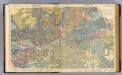
London.
1 : 19495 Letts, Son & Co.
LONDON 269
This map of Victorian London was produced for publication in the Post Office Directory of 1852. The map's title and imprint appear at top right. It shows the entire London railway system. With the exception of Blackfriars and Marylebone stations, all London termini were built in the between 1736and 1876. As the railway companies scrambled to buy land to redevelop central London, many people, mainly slum-dwellers, were left homeless or forced to move to outer suburbs like Tottenham and Edmonton. Davies, Benjamin Rees
LONDON 1849 DRAWN & ENGRAVED EXPRESSLY FOR THE POST OFFICE DIRECTORY
This map has been engraved for the Post Office Directory. It is the third edition of a map originally published in 1847. Davis, Benjamin Rees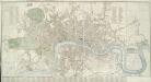
CARY'S New and Accurate Plan of LONDON AND WESTMINSTER, the Borough of SOUTHWARK and parts adjacent 221
The title of this folding map of London runs along the top, with a list of public buildings at top left, facing a list of churches at top right. Open spaces and the city boundaries are drawn in colour, withal reference table in the panel below the plan. John Cary, who first published this map in 1787, added a sheet to this later edition to include the Lea River, the Isle of Dogs and the new docks. The map also shows the Asylum for the Blind in St. George's Fields and the Penitentiary at Millbank. Cary, John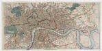
Post office plan of London
Wyld, James, 1812-1887 Ja.s Wyld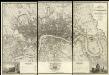
Map of London from an Actual Survey
Map of London printed in six sheets from a survey made during the period 1824-26.The map featurestitle and imprint at top right, dedication to King George IV at bottom centre, view of Westminster Abbeywith key to symbols at bottom left and view of St Paul's Cathedral with key to lines at bottom right. Greenwood, Christopher and John
PLAN of LONDON
Only the main roads appear on this map, giving the appearance of a rather spacious capital city. The new London Bridge is shown without its approaches. Pecked lines show the intended location of the Thames Tunnel. Marc Brunel, father of the great engineer Isobard, solved the problem of how to bore through soft ground or under water, inventing the tunnelling shield. Both father and son worked on the tunnel which was completed as a foot tunnel in 1843, before becoming a railway tunnel for the East London Railway in the 1860s. The East and West India Docks are also shown. Phillips, Horatio
Map of London, shewing the BOUNDARIES of the GENERAL and Two Penny Post
This outline map of London was commissioned by the House of Commons for the21st Report of the Commissioners of Revenue Inquiry in 1830. The map's title features at top right, with the boundaries of the nine postal districts and those of the General-, Two- and Three-Penny Post deliveries outlined in colour. Boundaries are explained at top left with a key to colour usage in panel below the plan. Basire, James