Maps of Wandsworth

Maps of Wandsworth

$title$

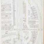
Insurance Plan of London South West District Vol. K: sheet 13

1 : 480 This detailed 1903 plan of London is one of a series of twelve sheets in an atlas originally produced to aid insurance companies in assessing fire risks. The building footprints, their use (commercial, residential, educational, etc.), the number of floors and the height of the building, as well as construction materials (and thus risk of burning) and special fire hazards (chemicals, kilns, ovens) were documented in order to estimate premiums. Names of individual businesses, property lines, and addresses were also often recorded. Together these maps provide a rich historical shapshot of the commercial activity and urban landscape of towns and cities at the time. The British Library holds a comprehensive collection of fire insurance plans produced by the London-based firm Charles E. Goad Ltd. dating back to 1885. These plans were made for most important towns and cities of the British Isles at the scales of 1:480 (1 inch to 40 feet), as well as many foreign towns at 1:600 (1 inch to 50 feet). Chas E Goad Limited Chas E Goad Limited
$title$

London XI.32 - OS London Town Plan

1 : 1056 Topographic maps Ordnance Survey Ordnance Survey
$title$

London (1915- Numbered sheets) IX.5 (includes: Battersea; Lambeth St Mary; Wandsworth Borough) - 25 Inch Map

1 : 2500 Topographic maps Ordnance Survey Ordnance Survey
$title$

London (Edition of 1894-96) CI (includes: Battersea; Lambeth St Mary; Wandsworth Borough) - 25 Inch Map

1 : 2500 Topographic maps Ordnance Survey Ordnance Survey
$title$

London (First Editions c1850s) LXV (includes: Battersea; Lambeth St Mary; Wandsworth Borough) - 25 Inch Map

1 : 2500 Topographic maps Ordnance Survey Ordnance Survey
$title$

London XI.NW - OS Six-Inch Map

1 : 10560 Topographic maps Ordnance Survey Ordnance Survey
$title$

Charles Booth's descriptive map of London poverty 1889

Charles Booth
$title$

Insurance Plan of London South West District Vol. K: Key Plan

1 : 10560 This "key plan" indicates coverage of the Goad 1897 series of fire insurance maps of London that were originally produced to aid insurance companies in assessing fire risks. The building footprints, their use (commercial, residential, educational, etc.), the number of floors and the height of the building, as well as construction materials (and thus risk of burning) and special fire hazards (chemicals, kilns, ovens) were documented in order to estimate premiums. Names of individual businesses, property lines, and addresses were also often recorded. Together these maps provide a rich historical shapshot of the commercial activity and urban landscape of towns and cities at the time. The British Library holds a comprehensive collection of fire insurance plans produced by the London-based firm Charles E. Goad Ltd. dating back to 1885. These plans were made for most important towns and cities of the British Isles at the scales of 1:480 (1 inch to 40 feet), as well as many foreign towns at 1:600 (1 inch to 50 feet). Chas E Goad Limited Chas E Goad Limited
$title$

London SW.

1 : 15840 Stanford, Edward
$title$

Thames and Metropolis Improvement plan

Martin, John
$title$

A PLAN of the ROADS Under the DIRECTION and CARE of this TRUST and divers Roads Adjacent.

1 : 16351 The title of this road map of Kensington and Chelsea appears in a panel above the plan, with the compass star at top right and scale bar at bottom left. The roads within the Kensington and Hyde Park Trust are indicated by a shadowed line; the king's private roads by a double line; the common roads by a double dotted line; and the footpaths by a single dotted line. Turnpikes and junctions are numbered for reference with distances given in a table down the left side of the plate. Roberts, R.
$title$

MAP OF THE WESTERN SIDE OF LONDON, DISTINGUISHING THE ESTATE OF HER MAJESTY'S COMMISSIONERS FOR THE EXHIBITION OF 1851.

1 : 21120 Map of Kensington with title along the top and scale bar below the plan. The site of the Great Exhibiton of 1851 in Hyde Park is highlighted in green. Day & Son
$title$

Insurance Plan of London West & West North West Vols. A & B: Key Plan

1 : 10560 This "key plan" indicates coverage of the Goad 1891 series of fire insurance maps of London that were originally produced to aid insurance companies in assessing fire risks. The building footprints, their use (commercial, residential, educational, etc.), the number of floors and the height of the building, as well as construction materials (and thus risk of burning) and special fire hazards (chemicals, kilns, ovens) were documented in order to estimate premiums. Names of individual businesses, property lines, and addresses were also often recorded. Together these maps provide a rich historical shapshot of the commercial activity and urban landscape of towns and cities at the time. The British Library holds a comprehensive collection of fire insurance plans produced by the London-based firm Charles E. Goad Ltd. dating back to 1885. These plans were made for most important towns and cities of the British Isles at the scales of 1:480 (1 inch to 40 feet), as well as many foreign towns at 1:600 (1 inch to 50 feet). Chas E Goad Limited Chas E Goad Limited
$title$

An exact survey of the city's of London Westminster , VII

1 Blatt : 53 x 71 cm John Rocque
$title$

London Sheet O - OS Six-Inch Map

1 : 10560 Topographic maps Ordnance Survey Ordnance Survey
$title$

London Sheet O - OS Six-Inch Map

1 : 10560 Topographic maps Ordnance Survey Ordnance Survey
$title$

Middlesex XXII - OS Six-Inch Map

1 : 10560 Topographic maps Ordnance Survey Ordnance Survey
$title$

The London guide, or, a pocket plan of the cities of London & Westminster & borough of Southwak : with the new buildings &c. to the year 1767

Ellis, J. (John), fl. 1750-1800 Printed for Carington Bowles
$title$

Insurance Plan of London Western District Vol. A: Key Plan

1 : 21120 This "key plan" indicates coverage of the Goad 1901 series of fire insurance maps of London that were originally produced to aid insurance companies in assessing fire risks. The building footprints, their use (commercial, residential, educational, etc.), the number of floors and the height of the building, as well as construction materials (and thus risk of burning) and special fire hazards (chemicals, kilns, ovens) were documented in order to estimate premiums. Names of individual businesses, property lines, and addresses were also often recorded. Together these maps provide a rich historical shapshot of the commercial activity and urban landscape of towns and cities at the time. The British Library holds a comprehensive collection of fire insurance plans produced by the London-based firm Charles E. Goad Ltd. dating back to 1885. These plans were made for most important towns and cities of the British Isles at the scales of 1:480 (1 inch to 40 feet), as well as many foreign towns at 1:600 (1 inch to 50 feet). Chas E Goad Limited Chas E Goad Limited
$title$

Londini Angliae regni metropolis delineatio accuratissima / autore F. de Witt

1 : 13000 Wit, Frederik de Amsterdam : F. de Witt
$title$

To Martin Folkes esq.r, president of the Royal Society : this plan of the cities of London and Westminster and borough of Southwark, with the contiguous buildings is humbly inscribed

1 : 15000 Rocque, John, d. 1762 John Pine ; John Tinney, print and map sellar
$title$

The stranger's guide to London and Westminster exhibiting all the various alterations and improvements, complete to the present time

Mogg, Edward Edward Mogg
$title$

Map shewing the situation of all premises licensed for the sale of intoxicating liquors in the County of London

London County Council
$title$

LONDON AND WESTMINSTER

The title of this map appears near the top right in a vignette depicting Father Thames, with compass rose at bottom right, scale bar at bottom centre, and an alphabetical list of streets in the table below the plan. Roads, open spaces and the built-up area within the city are depicted in colour. The boundaries of the 'Liberty’ of the Tower of London is similarly depicted in colour ('Liberty', in this sense, means an area of separate jurisdiction to the rest of the city). Finally, the map extends eastward to include the Isle of Dogs and the docks, which were then under construction. Fairburn, John
$title$

CROSS'S NEW PLAN OF LONDON 1828

The title of this folding map is inset in the top border, with the publisher's imprint and explanatory notes in the bottom border and a list of parishes in a table at top right. The map is divided into half-mile squares for reference, with the river, open spaces and the boundaries of London, Westminster and Southwark highlighted in different colours. Cross, Joseph
$title$

BOWLES'S NEW PLAN OF LONDON, WESTMINSTER AND SOUTHWARK, WITH THEIR ENVIRONS TO THE EXTENT OF THREE MILES ROUND ST. PAUL'S

The Bowles family were prolific publishers and their output spans more than a century. This map is relatively unusual as it is presented in a circle. The map is divided by lines into square miles. In the margins of the sheet are reference tables and adverts for coming publications. Baker Street, laid out from 1755 on, is shown by a pecked line, as is Gloucester Street. Carington Bowles
$title$

Reynolds's map of London : with the latest improvements

1 : 16000 Martin, Henry, fl. 1830-1852 J. Reynolds
$title$

TQ27 - OS 1:25,000 Provisional Series Map

1 : 25000 Topographic maps Ordnance Survey Ordnance Survey
$title$

Nouvelle carte du gouvernement civil d'Angleterre et de celuy de la ville de Londres

2 Karten : Kupferdruck ; Bildgrösse 35 x 45 cm Châtelain s.n.
$title$

London.

1 : 19495 Letts, Son & Co.
© MapTiler © OpenStreetMap contributors
How does it work?
These instructions will show you how to find historical maps online.
Getting started
Type the place name in the search box to find the exact location. You can further adjust the search by zooming in and out.
Zoom
Zoom in and out with the buttons or use your mouse or touchpad natively.
Exact Area tool
Click here and draw a rectangle over the map to precisely define the search area.
Set filters
Narrow your search with advanced settings, such as Years (from/to), Fulltext, Publisher, etc.
Results
See the results of your search on the right side. You can scroll down to find more maps of this location.
?

Download OldMapsOnline Mobile