Maps of Islington

Insurance Plan of London Vol. 1: sheet 25
1 : 480 This detailed 1904 plan of London is one of a series of twenty-five sheets in an atlas originally produced to aid insurance companies in assessing fire risks. The building footprints, their use (commercial, residential, educational, etc.), the number of floors and the height of the building, as well as construction materials (and thus risk of burning) and special fire hazards (chemicals, kilns, ovens) were documented in order to estimate premiums. Names of individual businesses, property lines, and addresses were also often recorded. Together these maps provide a rich historical shapshot of the commercial activity and urban landscape of towns and cities at the time. The British Library holds a comprehensive collection of fire insurance plans produced by the London-based firm Charles E. Goad Ltd. dating back to 1885. These plans were made for most important towns and cities of the British Isles at the scales of 1:480 (1 inch to 40 feet), as well as many foreign towns at 1:600 (1 inch to 50 feet). Chas E Goad Limited Chas E Goad Limited
Insurance Plan of City of London Vol. I: sheet 25
1 : 480 This detailed 1886 plan of London is one of a series of twenty-five sheets in an atlas originally produced to aid insurance companies in assessing fire risks. The building footprints, their use (commercial, residential, educational, etc.), the number of floors and the height of the building, as well as construction materials (and thus risk of burning) and special fire hazards (chemicals, kilns, ovens) were documented in order to estimate premiums. Names of individual businesses, property lines, and addresses were also often recorded. Together these maps provide a rich historical shapshot of the commercial activity and urban landscape of towns and cities at the time. The British Library holds a comprehensive collection of fire insurance plans produced by the London-based firm Charles E. Goad Ltd. dating back to 1885. These plans were made for most important towns and cities of the British Isles at the scales of 1:480 (1 inch to 40 feet), as well as many foreign towns at 1:600 (1 inch to 50 feet). Chas E Goad Limited Chas E Goad Limited
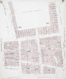
Insurance Plan of London Vol. 1: sheet 23
1 : 480 This detailed 1904 plan of London is one of a series of twenty-five sheets in an atlas originally produced to aid insurance companies in assessing fire risks. The building footprints, their use (commercial, residential, educational, etc.), the number of floors and the height of the building, as well as construction materials (and thus risk of burning) and special fire hazards (chemicals, kilns, ovens) were documented in order to estimate premiums. Names of individual businesses, property lines, and addresses were also often recorded. Together these maps provide a rich historical shapshot of the commercial activity and urban landscape of towns and cities at the time. The British Library holds a comprehensive collection of fire insurance plans produced by the London-based firm Charles E. Goad Ltd. dating back to 1885. These plans were made for most important towns and cities of the British Isles at the scales of 1:480 (1 inch to 40 feet), as well as many foreign towns at 1:600 (1 inch to 50 feet). Chas E Goad Limited Chas E Goad Limited
Insurance Plan of London Vol. 1: sheet 24
1 : 480 This detailed 1904 plan of London is one of a series of twenty-five sheets in an atlas originally produced to aid insurance companies in assessing fire risks. The building footprints, their use (commercial, residential, educational, etc.), the number of floors and the height of the building, as well as construction materials (and thus risk of burning) and special fire hazards (chemicals, kilns, ovens) were documented in order to estimate premiums. Names of individual businesses, property lines, and addresses were also often recorded. Together these maps provide a rich historical shapshot of the commercial activity and urban landscape of towns and cities at the time. The British Library holds a comprehensive collection of fire insurance plans produced by the London-based firm Charles E. Goad Ltd. dating back to 1885. These plans were made for most important towns and cities of the British Isles at the scales of 1:480 (1 inch to 40 feet), as well as many foreign towns at 1:600 (1 inch to 50 feet). Chas E Goad Limited Chas E Goad Limited
Insurance Plan of City of London Vol. I: sheet 23
1 : 480 This detailed 1886 plan of London is one of a series of twenty-five sheets in an atlas originally produced to aid insurance companies in assessing fire risks. The building footprints, their use (commercial, residential, educational, etc.), the number of floors and the height of the building, as well as construction materials (and thus risk of burning) and special fire hazards (chemicals, kilns, ovens) were documented in order to estimate premiums. Names of individual businesses, property lines, and addresses were also often recorded. Together these maps provide a rich historical shapshot of the commercial activity and urban landscape of towns and cities at the time. The British Library holds a comprehensive collection of fire insurance plans produced by the London-based firm Charles E. Goad Ltd. dating back to 1885. These plans were made for most important towns and cities of the British Isles at the scales of 1:480 (1 inch to 40 feet), as well as many foreign towns at 1:600 (1 inch to 50 feet). Chas E Goad Limited Chas E Goad Limited
Insurance Plan of City of London Vol. I: sheet 24
1 : 480 This detailed 1886 plan of London is one of a series of twenty-five sheets in an atlas originally produced to aid insurance companies in assessing fire risks. The building footprints, their use (commercial, residential, educational, etc.), the number of floors and the height of the building, as well as construction materials (and thus risk of burning) and special fire hazards (chemicals, kilns, ovens) were documented in order to estimate premiums. Names of individual businesses, property lines, and addresses were also often recorded. Together these maps provide a rich historical shapshot of the commercial activity and urban landscape of towns and cities at the time. The British Library holds a comprehensive collection of fire insurance plans produced by the London-based firm Charles E. Goad Ltd. dating back to 1885. These plans were made for most important towns and cities of the British Isles at the scales of 1:480 (1 inch to 40 feet), as well as many foreign towns at 1:600 (1 inch to 50 feet). Chas E Goad Limited Chas E Goad Limited
London VII.56 - OS London Town Plan
1 : 1056 Topographic maps Ordnance Survey Ordnance Survey
A Plan of PROPOSED IMPROVEMENTS between THE ROYAL EXCHANGE and FINSBURY SQUARE, In the Wards of Coleman Street & Broad Street In the CITY of LONDON
1 : 7200 This plan shows the intention to remove Bethlem ('Bedlam') Hospital and replace it with the ''London Amphitheatre'' which would comprise at least 60 houses with gardens, stables and coach-houses suitable for ''opulent Citizens''. This complex will be linked directly to the Royal Exchange via a 80-ft wide new street. Luffman, John
CREPLEGATE WARD with its Divisions into Parishes taken from the last Survey with Additions and Corrections 21A
1 : 2880 This plan was published in Strype's first annotated edition of Stow's 'Survey of England'. The title features in cartouche at top left, with scale bar at bottom left, and compass star near bottom right. The keys to streets, yards, halls, courts and private properties are in tables down both sides of the plate, with St Giles church shown pictorially. Blome, Richard
IMPROVEMENTS PROPOSED BY THE HON. CORPORATION OF LONDON BETWEEN THE ROYAL EXCHANGE AND FINSBURY SQUARE
1 : 18000 The principal improvement featured on this plan is the removal of the Bethlem ('Bedlam') hospital and its replacement by the ''London Amphitheatre,'' which would comprise at least 60 houses with gardens, stables and coach-houses suitable for ''opulent Citizens''. This complex would be linked directly to the Royal Exchange via a 80-ft wide new street. Cooke, John
A MAP OF ST. GILES CRIPPLE GATE. WITHOUT. With Large Additions and Corrections 1-A
1 : 1200 Plan of the parish of St. Giles, Cripplegate, in the City of London, published in Strype's first annotated edition of Stow's "Survey of England" of 1720. The plan features title along the top, compass and scale bar at bottom left and key to streets, yards, churches, public buildings etc. in tables at lower left and down the right side of the plan. Blome, Richard
CRIPPLEGATE WARD with its Divisions into PARISHES According to a new SURVEY.
1 : 2742 This plan was published in William Maitland's 'History of London from its Foundation to the Present Time'. The plan's title features in cartouche at bottom right, with the heraldic arms of dedicatee John Blanchford, Alderman of Cripplegate ward, at bottom left. The compass star appears at middle left, with a view of St. Luke's hospital at the top of the plate. Maitland's ward plans were largely derived from Strype's plans, with the illustrations copied from West Tow's 1736 'Prospect Views of Ancient Churches'. Cole, B.
COLEMAN STREET WARD and BASHISHAW WARD Taken from the last Survey with Corrections and Additions. 16
1 : 2088 This map was published in Strype's first annotated edition of Stow's 'Survey of England'. The plan's title features in cartouche at top right, with a compass star at bottom centre, scale bar at bottom right and the keys to streets, yards, halls, courts and private properties in tables to the right of the plan. St. Bartholomew hospital is shown pictorially. Blome, Richard
The WARDS OF COLEMAN STREET AND BASSISHAW Taken from the last Survey WITH Corrections and Amendments.
1 : 2088 This plan was published in William Maitland's 'History of London from its Foundation to the Present Time'. Its title features in cartouche at middle right, with compass star at top left. The suits of arms of the map's dedicatees, ward aldermen Robert Alsop and William Baker, appear at top centre and top right respectively. An illustrated view of St Stephen Coleman's church is included at bottom right. Maitland's ward plans were largely derived from Strype, with the illustrations copied from West & Tow's 1736 'Prospect Views of Ancient Churches'. Cole, B.
Insurance Plan of London Vol. 1: sheet 22
1 : 480 This detailed 1904 plan of London is one of a series of twenty-five sheets in an atlas originally produced to aid insurance companies in assessing fire risks. The building footprints, their use (commercial, residential, educational, etc.), the number of floors and the height of the building, as well as construction materials (and thus risk of burning) and special fire hazards (chemicals, kilns, ovens) were documented in order to estimate premiums. Names of individual businesses, property lines, and addresses were also often recorded. Together these maps provide a rich historical shapshot of the commercial activity and urban landscape of towns and cities at the time. The British Library holds a comprehensive collection of fire insurance plans produced by the London-based firm Charles E. Goad Ltd. dating back to 1885. These plans were made for most important towns and cities of the British Isles at the scales of 1:480 (1 inch to 40 feet), as well as many foreign towns at 1:600 (1 inch to 50 feet). Chas E Goad Limited Chas E Goad Limited
Insurance Plan of City of London Vol. I: sheet 22
1 : 480 This detailed 1886 plan of London is one of a series of twenty-five sheets in an atlas originally produced to aid insurance companies in assessing fire risks. The building footprints, their use (commercial, residential, educational, etc.), the number of floors and the height of the building, as well as construction materials (and thus risk of burning) and special fire hazards (chemicals, kilns, ovens) were documented in order to estimate premiums. Names of individual businesses, property lines, and addresses were also often recorded. Together these maps provide a rich historical shapshot of the commercial activity and urban landscape of towns and cities at the time. The British Library holds a comprehensive collection of fire insurance plans produced by the London-based firm Charles E. Goad Ltd. dating back to 1885. These plans were made for most important towns and cities of the British Isles at the scales of 1:480 (1 inch to 40 feet), as well as many foreign towns at 1:600 (1 inch to 50 feet). Chas E Goad Limited Chas E Goad Limited
Insurance Plan of London Vol. VI: sheet 137-1
1 : 480 This detailed 1887 plan of London is one of a series of twenty-seven sheets in an atlas originally produced to aid insurance companies in assessing fire risks. The building footprints, their use (commercial, residential, educational, etc.), the number of floors and the height of the building, as well as construction materials (and thus risk of burning) and special fire hazards (chemicals, kilns, ovens) were documented in order to estimate premiums. Names of individual businesses, property lines, and addresses were also often recorded. Together these maps provide a rich historical shapshot of the commercial activity and urban landscape of towns and cities at the time. The British Library holds a comprehensive collection of fire insurance plans produced by the London-based firm Charles E. Goad Ltd. dating back to 1885. These plans were made for most important towns and cities of the British Isles at the scales of 1:480 (1 inch to 40 feet), as well as many foreign towns at 1:600 (1 inch to 50 feet). Chas E Goad Limited Chas E Goad Limited
An Actual Survey of the Parish of St. Leonard in Shoreditch, Middlesex, taken in the Year 1745 by Peter Chassereau. 5
Survey of the roads from Old Street Church to Shoreditch Church with both churches shown pictorially, scale bar at lower right, orientation points marked on margins and key to distances between junctions in table at middle left.
Insurance Plan of City of London Vol. I: Key Plan
1 : 480 This "key plan" indicates coverage of the Goad 1886 series of fire insurance maps of London that were originally produced to aid insurance companies in assessing fire risks. The building footprints, their use (commercial, residential, educational, etc.), the number of floors and the height of the building, as well as construction materials (and thus risk of burning) and special fire hazards (chemicals, kilns, ovens) were documented in order to estimate premiums. Names of individual businesses, property lines, and addresses were also often recorded. Together these maps provide a rich historical shapshot of the commercial activity and urban landscape of towns and cities at the time. The British Library holds a comprehensive collection of fire insurance plans produced by the London-based firm Charles E. Goad Ltd. dating back to 1885. These plans were made for most important towns and cities of the British Isles at the scales of 1:480 (1 inch to 40 feet), as well as many foreign towns at 1:600 (1 inch to 50 feet). Chas E Goad Limited Chas E Goad Limited
Plan of the Highways held under the Trustees of the OLD STREET TURNPIKE ROADS in the County of Middlesex
Survey of the streets in the Old Street Turnpike Roads Trust, London, from Goswell Street to Hackney Road with title and scale bar at lower left, compass in the centre and key to distances between junctions in table at bottom right. Wickings, W.
SCHOREDITCH, NORTON FALGATE and CRIPPLEGATE WITHOUT. Taken From y.e last Survey With Corrections 3A
1 : 4800 Plan of Shoreditch in the City of London, published in Strype's first annotated edition of Stow's 'Survey of England'. The plan features title in cartouche at the top of the plate, scale bar and compass at bottom left and key to streets, yards, squares, churches and public buildings in tables at top left and lower right. A dotted line marks the boundary between the parish of St. Leonard Shoreditch and St. Giles Cripple Gate. Hoxton Square, where the development of Shoreditch began in the 1680's is indicated at top right. Blome, Richard
Insurance Plan of London Vol. 1: Key Plan
1 : 3600 This "key plan" indicates coverage of the Goad 1904 series of fire insurance maps of London that were originally produced to aid insurance companies in assessing fire risks. The building footprints, their use (commercial, residential, educational, etc.), the number of floors and the height of the building, as well as construction materials (and thus risk of burning) and special fire hazards (chemicals, kilns, ovens) were documented in order to estimate premiums. Names of individual businesses, property lines, and addresses were also often recorded. Together these maps provide a rich historical shapshot of the commercial activity and urban landscape of towns and cities at the time. The British Library holds a comprehensive collection of fire insurance plans produced by the London-based firm Charles E. Goad Ltd. dating back to 1885. These plans were made for most important towns and cities of the British Isles at the scales of 1:480 (1 inch to 40 feet), as well as many foreign towns at 1:600 (1 inch to 50 feet). Chas E Goad Limited Chas E Goad Limited
London (1915- Numbered sheets) V.11 (includes: Bethnal Green; London; Shoreditch; Stepney) - 25 Inch Map
1 : 2500 Topographic maps Ordnance Survey Ordnance Survey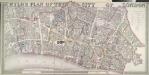
WYLD'S PLAN OF THE CITY OF LONDON
This map of the City of London is based on Horwood's map of 1792-9. The map is enclosed in a border and features title inset in the top border, scale bar and imprint in the bottom border and table with reference to City wards at top right. Ward boundaries are highlighted in colour. Wyld, James
Report of the Improvements and Town Planning Committee to the Right Honourable the Lord Mayor, Aldermen and Commons of the City of London, in Common Council assembled on the preliminary draft proposals for post-war reconstruction in the City of London.
Corporation of London
Greater London Plan 1944. By Patrick Abercrombie
Abercrombie, Patrick His Majesty's Stationery Office
PLAN of the CITY ROAD
1 : 4800 Survey of the City Road, London, from the Angel Inn in Islington to Finsbury Square with title and imprint at top left, compass in the centre, scale bar at bottom right and note on paving of Finsbury Square at lower right. Wickings, W.
PLAN OF THE CITY OF LONDON DIVIDED INTO WARDS
This plan was published in Allen's 'History of London' of 1828. Its title and a list of the city wards feature below the plan, with ward boundaries indicated by a dotted line. City wards were created in the Norman era with aldermen elected for life for the purpose of government. Ward 'beadles' were employed fulltime with responsibility for the "preservation of peace, supervision of trading, sanitation and local upkeep". Allen, Thomas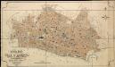
General Plan of the City of London
Haywood, William London