Maps of Westminster

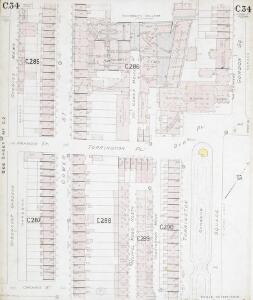
Insurance Plan of London North West District Vol. C: sheet 34
1 : 480 This detailed 1900 plan of London is one of a series of thirteen sheets in an atlas originally produced to aid insurance companies in assessing fire risks. The building footprints, their use (commercial, residential, educational, etc.), the number of floors and the height of the building, as well as construction materials (and thus risk of burning) and special fire hazards (chemicals, kilns, ovens) were documented in order to estimate premiums. Names of individual businesses, property lines, and addresses were also often recorded. Together these maps provide a rich historical shapshot of the commercial activity and urban landscape of towns and cities at the time. The British Library holds a comprehensive collection of fire insurance plans produced by the London-based firm Charles E. Goad Ltd. dating back to 1885. These plans were made for most important towns and cities of the British Isles at the scales of 1:480 (1 inch to 40 feet), as well as many foreign towns at 1:600 (1 inch to 50 feet). Chas E Goad Limited Chas E Goad Limited
Insurance Plan of London North West Vol. C: sheet 2
1 : 480 This detailed 1889 plan of London is one of a series of nine sheets in an atlas originally produced to aid insurance companies in assessing fire risks. The building footprints, their use (commercial, residential, educational, etc.), the number of floors and the height of the building, as well as construction materials (and thus risk of burning) and special fire hazards (chemicals, kilns, ovens) were documented in order to estimate premiums. Names of individual businesses, property lines, and addresses were also often recorded. Together these maps provide a rich historical shapshot of the commercial activity and urban landscape of towns and cities at the time. The British Library holds a comprehensive collection of fire insurance plans produced by the London-based firm Charles E. Goad Ltd. dating back to 1885. These plans were made for most important towns and cities of the British Isles at the scales of 1:480 (1 inch to 40 feet), as well as many foreign towns at 1:600 (1 inch to 50 feet). Chas E Goad Limited Chas E Goad Limited
PLAN Showing INTENDED BUILDINGS between RUSSELL SQUARE and the NEW ROAD
This is a plan of the proposed housing development on the Duke of Bedford's Estate in Bloomsbury, with title and compass at top left, proposed new buildings in pink, and public squares and open spaces in green. With Covent Garden, Bloomsbury was one of the two estates of the Earls and Dukes of Bedford in London. Famous for its squares and terraced houses, developed during the 18th- and early-19th centuries, the estate attracted professional and academic tenants. Hullmandel
A MAP OF THE South Western District OF Saint Pancras Parish
1 : 1800 The title of this plan of St. Pancras Parish appears at lower left with the publisher's imprint and scale bar. Buildings, roads, squares and open spaces are depicted in various colours. A note below the title states that the plan was reduced for the Commissioners of Paving, Lighting, Watching, Watering etc. from a large plan in their possession. Farey, William
Insurance Plan of London North West Vol. C: Key Plan
1 : 480 This "key plan" indicates coverage of the Goad 1889 series of fire insurance maps of London that were originally produced to aid insurance companies in assessing fire risks. The building footprints, their use (commercial, residential, educational, etc.), the number of floors and the height of the building, as well as construction materials (and thus risk of burning) and special fire hazards (chemicals, kilns, ovens) were documented in order to estimate premiums. Names of individual businesses, property lines, and addresses were also often recorded. Together these maps provide a rich historical shapshot of the commercial activity and urban landscape of towns and cities at the time. The British Library holds a comprehensive collection of fire insurance plans produced by the London-based firm Charles E. Goad Ltd. dating back to 1885. These plans were made for most important towns and cities of the British Isles at the scales of 1:480 (1 inch to 40 feet), as well as many foreign towns at 1:600 (1 inch to 50 feet). Chas E Goad Limited Chas E Goad Limited
A plan of the City's Estate in Tottenham Court Road
This plan shows a proposed new street near Bedford Square on land owned by the City of London.In the notes on the left side of the sheet the rationale behind the different colours is explained.Gentlemen's houses are to be built with gardens, at the opposite end of which will be houses for shopkeepers.The shops will have large fronts opening on to Tottenham Court Road.The rear wall of the shop keepers houses are to have no lights or other openings, presumably so as not to overlook the gardens of the gentlemen. Metcalf, R.
A Plan of the intended IMPROVEMENTS, on the Estate of his Grace the Duke of BEDFORD. 1800 16
1 : 2784 The area of Bloomsbury represented in this plan has been part of the metropolitan estate of the Russell family, the Earls and Dukes of Bedford since the 17th century. Many of the names of the streets and squares reflect this connection. The plan shows the old British Museum simply marked ''museum'', Russell Square, Brunswick Square, Tavistock Square, Nursery Ground are all indicated as green spaces. Bloomsbury square is marked by a pecked line and coloured green. Bedford house has become Bedford Place, constructed in 1801-5 by James Burton. Under the 6th Duke of Bedford the area was developed north and east, principally by James Burton and Thomas Cubitt. The resulting squares became a favourite area for writers and painters. Neele
PLAN of CARMARTHEN SQUARE
1 : 1416 Plan of the Carmarthen Estate in Bloomsbury with title at top left, compass at lower right and scale bar at the foot of the plate Whitcomb & Ruthven
London VII.43 - OS London Town Plan
1 : 1056 Topographic maps Ordnance Survey Ordnance Survey
London VII.53 - OS London Town Plan
1 : 1056 Topographic maps Ordnance Survey Ordnance Survey
Insurance Plan of London North West Vol. C: sheet 3
1 : 480 This detailed 1889 plan of London is one of a series of nine sheets in an atlas originally produced to aid insurance companies in assessing fire risks. The building footprints, their use (commercial, residential, educational, etc.), the number of floors and the height of the building, as well as construction materials (and thus risk of burning) and special fire hazards (chemicals, kilns, ovens) were documented in order to estimate premiums. Names of individual businesses, property lines, and addresses were also often recorded. Together these maps provide a rich historical shapshot of the commercial activity and urban landscape of towns and cities at the time. The British Library holds a comprehensive collection of fire insurance plans produced by the London-based firm Charles E. Goad Ltd. dating back to 1885. These plans were made for most important towns and cities of the British Isles at the scales of 1:480 (1 inch to 40 feet), as well as many foreign towns at 1:600 (1 inch to 50 feet). Chas E Goad Limited Chas E Goad Limited
Insurance Plan of London Vol. VIII: sheet 199
1 : 480 This detailed 1888 plan of London is one of a series of twenty-six sheets in an atlas originally produced to aid insurance companies in assessing fire risks. The building footprints, their use (commercial, residential, educational, etc.), the number of floors and the height of the building, as well as construction materials (and thus risk of burning) and special fire hazards (chemicals, kilns, ovens) were documented in order to estimate premiums. Names of individual businesses, property lines, and addresses were also often recorded. Together these maps provide a rich historical shapshot of the commercial activity and urban landscape of towns and cities at the time. The British Library holds a comprehensive collection of fire insurance plans produced by the London-based firm Charles E. Goad Ltd. dating back to 1885. These plans were made for most important towns and cities of the British Isles at the scales of 1:480 (1 inch to 40 feet), as well as many foreign towns at 1:600 (1 inch to 50 feet). Chas E Goad Limited Chas E Goad Limited
To the Most Noble JOHN, DUKE OF BEDFORD. This Plan of the United Parishes of ST. GILES in the FIELDS & ST. GEORGE, BLOOMSBURY, 4
1 : 444 This map is dedicated to the Duke of Bedford as this area was the primary metropolitan estate of the Earls ans Dukes of Bedford. Russell was the family name of the Dukes of Bedford, hence Russell Square. Bedford house, built for the 3rd Earl of Bedford in 1586, lay adjacent to Montague house, later to be the British Museum, until 1705-6 when it was demolished. In the lower left hand corner is a vignette of a statue of a Duke of Bedford. A birds eye view of the British Museum and a view of the College of Surgeons are also included as is a statue of C.J Fox right hon, the orator. Wyld, James
Plan OF THE PARISHES OR DIVISION OF St Giles in the Fields And ST. GEORGE, BLOOMSBURY. 1815 2
1 : 2400 Different pastel colours describe the Parish divisions within St. Giles in the Fields and St. George's, Bloomsbury. A plan of the Burial Ground and Chapel of St. Giles in the Field, adjoining the church yard of St Pancreas, is located in a separate border. Montagu House was sold in 1755 to house the British museum. It was demolished to make way for Smirke''s building in the 1840''s. Hewitt, N.R.
Insurance Plan of London North West District Vol. C: Index Key Plan A
1 : 480 This "key plan" indicates coverage of the Goad 1900 series of fire insurance maps of London that were originally produced to aid insurance companies in assessing fire risks. The building footprints, their use (commercial, residential, educational, etc.), the number of floors and the height of the building, as well as construction materials (and thus risk of burning) and special fire hazards (chemicals, kilns, ovens) were documented in order to estimate premiums. Names of individual businesses, property lines, and addresses were also often recorded. Together these maps provide a rich historical shapshot of the commercial activity and urban landscape of towns and cities at the time. The British Library holds a comprehensive collection of fire insurance plans produced by the London-based firm Charles E. Goad Ltd. dating back to 1885. These plans were made for most important towns and cities of the British Isles at the scales of 1:480 (1 inch to 40 feet), as well as many foreign towns at 1:600 (1 inch to 50 feet). Chas E Goad Limited Chas E Goad Limited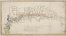
Plan, presented to the House of Commons, of a street proposed from Charing Cross to Portland Place, leading to the Crown Estate in Mary-le-Bone Park.
Basire, James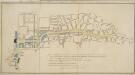
PLAN, presented to the House of Commons, of a STREET proposed from Charing Cross to Portland Place, leading to the Crown Estate in Mary-le-Bone Park
1 : 3684 This original design for Regent Street was commissioned by the House of Commons.The title appears along the top, with a descriptive note below the plan and a scale bar at the bottom centre. Crown Property is highlighted in blue.Starting at Carlton House, Regent Street ran through crownland at Piccadilly (where a circus was built) before turning north-west along Swallow Street, in Soho, finally joining Portland Place north of Oxford Street. Basire, James
Collins' Illustrated Atlas of London with 7000 references, in 36 plates of the principal routes between St. Paul's and the suburbs, from a survey made expressly for this work, by R. Jarman

PLAN OF A Street Proposed FROM CHARING CROSS TO PORTLAND PLACE.
1 : 6000 This is Nash's original design for Regent Street.The title appears at top right, with compass star and scale bar at the bottom left. The course of the street highlighted in yellow, with Crown property is highlighted in blue.Starting at Carlton House, Regent Street ran through crownland at Piccadilly (where a circus was built) before turning north-west along Swallow Street, in Soho, finally joining Portland Place north of Oxford Street. Thompson
Insurance Plan of London: General Key Plan of North Side of River
1 : 4800 This "key plan" indicates coverage of the Goad 1889 series of fire insurance maps of London that were originally produced to aid insurance companies in assessing fire risks. The building footprints, their use (commercial, residential, educational, etc.), the number of floors and the height of the building, as well as construction materials (and thus risk of burning) and special fire hazards (chemicals, kilns, ovens) were documented in order to estimate premiums. Names of individual businesses, property lines, and addresses were also often recorded. Together these maps provide a rich historical shapshot of the commercial activity and urban landscape of towns and cities at the time. The British Library holds a comprehensive collection of fire insurance plans produced by the London-based firm Charles E. Goad Ltd. dating back to 1885. These plans were made for most important towns and cities of the British Isles at the scales of 1:480 (1 inch to 40 feet), as well as many foreign towns at 1:600 (1 inch to 50 feet). Chas E Goad Limited Chas E Goad Limited
Vrbium Londini et West-Monasterii nec non suburbii Southwark accurata ichnographia, 1
1 Blatt : 52 x 64 cm Homännische Erben
A New and Exact Plan of the City of LONDON and Suburbs thereof, With the addition of the New Buildings, Churches &c. to this present Year 1720 (Not extant in any other)
1 : 6336 This map of the West End of London is part of Henry Overton's complete map of London and its suburbs, published in 1720.The title and publisher's imprint appear in cartouche in the centre, with fares of hackney coaches and an overall key at bottom left. The compass rose appears in the river, with parish boundaries outlined in colour. Henry Overton took over his father John's publishing business in 1707 and continued to publish maps from the same address at White Horse near Newgate. Overton, Henry
A new and exact plan of the city of London and suburbs thereof, 1
1 Blatt : 60 x 52 cm Henry Overton
NEW and ACCURATE PLAN of the CITY of WESTMINSTER, The DUTCHY of LANCASTER and Places Adjacent
1 : 11520 The title of this map appears in cartouche at top right, with a compass rose at top left. A territory with its own courts and administration, the Duchy of Lancaster was created in 1267 by Edward III for his younger son John. The Duchy was attached to the Crown when Prince Henry of Bolingbroke, the last Duke of Lancaster, became Henry IV in 1399. To this day, the Duchy has retained its own jurisdiction under the Chancellor of the Duchy of Lancaster.The chancellorship is a high governmental position, and sometimes a cabinet poist. Since, for at least the last two centuries, the Chancellor rarely has had any significant duties pertaining to the Duchy's management, he is usually available as a minister without portfolio. Recent Chancellors have included Labour cabinet minister Mo Mowlam.
A NEW and ACCURATE PLAN of the CITY of WESTMINSTER The DUTCHY of LANCASTER and Places Adjacent
John Rocque developed his surveying talent at a young age, making plans of the great houses and gardens of the nobility.This early experience led to him taking up large-scale surveying, producing plans such as this one of Westminster. Here, Tottenham Court and Marylebone are mostly fields but Westminster has grown sufficiently to demand the construction of a new bridge.Westminster Bridge was opened in 1750 and watermen were paid 163;25,000 in compensation as the new bridge made them largely redundant. The Chelsea Water Works Company, shown south of Totthill Fields, was set up to improve water supply to Westminster and "parts adjacent".The Company were the first to introduce slow sand filtration to purify Thames water. Rocque, John
A New PLAN of the CITY and LIBERTY of WESTMINSTER, Exhibiting all the New Streets & Roads, with the Residences of the Principal Nobility, Public Offices, &c. Not extant in any other Plan.
This map is by Thomas Jeffreys, an exceptional cartographer and publisher whose productions, including maps of North America, are considered to be among the finest of his age. This map shows the new developments in Westminster by use of a colour coding system indicating varying stages of completion. Portman Square (W1), a contemporary development, was begun the year before this map was published. It was built between 1764 and 84 for the landlord Henry William Portman on what was then considered the outskirts of town. Thomas Jeffreys
A Plan of London, Westminst.r and Southwark
This is derivative of Hatton's edition of Braun & Hogenberg's map-view of London. Unusually for a map of its time, most of the buildings are represented in plan instead of pictorially. The Latin text at the foot of the plate in the original are replaced by notes, in English, on the geographic and demographic growth of the city. Braun, Georg & Hogenberg, Frans
Plan of London, West.r and Southwark, w.th y.e Riv.r Thames, as they were survey.d and publisht by Authority toward y.e latter end of y.e reign of Queen Elizaabeth, or about y.e year of our Lord 1600.
This is the fourth edition of Braun &Hogenberg's map view of London. The title in cartouche at the foot of the plate replaces the figures of merchants from the earlier editions. Tudor arms feature at top right, with the city arms at top left and descriptive notes at bottom right and bottom left. Published in Hatton's 'A New View of London; or, an Ample Account of that City', the map is similar in detail to the 'Copperplate Map', the earliest printed map of London of which no complete copy survives. Merchant ships, cranes, mills, bull- and bear-baiting pits, the large tennis courts at Westminster and the stags in St. James’s are examples of London's business and leisure activities. Walled gardens, elegant churches and livery halls testify to the high quality of life enjoyed by its citizens. Braun, Georg & Hogenberg, Frans
Militärgeographische Angaben über England.
Generalstab des Heeres, Abteilung für Kriegskarten u. Vermessungswesen IV. Mil.-Geo