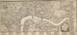
Maps of Westminster

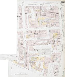
Insurance Plan of London Western District Vol. A: sheet 39-3
1 : 480 This detailed 1901 plan of London is one of a series of forty-one sheets in an atlas originally produced to aid insurance companies in assessing fire risks. The building footprints, their use (commercial, residential, educational, etc.), the number of floors and the height of the building, as well as construction materials (and thus risk of burning) and special fire hazards (chemicals, kilns, ovens) were documented in order to estimate premiums. Names of individual businesses, property lines, and addresses were also often recorded. Together these maps provide a rich historical shapshot of the commercial activity and urban landscape of towns and cities at the time. The British Library holds a comprehensive collection of fire insurance plans produced by the London-based firm Charles E. Goad Ltd. dating back to 1885. These plans were made for most important towns and cities of the British Isles at the scales of 1:480 (1 inch to 40 feet), as well as many foreign towns at 1:600 (1 inch to 50 feet). Chas E Goad Limited Chas E Goad Limited
Insurance Plan of London Western District Vol. A: sheet 39-2
1 : 480 This detailed 1901 plan of London is one of a series of forty-one sheets in an atlas originally produced to aid insurance companies in assessing fire risks. The building footprints, their use (commercial, residential, educational, etc.), the number of floors and the height of the building, as well as construction materials (and thus risk of burning) and special fire hazards (chemicals, kilns, ovens) were documented in order to estimate premiums. Names of individual businesses, property lines, and addresses were also often recorded. Together these maps provide a rich historical shapshot of the commercial activity and urban landscape of towns and cities at the time. The British Library holds a comprehensive collection of fire insurance plans produced by the London-based firm Charles E. Goad Ltd. dating back to 1885. These plans were made for most important towns and cities of the British Isles at the scales of 1:480 (1 inch to 40 feet), as well as many foreign towns at 1:600 (1 inch to 50 feet). Chas E Goad Limited Chas E Goad Limited
Insurance Plan of London Western District Vol. A: sheet 39-1
1 : 480 This detailed 1901 plan of London is one of a series of forty-one sheets in an atlas originally produced to aid insurance companies in assessing fire risks. The building footprints, their use (commercial, residential, educational, etc.), the number of floors and the height of the building, as well as construction materials (and thus risk of burning) and special fire hazards (chemicals, kilns, ovens) were documented in order to estimate premiums. Names of individual businesses, property lines, and addresses were also often recorded. Together these maps provide a rich historical shapshot of the commercial activity and urban landscape of towns and cities at the time. The British Library holds a comprehensive collection of fire insurance plans produced by the London-based firm Charles E. Goad Ltd. dating back to 1885. These plans were made for most important towns and cities of the British Isles at the scales of 1:480 (1 inch to 40 feet), as well as many foreign towns at 1:600 (1 inch to 50 feet). Chas E Goad Limited Chas E Goad Limited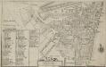
Plan of the Parish of St. Margaret, Westminster From Lea & Morden's Map
1 : 6336 The Abbey, Manchester House and the parish church are shown in elevation. The Decoy in St James' Park is shown. Robert Lea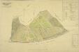
PLAN OF an ESTATE SITUATE AT MILLBANK WESTMINSTER belonging to THE MARQUIS OF SALISBURY.
1 : 1440 South of Tothill Fields lies the estate of The Marquis of Salisbury.The estate had about 30 tenants, each of whom are recorded in a reference list in the top right hand corner.This plan has been copied from an original in the possession of the Commission for Woods and Forests. Land use is indicated by various shades of green and stippling.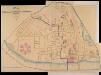
A PLAN of the Streets in the united Parishes of ST. MARGARET & ST. JOHN THE EVANGELIST, Westminster. From a Survey made by I.H. Taylor. No. 22 PARLIAMENT STREET 1828.
Plan of the parishes of St Margaret's, outlined in blue line, and St James', delineated in pink, Westminster. A thin red line shows the boundary of the Tothill Fields District. The large 6-petal structure depicted at lower left is Millbank Penitentiary, built in response to requests for prison reform and finally completed in 1821. Taylor, J. H.
Plan of the Esate belonging to Lord Grosvenor
This plan of Pimlico shows the reservoirs of the Chelsea Water Company, the Ranelagh and Scholars Pond sewers and the proposed new buildings and street layout.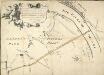
Plan of the Road through Westminster and Tutthill Fields & from St. James's Park Gate by Buckingham House & from Hyde Park Corner to a Bridge that is desired to be made over the Thames 1768 27
This engraved plan shows the road through Tutthill Fields in Westminster leading to the new bridge at Vauxhall.The plan's title features in banner at top left, with compass star at bottom right.The proposed new road stippled and highlighted in colour.
Plan of Lands in the vicinity of the River Thames between Pimlico, Chelsea Hospital and the Penitentiary at Millbank.
1 : 3192 This plan of the parishes of Chelsea and St George, Hanover Square, shows the reservoirs of the Chelsea Water Company and the Ranelagh and Scholars Pond sewers. The note at lower left explains that the drawing is taken from the general plan of the district's sewers made by Peter Potter in 1815. Also shown in the plan are the Ranelagh Gardens, near Chelsea Hospital, which was last licensed as a place of public resort in 1804. Nelson, J.
A New and Exact Plan of the City of LONDON and Suburbs thereof, With the addition of the New Buildings, Churches &c. to this present Year 1720 (Not extant in any other)
1 : 6336 This map of the West End of London is part of Henry Overton's complete map of London and its suburbs, published in 1720.The title and publisher's imprint appear in cartouche in the centre, with fares of hackney coaches and an overall key at bottom left. The compass rose appears in the river, with parish boundaries outlined in colour. Henry Overton took over his father John's publishing business in 1707 and continued to publish maps from the same address at White Horse near Newgate. Overton, Henry
Map SHEWING THE IMPROVEMENTS Now in Progress at the WEST END OF LONDON
1 : 3840 The title of this plan of Hanover Square and the Parish of St George appears with the publisher's imprint at lower right. Compass star and scale bars are featured at top left. The plan shows Buckingham Palace and additions made in the Regency period to the street plan. The Parish of St. George was established in 1725 and extended from Regent Street (then called Swallow Street) to the Serpentine, and from Oxford Street to include the whole of Mayfair, Belgravia and Pimlico. Ward, E. T.
A new and exact plan of the city of London and suburbs thereof, 1
1 Blatt : 60 x 52 cm Henry Overton
NEW and ACCURATE PLAN of the CITY of WESTMINSTER, The DUTCHY of LANCASTER and Places Adjacent
1 : 11520 The title of this map appears in cartouche at top right, with a compass rose at top left. A territory with its own courts and administration, the Duchy of Lancaster was created in 1267 by Edward III for his younger son John. The Duchy was attached to the Crown when Prince Henry of Bolingbroke, the last Duke of Lancaster, became Henry IV in 1399. To this day, the Duchy has retained its own jurisdiction under the Chancellor of the Duchy of Lancaster.The chancellorship is a high governmental position, and sometimes a cabinet poist. Since, for at least the last two centuries, the Chancellor rarely has had any significant duties pertaining to the Duchy's management, he is usually available as a minister without portfolio. Recent Chancellors have included Labour cabinet minister Mo Mowlam.
A NEW and ACCURATE PLAN of the CITY of WESTMINSTER The DUTCHY of LANCASTER and Places Adjacent
John Rocque developed his surveying talent at a young age, making plans of the great houses and gardens of the nobility.This early experience led to him taking up large-scale surveying, producing plans such as this one of Westminster. Here, Tottenham Court and Marylebone are mostly fields but Westminster has grown sufficiently to demand the construction of a new bridge.Westminster Bridge was opened in 1750 and watermen were paid 163;25,000 in compensation as the new bridge made them largely redundant. The Chelsea Water Works Company, shown south of Totthill Fields, was set up to improve water supply to Westminster and "parts adjacent".The Company were the first to introduce slow sand filtration to purify Thames water. Rocque, John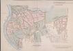
MAP of the GROSVENOR ESTATE (tinted pink) as it was in the Year 1723. with the intended Streets about Grosvenor Square.
1 : 5592 The title of this plan features at top right, with compass star at middle right and explanatory note at bottom right. The boundaries of the St George parish are outlined in red, with the properties in the estate in pink, and parks and open spaces in green. The plan shows the proposed new street plans for Grosvenor Square, but not the Chelsea waterworks,which featured in the original drawing from which this print was produced.
A Plan of London, Westminst.r and Southwark
This is derivative of Hatton's edition of Braun & Hogenberg's map-view of London. Unusually for a map of its time, most of the buildings are represented in plan instead of pictorially. The Latin text at the foot of the plate in the original are replaced by notes, in English, on the geographic and demographic growth of the city. Braun, Georg & Hogenberg, Frans
LONDINUM FERACISSIMI ANGLIAE REGNI METROPOLIS
This derivative of Braun & Hogenberg's 1572 map of London was published in Belle Forest's 'La Cosmographie universelle de tout le monde'. The map's title features at the top of the plate, flanked by Tudor and city arms. Descriptive notes in French appear at bottom left and bottom right, with figures of merchants at bottom centre. The map is similar in detail to the 'Copperplate Map', the earliest printed map of London of which no complete copy survives. Merchant ships, cranes, mills, bull- and bear-baiting pits, the large tennis courts at Westminster and the stags in St. James’s are examples of London business and leisure activities. Walled gardens, elegant churches and livery halls testify to the high quality of life enjoyed by its citizens. Braun, Georg & Hogenberg, Frans
LONDINUM Vulgo LONDON
This later edition of Braun & Hogenberg's map of London and Westminster was published in Janssen's 'Illustrorem Principumque Urbium Septentrionalium Europae'. The map's title appears in a cartouche at the foot of the plate, replacing the figures of merchants of the first edition. Tudor arms feature top right, with city arms at top left and descriptive notes to the bottom right and bottom left. The map is similar in detail to the 'Copperplate Map', the earliest printed map of London of which no complete copy survives. Merchant ships, cranes, mills, bull and bear baiting pits, the large tennis courts at Westminster and the stags in St. James’s are examples of London's business and leisure activities. Walled gardens, elegant churches and livery halls testify to the high quality of life enjoyed by its citizens. Braun, Georg & Hogenberg, Frans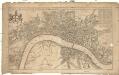
A new mapp of the city of London
1 : 7900 Londýn (Anglie) Overton, Henry John Overton
A POCKET MAP of the Cities of LONDON, WESTMINSTER & SOUTHWARK With the Addition of the Buildings to the Present Year
The title of this pocket map of London, Westminster and Southwark appears in cartouche at bottom centre alongside the city arms. A compass star is depicted in the river with a publisher’s imprint (in scroll) at bottom left. An engraver by trade, Thomas Bowles acquired the stock of cartographers Morden & Lea at the beginning of the 18th Century, starting a successful publishing house, the output of which was almost entirely derivative. Bowles' brother, John, was also a print seller and publisher. Their businesses were separate, but the two often worked together. Bowles, Thomas
A PLAN of HYDE-PARK with the CITY and LIBERTIES of WESTMINSTER &c. Shewing the several IMPROVEMENTS propos'd
This plan shows renovations in Hyde Park and around Westminster.Two Royal palaces have been planned, in Hyde Park and Green Park. The red lines show an intention to regularize the street plan, replacing the narrow irregular streets with a gridlike formation. Gwynn, John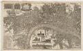
London surveyed, or, a new map of the cities of London and Westminster and the boroguh of Southwark : shewing the several streets and lanes with the most of the alleys & thorough fairs with the additional new buildings to this present year 1742
1 : 5280 Bowles, John, 1701-1779 Printed for John Bowles at the Black Horse in Cornhill
Charles Booth's descriptive map of London poverty 1889
Charles Booth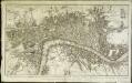
Plan nouveau et correct des villes et fauxbourgs de Londres et Westminster et du bourg de Southwark
1 Plan : Kupferdruck ; 28 x 48 cm Le Rouge Georges Louis le Rouge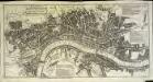
A pocket map of London, Westminster and Southwark
1 Plan : Kupferdruck ; 26 x 51 cm Hoole; Seale printed and sold by H. Overton and J. Hoole at the White Horse without Newgate
PLAN of the CITY'S of LONDON, WESTMINSTER and Borough of SOUTHWARK; with the new Additional Buildings; Anno 1720
This map appeared in "A New General Atlas Containing a Geographical and Historical Account of the World", published by Daniel Browne et al. in 1721. Its title runs along the top, with dedication to Sir Peter Delme, Knight and Alderman, in cartouche at top left. The city arms and insignia, compass rose and scale bar feature at the foot of the plate. Reference tables to places in Westminster, London and Southwark appear in panels below the plan. Parker, S.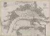
Grundstriss der Statt LONDON wie solche vor und nach dem Brand anzuschen sampt dem Newen Model wie selbige wid rum Auffgebauwet werden solle
This is a map of London immediately after the great fire of 1666. The map was first published by the Merian Heirs of Frankfurt in 1677, appearing in the anthology "Theatri Europei". The title appears in a scroll along the top, flanked by royal and city arms. Notes on shading and an inset plan of Robert Hooke’s designs for rebuilding the city appear in another scroll at the foot of the plate. Hooke's plan is given with its own key and reference table.
PLATTE GRONDT DER STADT LONDON MET NIEUW MODEL EN HOE DIE AFGEBRANDT IS
This later edition of the Frederick de Wit's 1666 plan features minor alterations to the title and some additions on the outskirts of the city. The map's title appears along the top, with the key to parish churches (in scrolls) at top left and top right and dividers at top right. An engraving depicting the city on fire is inset at bottom right. Below the plan, a description of the fire is reported in Dutch and French. This edition of the map shows cherubs holding the reference tables and a waterman with oars leaning against the view of the city. Wit, Frederick de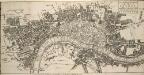
The ICHNOGRAPHY of the Cities of LONDON and WESTMINSTER and the Borough of SOUTHWARK 115x
This small map was published in 'The Natural History of England' by the scientist and instrument-maker Benjamin Martin. It comprised part of the complete 'General Magazine of Arts and Science' issued between 1756 and 1761. The map's title features in a square table at top right, and represents the built-up area within the city boundaries with stippling, and other built-up areas with crosshatching. "Ichnography" means ground-plan. Owen, William