Maps of Westminster

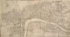
Insurance Plan of London Western District Vol. A: sheet 39-1
1 : 480 This detailed 1901 plan of London is one of a series of forty-one sheets in an atlas originally produced to aid insurance companies in assessing fire risks. The building footprints, their use (commercial, residential, educational, etc.), the number of floors and the height of the building, as well as construction materials (and thus risk of burning) and special fire hazards (chemicals, kilns, ovens) were documented in order to estimate premiums. Names of individual businesses, property lines, and addresses were also often recorded. Together these maps provide a rich historical shapshot of the commercial activity and urban landscape of towns and cities at the time. The British Library holds a comprehensive collection of fire insurance plans produced by the London-based firm Charles E. Goad Ltd. dating back to 1885. These plans were made for most important towns and cities of the British Isles at the scales of 1:480 (1 inch to 40 feet), as well as many foreign towns at 1:600 (1 inch to 50 feet). Chas E Goad Limited Chas E Goad Limited
A MAPP of the Parish of St MARGARETS Westminster taken from the last Survey with Corrections 7 B
This is John Strype's second edition of Stow's survey, published "due to Act of Parliament". This is a reference to the Copyright Act just passed in an effort to stop unauthorised copying of maps. John Stow was a retired sailor who dedicated his retirement to gathering information from records and residents of the Georgian city. The survey extended to include London and Westminster in their entirety, capturing London between Restoration and 18th-century developments. The land on Mill Bank is denoted "Marshy Ground". Renowned for its unhealthy damp atmosphere, it would become the site of the infamous Millbank Penitentiary, and later Tate Britain. Above this a "New Church" sin the process of completion. This would become St John's. Although the survey proved popular, Stow died in poverty at the age of 80,having been granted licence to beg by James I. Stow, John
A MAPP of the Parish of St MARGARETS Westminster taken from the last Survey with Corrections 7A
1 : 3692 This is John Strype's first edition of Stow's survey. John Stow was a retired sailor who dedicated his retirement to gathering information from records and residents of the Georgian city.The survey extended to include London and Westminster in their entirety, capturing London between Restoration and 18th-century developments.The land on Mill Bank is denoted "Marshy Ground". Renowned for its unhealthy damp atmosphere,it would become the site of the infamous Millbank Penitentiary, and later Tate Britain. Above this a "New Church" is in the process of completion. This would become St John's. Although the survey proved popular, Stow died in poverty at the age of 80, having been granted licence to beg by James I. Stow, John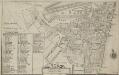
Plan of the Parish of St. Margaret, Westminster From Lea & Morden's Map
1 : 6336 The Abbey, Manchester House and the parish church are shown in elevation. The Decoy in St James' Park is shown. Robert Lea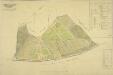
PLAN OF an ESTATE SITUATE AT MILLBANK WESTMINSTER belonging to THE MARQUIS OF SALISBURY.
1 : 1440 South of Tothill Fields lies the estate of The Marquis of Salisbury.The estate had about 30 tenants, each of whom are recorded in a reference list in the top right hand corner.This plan has been copied from an original in the possession of the Commission for Woods and Forests. Land use is indicated by various shades of green and stippling.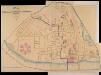
A PLAN of the Streets in the united Parishes of ST. MARGARET & ST. JOHN THE EVANGELIST, Westminster. From a Survey made by I.H. Taylor. No. 22 PARLIAMENT STREET 1828.
Plan of the parishes of St Margaret's, outlined in blue line, and St James', delineated in pink, Westminster. A thin red line shows the boundary of the Tothill Fields District. The large 6-petal structure depicted at lower left is Millbank Penitentiary, built in response to requests for prison reform and finally completed in 1821. Taylor, J. H.
Plan of the Esate belonging to Lord Grosvenor
This plan of Pimlico shows the reservoirs of the Chelsea Water Company, the Ranelagh and Scholars Pond sewers and the proposed new buildings and street layout.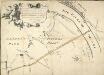
Plan of the Road through Westminster and Tutthill Fields & from St. James's Park Gate by Buckingham House & from Hyde Park Corner to a Bridge that is desired to be made over the Thames 1768 27
This engraved plan shows the road through Tutthill Fields in Westminster leading to the new bridge at Vauxhall.The plan's title features in banner at top left, with compass star at bottom right.The proposed new road stippled and highlighted in colour.
Plan of Lands in the vicinity of the River Thames between Pimlico, Chelsea Hospital and the Penitentiary at Millbank.
1 : 3192 This plan of the parishes of Chelsea and St George, Hanover Square, shows the reservoirs of the Chelsea Water Company and the Ranelagh and Scholars Pond sewers. The note at lower left explains that the drawing is taken from the general plan of the district's sewers made by Peter Potter in 1815. Also shown in the plan are the Ranelagh Gardens, near Chelsea Hospital, which was last licensed as a place of public resort in 1804. Nelson, J.
A New and Exact Plan of the City of LONDON and Suburbs thereof, With the addition of the New Buildings, Churches &c. to this present Year 1720 (Not extant in any other)
1 : 6336 This map of the West End of London is part of Henry Overton's complete map of London and its suburbs, published in 1720.The title and publisher's imprint appear in cartouche in the centre, with fares of hackney coaches and an overall key at bottom left. The compass rose appears in the river, with parish boundaries outlined in colour. Henry Overton took over his father John's publishing business in 1707 and continued to publish maps from the same address at White Horse near Newgate. Overton, Henry
Map SHEWING THE IMPROVEMENTS Now in Progress at the WEST END OF LONDON
1 : 3840 The title of this plan of Hanover Square and the Parish of St George appears with the publisher's imprint at lower right. Compass star and scale bars are featured at top left. The plan shows Buckingham Palace and additions made in the Regency period to the street plan. The Parish of St. George was established in 1725 and extended from Regent Street (then called Swallow Street) to the Serpentine, and from Oxford Street to include the whole of Mayfair, Belgravia and Pimlico. Ward, E. T.
A new and exact plan of the city of London and suburbs thereof, 1
1 Blatt : 60 x 52 cm Henry Overton
NEW and ACCURATE PLAN of the CITY of WESTMINSTER, The DUTCHY of LANCASTER and Places Adjacent
1 : 11520 The title of this map appears in cartouche at top right, with a compass rose at top left. A territory with its own courts and administration, the Duchy of Lancaster was created in 1267 by Edward III for his younger son John. The Duchy was attached to the Crown when Prince Henry of Bolingbroke, the last Duke of Lancaster, became Henry IV in 1399. To this day, the Duchy has retained its own jurisdiction under the Chancellor of the Duchy of Lancaster.The chancellorship is a high governmental position, and sometimes a cabinet poist. Since, for at least the last two centuries, the Chancellor rarely has had any significant duties pertaining to the Duchy's management, he is usually available as a minister without portfolio. Recent Chancellors have included Labour cabinet minister Mo Mowlam.
A NEW and ACCURATE PLAN of the CITY of WESTMINSTER The DUTCHY of LANCASTER and Places Adjacent
John Rocque developed his surveying talent at a young age, making plans of the great houses and gardens of the nobility.This early experience led to him taking up large-scale surveying, producing plans such as this one of Westminster. Here, Tottenham Court and Marylebone are mostly fields but Westminster has grown sufficiently to demand the construction of a new bridge.Westminster Bridge was opened in 1750 and watermen were paid 163;25,000 in compensation as the new bridge made them largely redundant. The Chelsea Water Works Company, shown south of Totthill Fields, was set up to improve water supply to Westminster and "parts adjacent".The Company were the first to introduce slow sand filtration to purify Thames water. Rocque, John
Ordnance Survey of London Skeleto
Ordnance Survey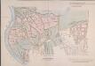
MAP of the GROSVENOR ESTATE (tinted pink) as it was in the Year 1723. with the intended Streets about Grosvenor Square.
1 : 5592 The title of this plan features at top right, with compass star at middle right and explanatory note at bottom right. The boundaries of the St George parish are outlined in red, with the properties in the estate in pink, and parks and open spaces in green. The plan shows the proposed new street plans for Grosvenor Square, but not the Chelsea waterworks,which featured in the original drawing from which this print was produced.
A Plan of London, Westminst.r and Southwark
This is derivative of Hatton's edition of Braun & Hogenberg's map-view of London. Unusually for a map of its time, most of the buildings are represented in plan instead of pictorially. The Latin text at the foot of the plate in the original are replaced by notes, in English, on the geographic and demographic growth of the city. Braun, Georg & Hogenberg, Frans
LONDINUM FERACISSIMI ANGLIAE REGNI METROPOLIS
This derivative of Braun & Hogenberg's 1572 map of London was published in Belle Forest's 'La Cosmographie universelle de tout le monde'. The map's title features at the top of the plate, flanked by Tudor and city arms. Descriptive notes in French appear at bottom left and bottom right, with figures of merchants at bottom centre. The map is similar in detail to the 'Copperplate Map', the earliest printed map of London of which no complete copy survives. Merchant ships, cranes, mills, bull- and bear-baiting pits, the large tennis courts at Westminster and the stags in St. James’s are examples of London business and leisure activities. Walled gardens, elegant churches and livery halls testify to the high quality of life enjoyed by its citizens. Braun, Georg & Hogenberg, Frans
Plan of London, West.r and Southwark, w.th y.e Riv.r Thames, as they were survey.d and publisht by Authority toward y.e latter end of y.e reign of Queen Elizaabeth, or about y.e year of our Lord 1600.
This is the fourth edition of Braun &Hogenberg's map view of London. The title in cartouche at the foot of the plate replaces the figures of merchants from the earlier editions. Tudor arms feature at top right, with the city arms at top left and descriptive notes at bottom right and bottom left. Published in Hatton's 'A New View of London; or, an Ample Account of that City', the map is similar in detail to the 'Copperplate Map', the earliest printed map of London of which no complete copy survives. Merchant ships, cranes, mills, bull- and bear-baiting pits, the large tennis courts at Westminster and the stags in St. James’s are examples of London's business and leisure activities. Walled gardens, elegant churches and livery halls testify to the high quality of life enjoyed by its citizens. Braun, Georg & Hogenberg, Frans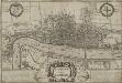
LONDINUM Vulgo LONDON
This later edition of Braun & Hogenberg's map of London and Westminster was published in Janssen's 'Illustrorem Principumque Urbium Septentrionalium Europae'. The map's title appears in a cartouche at the foot of the plate, replacing the figures of merchants of the first edition. Tudor arms feature top right, with city arms at top left and descriptive notes to the bottom right and bottom left. The map is similar in detail to the 'Copperplate Map', the earliest printed map of London of which no complete copy survives. Merchant ships, cranes, mills, bull and bear baiting pits, the large tennis courts at Westminster and the stags in St. James’s are examples of London's business and leisure activities. Walled gardens, elegant churches and livery halls testify to the high quality of life enjoyed by its citizens. Braun, Georg & Hogenberg, Frans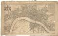
A new mapp of the city of London
1 : 7900 Londýn (Anglie) Overton, Henry John Overton
London, Westminster and Southwark
1 : 10138 This untitled map of Stuart London features royal arms at top left, city arms at top right, with a scale bar and dividers shown beneath a female figure with a globe at lower left. A key to Southwark's churches is provided at lower right. This map is derivative of Wenceslaus Hollar posthumously published plan of 1685 and features vignettes of prominent buildings along the top, together with portraits of King William and Queen Mary. At the foot of the plate, views of the seven city gates and the Tower of London accompany equestrian statues of Charles I and Charles II.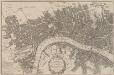
A POCKET MAP of the Cities of LONDON, WESTMINSTER & SOUTHWARK With the Addition of the Buildings to the Present Year
The title of this pocket map of London, Westminster and Southwark appears in cartouche at bottom centre alongside the city arms. A compass star is depicted in the river with a publisher’s imprint (in scroll) at bottom left. An engraver by trade, Thomas Bowles acquired the stock of cartographers Morden & Lea at the beginning of the 18th Century, starting a successful publishing house, the output of which was almost entirely derivative. Bowles' brother, John, was also a print seller and publisher. Their businesses were separate, but the two often worked together. Bowles, Thomas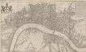
A New Mapp of the CITTY OF LONDON much Inlarged since the great Fire in 1666
This title of this map of Stuart London appears along the top, with the City arms depicted at top left, and a reference panel at top right. A scale bar with dividers features at bottom left, with the key to individual churches in Southwark in a banner at bottom right. Like many other contemporary plans of London, this one is derivative of Hollar's posthumously published map of1685. Overton, John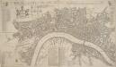
A NEW Mapp of the CITY of LONDON &c. With the Many additional Buildings and New Streets Anno 1720 In a Playne Method for Easy finding any street at first View
This is a later edition of a map first published in 1716. The title appears along the top, with a key to churches at top left, alongside coats of arms representing the City and the twelve Great Livery Companies. The key to individual city wards appears at top right. At bottom left are a compass rose, scale bar and the key to public buildings. Rates of hackney coaches and water ferries appear in a table at bottom centre. The map is similar to Overton’s map of 1706, showing St. Paul's and other prominent buildings pictorially. Taylor, Thomas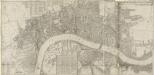
LONDON, WESTMINSTER & SOUTHWARK
This map of London was printed in six sections. The title appears in ribbon at top right, with a compass in the river at lower left, facing a key to company halls in a table at top left. City wards and parishes are shown in a table at bottom centre, with the streets of Westminster in a table at bottom left. Morden, Robert & Lea, Philip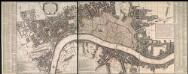
A New and Exact Plan of Ye City of London and suburbs thereof, 1731 93
This is the third edition of Overton's map of London and the suburbs first issued in 1720. The map features title in cartouche at top left, lists of Hackney coaches and watermen's rates at bottom left and centre, City arms at bottom right and compass in river. The area within the boundaries of the City of London is stippled, with ward boundaries highlighted in colour. The map is divided in squares with letters along the margins for reference. Overton, Henry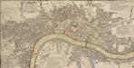
A Pocket MAP of LONDON, WESTMINSTER and SOUTHWARK With the New Buildings to ye Year 1760. Not Extant in any other Map.
The title of this map appears in ornamental cartouche at top left, with fares of hackney coaches in tables at top- and middle-right. Fares of water ferries feature at bottom centre. The built-up area is stippled in the City of London itself, and hatched elsewhere, with the city boundaries outlined in colours. The map is a later edition of the map first issued by George Foster in 1739, updated to include the approaches to Westminster Bridge and the intended new bridge at Blackfriars. Sayer, Robert
A PLAN of HYDE-PARK with the CITY and LIBERTIES of WESTMINSTER &c. Shewing the several IMPROVEMENTS propos'd
This plan shows renovations in Hyde Park and around Westminster.Two Royal palaces have been planned, in Hyde Park and Green Park. The red lines show an intention to regularize the street plan, replacing the narrow irregular streets with a gridlike formation. Gwynn, John