Maps of Westminster

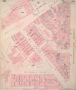
Insurance Plan of London Vol. VIII: sheet 181
1 : 480 This detailed 1888 plan of London is one of a series of twenty-six sheets in an atlas originally produced to aid insurance companies in assessing fire risks. The building footprints, their use (commercial, residential, educational, etc.), the number of floors and the height of the building, as well as construction materials (and thus risk of burning) and special fire hazards (chemicals, kilns, ovens) were documented in order to estimate premiums. Names of individual businesses, property lines, and addresses were also often recorded. Together these maps provide a rich historical shapshot of the commercial activity and urban landscape of towns and cities at the time. The British Library holds a comprehensive collection of fire insurance plans produced by the London-based firm Charles E. Goad Ltd. dating back to 1885. These plans were made for most important towns and cities of the British Isles at the scales of 1:480 (1 inch to 40 feet), as well as many foreign towns at 1:600 (1 inch to 50 feet). Chas E Goad Limited Chas E Goad Limited
Whitehall, showing the Admiralty
1 : 192 Stretching from the edge of St James's Park to Buckingham Court and Spring Garden Mews, this map shows the Admiralty buildings at Whitehall. Ordnance Storehouses are noted along the edge of the park. The drawing features plans of the individual buildings, including details such as staircases, piers and water closets. Chawner, Thomas
Plan of Whitehall Place
1 : 180 Plan showing properties in Whitehall Place. Chawner, Thomas
A reduced copy of FISHER'S GROUND PLAN of the ROYAL PALACE of WHITEHALL, taken in the Reign of CHARLES 2d 1680.
This plan of the Royal Palace was published in the early 19th century, but is actually a copy of a plan dating from 1680. A black star shows where King Charles I was beheaded in the January of 1649, after he was convicted of treason by Parliament. Smith, John Thomas
A drawn Plan of the Palace at Whitehall, taken about 1680

Insurance Plan of London Vol. VIII: sheet 182
1 : 480 This detailed 1888 plan of London is one of a series of twenty-six sheets in an atlas originally produced to aid insurance companies in assessing fire risks. The building footprints, their use (commercial, residential, educational, etc.), the number of floors and the height of the building, as well as construction materials (and thus risk of burning) and special fire hazards (chemicals, kilns, ovens) were documented in order to estimate premiums. Names of individual businesses, property lines, and addresses were also often recorded. Together these maps provide a rich historical shapshot of the commercial activity and urban landscape of towns and cities at the time. The British Library holds a comprehensive collection of fire insurance plans produced by the London-based firm Charles E. Goad Ltd. dating back to 1885. These plans were made for most important towns and cities of the British Isles at the scales of 1:480 (1 inch to 40 feet), as well as many foreign towns at 1:600 (1 inch to 50 feet). Chas E Goad Limited Chas E Goad Limited
Plan of Spring Gardens, with Improvements and Additions.] 1
1 : 456 Plan of the proposed improvements to the Spring gardens in St James's. The gardens were known for the Great Room, used throughout the 18th century as an exhibition room, museum and concert hall. Chawner, Thomas
Schetch for the Situation of a Palace at Whitehall the better to Settle that of a Bridge and of a Road to it
Plan of a proposed new palace at Whitehall with key down the left side of the plate.
The Plan of ye City of Westminster [showing five locations proposed for the placing of a new bridge]
1 : 3600 Due to the growth of the area in the 18th century, a bridge at Westminster became necessary.This plan shows suggested locations for the building of a bridge. The five locations proposed are: "A", the Horse Ferry on Millbank; "B", College Street or the Slaughter House; "C", the wool stable opposite New Place Yard; "D", Stephen's Alley; "E", Whitehall. There are evident concerns about the Whitehall location being too near the 'elbow' of the river. Cole, B.
A MAPP of the Parish of St MARTINS in the FIELDS, taken from ye last survey, with Additions By Blome, Richard.
1 : 3600 This plan of the parish of St Martins in the Fields shows the Banqueting House at Whitehall, the New Exchange on the Strand and Northumberland House.Near the top of the plate, the southern part of today's Leicester Square is indicated with the name of Leicester Fields. The equestrian statue of Charles I is depicted at Charing Cross. A pecked line marks the boundaries with the neighbouring parishes of St James and St Giles. Blome, Richard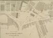
PLAN OF THE CHARING CROSS & STRAND IMPROVEMENTS 1832
Trafalgar Square is indicated in this plan of Charing Cross as King William Square. The National Gallery of Painting and Sculpture is also indicated on the plan. Founded in 1824, the National Gallery was initially housed in a building in Pall Mall until a more suitable one was built on the north side of Trafalgar Square in 1832-38 to a design by William Wilkins. Wyld, James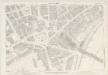
London VII.73 - OS London Town Plan
1 : 1056 Topographic maps Ordnance Survey Ordnance Survey
Insurance Plan of London Vol. VIII: sheet 180
1 : 480 This detailed 1888 plan of London is one of a series of twenty-six sheets in an atlas originally produced to aid insurance companies in assessing fire risks. The building footprints, their use (commercial, residential, educational, etc.), the number of floors and the height of the building, as well as construction materials (and thus risk of burning) and special fire hazards (chemicals, kilns, ovens) were documented in order to estimate premiums. Names of individual businesses, property lines, and addresses were also often recorded. Together these maps provide a rich historical shapshot of the commercial activity and urban landscape of towns and cities at the time. The British Library holds a comprehensive collection of fire insurance plans produced by the London-based firm Charles E. Goad Ltd. dating back to 1885. These plans were made for most important towns and cities of the British Isles at the scales of 1:480 (1 inch to 40 feet), as well as many foreign towns at 1:600 (1 inch to 50 feet). Chas E Goad Limited Chas E Goad Limited
PLAN OF THE Proposed Improvements at CHARING CROSS, ST. ST MARTIN'S LANE AND Entrance to the Strand
1 : 3600 This plan shows the proposed sites for the National Gallery and the Royal Academy. Basire, James
A Plan of the Property that was sold in the Strand & Chandos Street June 25th 1830
The lots to be sold are highlighted in pink and blue. Ingrey, C.
Plan of the Great Mews, now Trafalgar Square
1 : 468 This detailed plan shows the houses and stables in what is now Trafalgar Square (indicated on the plan as the Great Mews), recording the ownership of each property. The plan shows the Crown Stables for the State Horses on the site where the National Gallery now stands. Chawner, Thomas
Sketch of the Procession Usually Observed in the Coronation of our KINGS & QUEENS together with a PLAN pointing out Several new Paths and their Parts Adjacent
A sketch of individuals and their order in the coronation procession is featured at the top of the page.60 years as king, George III's was the second longest reign in British history. He was third Hanoverian monarch, but the first to be born in England and use English as his first language. His reign was curtailed by periodic bouts of mental instability,which many contemporary commentators ascribed to the strain of the American conflict,but was more likely caused by the hereditary physical disorder called porphyria. He was a cultured monarch who donated to the nation a royal collection of books as the nucleus of a national library, now held in the King's Tower;in the British Library.
Insurance Plan of London Vol. VIII: Key Plan
1 : 480 This "key plan" indicates coverage of the Goad 1888 series of fire insurance maps of London that were originally produced to aid insurance companies in assessing fire risks. The building footprints, their use (commercial, residential, educational, etc.), the number of floors and the height of the building, as well as construction materials (and thus risk of burning) and special fire hazards (chemicals, kilns, ovens) were documented in order to estimate premiums. Names of individual businesses, property lines, and addresses were also often recorded. Together these maps provide a rich historical shapshot of the commercial activity and urban landscape of towns and cities at the time. The British Library holds a comprehensive collection of fire insurance plans produced by the London-based firm Charles E. Goad Ltd. dating back to 1885. These plans were made for most important towns and cities of the British Isles at the scales of 1:480 (1 inch to 40 feet), as well as many foreign towns at 1:600 (1 inch to 50 feet). Chas E Goad Limited Chas E Goad Limited
Drawn plan of the Goring Estate] 3
This is a copy by Crace of a plam of the Goring Estate as it was in 1640. The drawing shows the site in Mulberry Garden Fields where Buckingham Palace was built. Crace, Frederick
PLAN OF A Street Proposed FROM CHARING CROSS TO PORTLAND PLACE.
1 : 6000 This is Nash's original design for Regent Street.The title appears at top right, with compass star and scale bar at the bottom left. The course of the street highlighted in yellow, with Crown property is highlighted in blue.Starting at Carlton House, Regent Street ran through crownland at Piccadilly (where a circus was built) before turning north-west along Swallow Street, in Soho, finally joining Portland Place north of Oxford Street. Thompson
Views of London in 1616 and 1890
1 : 1
WESTMINSTER
This plan-view of Westminster was published in Norden's 'Speculum Britanniae' in 1593. The title appears at top right below the royal arms, with a compass rose at the foot of the plate. Under different jurisdiction than the City of London, Westminster had developed during the middle ages into a centre of royal administration. Along the Strand are the former residences of the Bishops deposed at the Reformation. By the late 16th Century, these properties were in the hands of the Queen's courtiers, statesmen and other people of influence. Norden, John
A Copy of Part of a Map of London from Newcourt
This is a copy of part of the Faithorne map. It is an example of a bird's-eye (or 'plan') view. Crace often had copies made of maps if he was unable to procure an original.
A PLAN OF HIS MAJESTY'S BAYLIWICK OF ST. JAMES IN THE COUNTY OF MIDDLESEX
1 : 2400 This drawn survey of the West of London extends from Knightsbridge to Temple Bar and from Marylebone Gardens to Buckingham Palace. Buildings are indicated in red, open spaces and park land in green and watercourses in blue. Symbols are used to distinguish land use. Gough, William
Vrbium Londini et West-Monasterii nec non suburbii Southwark accurata ichnographia, 1
1 Blatt : 52 x 64 cm Homännische Erben
A New and Exact Plan of the City of LONDON and Suburbs thereof, With the addition of the New Buildings, Churches &c. to this present Year 1720 (Not extant in any other)
1 : 6336 This map of the West End of London is part of Henry Overton's complete map of London and its suburbs, published in 1720.The title and publisher's imprint appear in cartouche in the centre, with fares of hackney coaches and an overall key at bottom left. The compass rose appears in the river, with parish boundaries outlined in colour. Henry Overton took over his father John's publishing business in 1707 and continued to publish maps from the same address at White Horse near Newgate. Overton, Henry
Map SHEWING THE IMPROVEMENTS Now in Progress at the WEST END OF LONDON
1 : 3840 The title of this plan of Hanover Square and the Parish of St George appears with the publisher's imprint at lower right. Compass star and scale bars are featured at top left. The plan shows Buckingham Palace and additions made in the Regency period to the street plan. The Parish of St. George was established in 1725 and extended from Regent Street (then called Swallow Street) to the Serpentine, and from Oxford Street to include the whole of Mayfair, Belgravia and Pimlico. Ward, E. T.
A new and exact plan of the city of London and suburbs thereof, 1
1 Blatt : 60 x 52 cm Henry Overton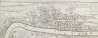
LONDON and WESTMINSTER in the Reign of QUEEN ELIZABETH Anno Dom. 1563
This is a retrospective map of Elizabethan London, giving us an idea of how people in the late 18th Century viewed the Elizabethan capital. The present-day Covent Garden is an area of fields named "Convent Garden”, indicating that the area belonged to the Abbey of St Peter's at Westminster before the dissolution of monasteries in the reign of Henry VIII. The location of Tower Bridge is marked, although the actual bridge was not planned until 1879. This indicates that Londoners were thinking about bridging the river at this point one hundred years before the decisive plan to do so. Wallis, J.