Maps of Camden

Maps of Camden

$title$

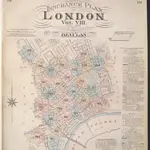
Insurance Plan of London Vol. VIII: Key Plan

1 : 480 This "key plan" indicates coverage of the Goad 1888 series of fire insurance maps of London that were originally produced to aid insurance companies in assessing fire risks. The building footprints, their use (commercial, residential, educational, etc.), the number of floors and the height of the building, as well as construction materials (and thus risk of burning) and special fire hazards (chemicals, kilns, ovens) were documented in order to estimate premiums. Names of individual businesses, property lines, and addresses were also often recorded. Together these maps provide a rich historical shapshot of the commercial activity and urban landscape of towns and cities at the time. The British Library holds a comprehensive collection of fire insurance plans produced by the London-based firm Charles E. Goad Ltd. dating back to 1885. These plans were made for most important towns and cities of the British Isles at the scales of 1:480 (1 inch to 40 feet), as well as many foreign towns at 1:600 (1 inch to 50 feet). Chas E Goad Limited Chas E Goad Limited
$title$

A MAPP of the PARISH of ST GILES'S in the Fields taken from the last Servey, with Corrections and Additions 1-A

1 : 2748 Plan of the parish of St Giles's from the 1720 edition of Stowe's Survey of England. The plan features title in banner at top left, reference table down the right side of the plate, with compass and scale bar at bottom left. The boundaries of the parish are indicated by a pecked line. Blome, Richard
$title$

To the Most Noble JOHN, DUKE OF BEDFORD. This Plan of the United Parishes of ST. GILES in the FIELDS & ST. GEORGE, BLOOMSBURY, 4

1 : 444 This map is dedicated to the Duke of Bedford as this area was the primary metropolitan estate of the Earls ans Dukes of Bedford. Russell was the family name of the Dukes of Bedford, hence Russell Square. Bedford house, built for the 3rd Earl of Bedford in 1586, lay adjacent to Montague house, later to be the British Museum, until 1705-6 when it was demolished. In the lower left hand corner is a vignette of a statue of a Duke of Bedford. A birds eye view of the British Museum and a view of the College of Surgeons are also included as is a statue of C.J Fox right hon, the orator. Wyld, James
$title$

Plan OF THE PARISHES OR DIVISION OF St Giles in the Fields And ST. GEORGE, BLOOMSBURY. 1815 2

1 : 2400 Different pastel colours describe the Parish divisions within St. Giles in the Fields and St. George's, Bloomsbury. A plan of the Burial Ground and Chapel of St. Giles in the Field, adjoining the church yard of St Pancreas, is located in a separate border. Montagu House was sold in 1755 to house the British museum. It was demolished to make way for Smirke''s building in the 1840''s. Hewitt, N.R.
$title$

A MAPP of the Parish of St MARTINS in the FIELDS, taken from ye last survey, with Additions By Blome, Richard.

1 : 3600 This plan of the parish of St Martins in the Fields shows the Banqueting House at Whitehall, the New Exchange on the Strand and Northumberland House.Near the top of the plate, the southern part of today's Leicester Square is indicated with the name of Leicester Fields. The equestrian statue of Charles I is depicted at Charing Cross. A pecked line marks the boundaries with the neighbouring parishes of St James and St Giles. Blome, Richard
$title$

General Plan, shewing the whole line of the Proposed New Street to the British Museum

1 : 4800 A plan of the proposed street running to the British Museum in Bloomsbury. Ingrey & Madeley's
$title$

Plan of Kingsway, From Report of the Royal Commission on cross-river traffic in London, Plate XVIII

$title$

A Plan of the intended improvements from Charing Cross to Bedford Square

A plan of intended improvements from Charing Cross to Bedford Square. Sawyer, Henry
$title$

A Mapp of the Parishes of {ST.CLEMENTS DANES, ST. MARY SAVOY; with the Rolls Liberty and Lincolns Inn. taken From the last Survey with Corrections and Additions 50

1 : 2616 This is the second edition of Blome's map. His name was removed from the cartouche because Strype had taken over as editor of the project. The map shows in elevation the Savoy, Somerset House and gardens, Exeter Exchange and temple, and Lincoln's Inn. The church, St Mary-le-Strand, opposite Somerset House was absent from the earlier edition. It is shown here in plan, but is unnamed and not referred to in the numerical key. Blome, Richard
$title$

Legal London

Hoffman, G.
$title$

London &c. actually survey'd by Wm. Morgan

Ogilby, John
$title$

PART of WESTMINSTER at large shewing the IMPROVEMENTS propos'd about LEICESTER-FIELDS, COVENT-GARDEN, the MEWSE & c.

Trafalgar Square is named Kings Square on this plan and Leicester Square is called Leicester Fields. The new plan is superimposed on the layout of the old. Red lines show new streets in a grid-like formation replacing older and narrower streets and buildings. Gwynn, John
$title$

MAP OF THE Manor of the Savoy AND OF THE LIBERTY OF THE DUCHY OF LANCASTER CALLED The Savoy Liberty, In the County of Middlesex. 1830

1 : 1128 The Savoy Liberty is divided into four wards which are delineated by different pastle shades, an explanation of which appears in the table. St Mary-le-Strand and the Site of the Lyceum Theatre, now in ruins, are shown, as is the ancient site of Burliegh House. Madeley, G. E.
$title$

A Map of the PARISH of ST. PAUL COVENT GARDEN, Shewing the site of BEDFORD HOUSE & GROUNDS. From a Survey, made by WILLIAM LYBORN, in the Year 1686.

1 : 960 A pecked line marks the parish boundary of St Paul's, Covent Carden. Covent Garden was the metropolitan estate of the Russell family: the earls and dukes of Bedford. Bedford House, built in 1586 for the third earl of Bedford, appears to have been an important boundary marker. The development of the area in the 1630s saw it become the first suburb outside the City to be financed by the leasehold system and regulated by building covenants. These factors, combined with Inigo Jones' architecture, made Covent Garden a prototype which was aspired to for the next 250 years. Lyborn, William
$title$

London VII.63 - OS London Town Plan

1 : 1056 Topographic maps Ordnance Survey Ordnance Survey
$title$

London VII.73 - OS London Town Plan

1 : 1056 Topographic maps Ordnance Survey Ordnance Survey
$title$

PLAN OF THE CHARING CROSS & STRAND IMPROVEMENTS 1832

Trafalgar Square is indicated in this plan of Charing Cross as King William Square. The National Gallery of Painting and Sculpture is also indicated on the plan. Founded in 1824, the National Gallery was initially housed in a building in Pall Mall until a more suitable one was built on the north side of Trafalgar Square in 1832-38 to a design by William Wilkins. Wyld, James
$title$

London VII.53 - OS London Town Plan

1 : 1056 Topographic maps Ordnance Survey Ordnance Survey
$title$

A MAPP of the Parish of St PAULS COVENT GARDEN taken from the last Survey By Blome, Richard

Richard Blome was the acting editor of Stow's Survey at this time. Pecked lines show parish boundaries. Bedford House and garden appear on this map. Built in 1586 to replace the Earls of Bedford's earlier mansion on the south side of the Strand, it was demolished in 1706, making way for Southampton Street, Tavistock Street and Tavistock Row. Covent Garden was the metropolitan estate of the Earls and Dukes of Bedford, whose family name was Russell. They later came to own much of Bloomsbury, hence the name of Russell Square. Blome, Richard
$title$

A Plan of the Parish of St Paul's Covent Garden

This is a 19th-Century copy of a map from the beginning of the previous century. It shows Old Bedford House in the Strand. Individual houses around the piazza in Covent Garden are numbered. The New Exchange is marked on the Strand. This was a very smart shopping arcade completed in 1609, taking over much of the trade of the Royal Exchange after it was destroyed in the Great Fire. Historian and biographer John Strype described it in 1720 as ''a place of great resort and trade for the nobility and gentry.''
$title$

Drawn Plan of a new Street from Piccadilly to King Street, Covent Garden

1 : 960 A 19th Century copy of a plan in the Gough Collection, Oxford, dating back to 1766 and showing the new streets connecting Piccadilly to King Street in Covent Garden, London.
$title$

Plan D. PROPOSED NEW STREET from COVENTRY STREET to LONG ACRE. As Revised June 1840.

1 : 852 This plan was ordered by the House of Commons and is titled in the top right border ''FIRST REPORT ON METROPOLIS IMPROVEMENTS - 1840''. It shows the extension of Longacre into Leicester Square, beyond to Princes Street and the widening of Upper St Martin's Lane. The areas coloured pink are those thatneed to be destroyed to make way for the improvements.
$title$

PLAN B. PROPOSED NEW STREET from BOW STREET TO CHARLOTTE STREET. As Revised June 1840

1 : 648 This plan was commissioned by the House of Parliament and shows the proposed new street from Long Acre to Broad Street in the parish of St Giles's, London. Day & Hague
$title$

Drawn Plan of the Property around Leicester Square

1 : 1200 Drawn plan of thr properties around Leicester Square showing the proposed changes to the street plan in red ink and facades of new buildings in elevation at the top and down the left side of the plate.
$title$

The plott for all Thickett ffeilde

This is a copy of a plan dating from 1592 which was made by J. Long and endorsed by Lord Burlington. It covers the land which is now Lincoln's Inn Fields. In the lower section of the plan there is an irregular brown shape upon which is written, ''The Leystall where the Images of waxe were founde''. ''A conduct bed belonging to ''Arundell howse'' is also marked. Arundel House was the location from which Wenceslaus Hollar drew his view of London, published in 1647.
$title$

PLAN OF THE Proposed Improvements at CHARING CROSS, ST. ST MARTIN'S LANE AND Entrance to the Strand

1 : 3600 This plan shows the proposed sites for the National Gallery and the Royal Academy. Basire, James
$title$

PLAN of the late Duke of PORTLAND'S Estate in the neighborhood of SOHO SQUARE - with the names (in red ink) of the Persons to whom the several parts were sold

1 : 900 The title and scale bar of this copy of White's plan appears at the foot of the plate. On the Duke's death, the estate was divided into individual properties and the names of the new landlords are indicated on the plan in red ink. White, John
$title$

London VII.64 - OS London Town Plan

1 : 1056 Topographic maps Ordnance Survey Ordnance Survey
$title$

London VII.74 - OS London Town Plan

1 : 1056 Topographic maps Ordnance Survey Ordnance Survey
$title$

London VII.54 - OS London Town Plan

1 : 1056 Topographic maps Ordnance Survey Ordnance Survey
© MapTiler © OpenStreetMap contributors
How does it work?
These instructions will show you how to find historical maps online.
Getting started
Type the place name in the search box to find the exact location. You can further adjust the search by zooming in and out.
Zoom
Zoom in and out with the buttons or use your mouse or touchpad natively.
Exact Area tool
Click here and draw a rectangle over the map to precisely define the search area.
Set filters
Narrow your search with advanced settings, such as Years (from/to), Fulltext, Publisher, etc.
Results
See the results of your search on the right side. You can scroll down to find more maps of this location.
?

Download OldMapsOnline Mobile