Maps of Tower Hamlets

Insurance Plan of City of London Vol. IV: sheet 90-3
1 : 480 This detailed 1887 plan of London is one of a series of twenty-three sheets in an atlas originally produced to aid insurance companies in assessing fire risks. The building footprints, their use (commercial, residential, educational, etc.), the number of floors and the height of the building, as well as construction materials (and thus risk of burning) and special fire hazards (chemicals, kilns, ovens) were documented in order to estimate premiums. Names of individual businesses, property lines, and addresses were also often recorded. Together these maps provide a rich historical shapshot of the commercial activity and urban landscape of towns and cities at the time. The British Library holds a comprehensive collection of fire insurance plans produced by the London-based firm Charles E. Goad Ltd. dating back to 1885. These plans were made for most important towns and cities of the British Isles at the scales of 1:480 (1 inch to 40 feet), as well as many foreign towns at 1:600 (1 inch to 50 feet). Chas E Goad Limited Chas E Goad Limited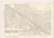
London XI.8 - OS London Town Plan
1 : 1056 Topographic maps Ordnance Survey Ordnance Survey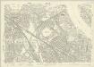
London (1915- Numbered sheets) IX.4 (includes: Bermondsey; Borough Of Greenwich; Deptford St Paul) - 25 Inch Map
1 : 2500 Topographic maps Ordnance Survey Ordnance Survey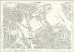
London (Edition of 1894-96) XCI (includes: Bermondsey; Borough Of Greenwich; Deptford St Paul) - 25 Inch Map
1 : 2500 Topographic maps Ordnance Survey Ordnance Survey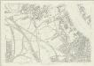
London (First Editions c1850s) LVII (includes: Bermondsey; Borough Of Greenwich; Deptford St Paul) - 25 Inch Map
1 : 2500 Topographic maps Ordnance Survey Ordnance Survey
Insurance Plan of London: sheet 4
This detailed 1889 plan of London is one of a series of six sheets in an atlas originally produced to aid insurance companies in assessing fire risks. The building footprints, their use (commercial, residential, educational, etc.), the number of floors and the height of the building, as well as construction materials (and thus risk of burning) and special fire hazards (chemicals, kilns, ovens) were documented in order to estimate premiums. Names of individual businesses, property lines, and addresses were also often recorded. Together these maps provide a rich historical shapshot of the commercial activity and urban landscape of towns and cities at the time. The British Library holds a comprehensive collection of fire insurance plans produced by the London-based firm Charles E. Goad Ltd. dating back to 1885. These plans were made for most important towns and cities of the British Isles at the scales of 1:480 (1 inch to 40 feet), as well as many foreign towns at 1:600 (1 inch to 50 feet). Chas E Goad Limited Chas E Goad Limited
London South East Vol. J: Key Plan
1 : 4800 This "key plan" indicates coverage of the Goad 1897 series of fire insurance maps of London that were originally produced to aid insurance companies in assessing fire risks. The building footprints, their use (commercial, residential, educational, etc.), the number of floors and the height of the building, as well as construction materials (and thus risk of burning) and special fire hazards (chemicals, kilns, ovens) were documented in order to estimate premiums. Names of individual businesses, property lines, and addresses were also often recorded. Together these maps provide a rich historical shapshot of the commercial activity and urban landscape of towns and cities at the time. The British Library holds a comprehensive collection of fire insurance plans produced by the London-based firm Charles E. Goad Ltd. dating back to 1885. These plans were made for most important towns and cities of the British Isles at the scales of 1:480 (1 inch to 40 feet), as well as many foreign towns at 1:600 (1 inch to 50 feet). Chas E Goad Limited Chas E Goad Limited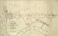
THE SURREY & KENT COMMERCIAL ROADS from the KINGS YARD DEPTFORD, EAST COUNTRY AND COMMERCIAL DOCKS to the Bricklayers Arms, Kent Road & TOOLEY STREET
1 : 7920 Plan for laying down new roads connecting the docks in Deptford to Tooley Street in Bermondsey. The plan is oriented with south at the top and features title and scale bar at lower left and key to colour at top left.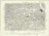
London XI.NE - OS Six-Inch Map
1 : 10560 Topographic maps Ordnance Survey Ordnance Survey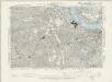
Surrey III.SE - OS Six-Inch Map
1 : 10560 Topographic maps Ordnance Survey Ordnance Survey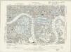
Essex LXXXI.NW - OS Six-Inch Map
1 : 10560 Topographic maps Ordnance Survey Ordnance Survey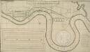
A PROPOSED PLAN FOR WET DOCKS IN WAPPING &c.
1 : 8175 Proposed plan for wet docks at Wapping, with title along the top, key at bottom right, tide table for Blackwall at bottom centre and inset plan of docking and storage facilities at bottom left. This was one of many large scale plans for new docking and shipping facilities for London submitted to Parliament after a Parliamentary Committee reported on the congestion and inadequacy of the London port in 1796. Walker, Ralph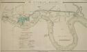
The LONDON DOCKS
1 : 14080 This is Daniel Alexanders original design for the London Docks and Cut. The plan's title and key are at lower left, with the site of the new docks highlighted in blue. Alexander's original design included a 20-acre St. Georges Dock to the west and a seven-acre Shadwell Dock to the east. Each would have their own basin, and be linked by a small Tobacco Dock. Opened in 1805, London Docks were the nearest to the city, and for 21 years all imported tobacco, rice, wine and brandy (except that from the East and West Indies) had to unload there. Alexander, Daniel
Charles Booth's descriptive map of London poverty 1889
Charles Booth
PLAN SHEWING THE PROPOSED LINE of the LONDON AND GREENWICH RAILWAY
1 : 7200 The title of this plan appears at bottom left, with an explanatory note and scale bar at bottom centre. An illustration of the general construction of the railway features at bottom right. The Greenwich line reached Bermondsey in 1836. A year later, it reached London Bridege, which became the first railway terminus in the capital. Wyld, James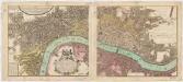
Urbium Londini et West-Monasterii nec non suburbii Southwark accurata ichnographia : in qua viae publicae omnes et singulae, plateae majores et minores, vici, angiporti, porticulae etc. una cum accessionibus aedificiorum, quibus urbs usque ad a. 1736, novissime locupletata est, reprasentantur : ad norman prototypi Londinensis edita curris Hommannianorum Heredum C.P.S.C.M
1 : 5280 Homann Erben (Firm) Homaennischen Erben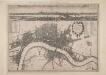
A New Map of the Cities of London and Westminster and Ye Borough of Southwarke with the Suburbs
Large map of London with prospect view of the City from Bankside in a strip above the main plan. Entitled "Prospect of London as it was flourishing before the destruction by fire", the view is based on Hollar's celebrated view of London from Bankside of 1647 and shows London from Worcester House (just west of the Savoy) on the west to Wapping and St Catherine's Docks to the east. The view shows London before the fire being composed almost exclusively of Gothic buildings, Inigo Jones’s Banqueting Hall at Whitehall and the classical restoration of St. Paul’s cathedral being the only examples of Renaissance architecture. The map, with title in cartouche, reference tables at top right and top left and scale bar at bottom centre, is a very minute bird's eye view of the cities of London and Westminster, the borough of Southwark and the suburbs showing London after the fire growing in area faster than ever before. Stepney Church, for example, marks a new point of growth east of the city. Hollar, Wenceslaus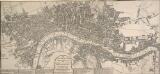
The LONDON GUIDE, or A POCKET PLAN of the CITIES OF LONDON & WESTMINSTER and BOROUGH of SOUTHWARK with the BEW BUILDINGS, &C to the present year
This map of Georgian London was published in John Entick's 1766'A New and Accurate History and Survey of London, Westminster and Southwark.' The title of the map appears in a panel below the plan along with the rates of hackney coaches and water ferries. It extends eastward to include Limehouse, then one of the main centres for shipbuilding in the capital. Bowles, Carington
PLATTE GRONDT Der Verbrande Stadt LONDON
This map was published in Amsterdam aftermath the great fire of 1666. The title in a banner at top right, flanked by City and Royal arms. The design for rebuilding the City is inset in a panel at top left, with an engraved view of the fire in a banner at bottom centre. Below the plan is a description of the fire in Dutch, French and English with a key to streets and buildings. Doornick, Marcus Willemsz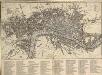
An IMPROVED PLAN of the CITIES of LONDON and WESTMINSTER and BOROUGH of SOUTHWARK, including the NEW BUILDINGS, ROADS &C. to the Present Year 1765.
The title of this pocket map appears along the top, with built-up areas represented by stippling in the City of London, and crosshatching elsewhere. A table of reference appears in a panel below the plan. The map, a later edition of Kitching and Parker's 1765 plan, shows the new bridge and the approaches at Blackfriars. Designed by Robert Mylne, this third bridge spanning the Thames was built between 1760 and 69. The nine semi-elliptical Portland stone arches were replaced from 1860 to 69 by the present structure of five wrought-iron arches each faced with cast iron, and a granite pier designed by Cubitt and Carr. Kitching, Thomas and Parker, Henry
A NEW and Correct PLAN OF THE CITIES AND SUBURBS OF LONDON & WESTMINSTER & BOROUGH OF SOUTHWARK with the COUNTRY adjacent, the NEW BUILDINGS, ROADS &c. to the Year 1766
The title of this map runs along the top of the plan, which shows the new bridge at Blackfriars as "Pitt's Bridge". Designed by Robert Mylne, this third bridge spanning the Thames was built between 1760 and 69. The nine semi-elliptical Portland stone arches were replaced in a hundred years later by the present structure of five wrought-iron arches faced with cast-iron, and a granite pier designed by Cubitt and Carr. Gibson, John
A NEW and Correct PLAN of LONDON WESTMINSTER and SOUTHWARK with the New Buildings to the Year 1770
This map was published in 'A new and complete history and survey of the cities of London and Westminster... revised by Henry Chamberlain.' Only one edition was published and some copies omit the name of the engraver, J. Flyn. The Chelsea Waterworks are shown in Hyde Park. This was the first water-plant to use slow sand filtration to purify the water it supplied. Flyn, J.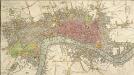
An IMPROVED PLAN of the CITIES of LONDON and WESTMINSTER and BOROUGH of SOUTHWARK, including the NEW BUILDINGS, ROADS &C.
This coloured map shows the built-up area of the City of London as a stippled pattern, with other built-up areas crosshatched. This map is a later edition of Kitching and Parker's 1765 plan, updated to include the new bridge and the approaches at Blackfriars as finally laid out. Designed by Robert Mylne, this third bridge spanning the Thames was built between 1760 and 69. The nine semi-elliptical Portland stone arches were replaced from 1860 to 69 by the present structure of five wrought-iron arches each faced with cast iron, and a granite pier designed by Cubitt and Carr. Kitching, Thomas and Parker, Henry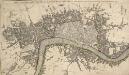
THE CITY GUIDE OR POCKET PLAN OF LONDON, WESTMINSTER And SOUTHWARK with the New Buildings to this Present Year 1764
This pocket map of London based on Rocque's map of 1748.Thetitle appears along the top, with the built-up area in the City of London described by stippling, and other built-up areas by crosshatching. The city boundaries are outlined in colour. The map shows the proposed new bridge at Blackfriars, but not the approaches. Designed by Robert Mylne, this third bridge to span the Thames was built between 1760 and 69. The nine semi-elliptical Portland-stone arches were replaced from 1860 to 69 by Cubitt and Carr’s present structure of five wrought-iron arches faced with cast iron and a granite pier.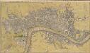
THE CITY GUIDE OR POCKET PLAN OF LONDON, WESTMINSTER And SOUTHWARK With the New Buildings to the Year 1765 121
The title of this map of London runs along the top, with built-up areas represented by stippling within the city boundaries, and hatched elsewhere. Fields and open spaces are shown in green. This first edition of the map does not show the new bridge at Blackfriars, added to the later editions. Bowles, John & Thomas
THE CITY GUIDE OR POCKET PLAN OF LONDON, WESTMINSTER And SOUTHWARK With the New Buildings to the Year 1765 125
The title of this pocket map runs along the top, with the publisher's imprint below the plan. Built-up areas in the City of London are represented by stippling, and by crosshatching outside the city. The map is a later edition Bowles' 1761 plan, with the addition of Queen Anne's Square and Portman Square in Marylebone and the new bridge and approaches at Blackfriars. Designed by Robert Mylne, this third bridge spanning the Thames was built between 1760 and 69. The nine semi-elliptical Portland-stone arches were replaced from 1860 to 69 by the present structure of five wrought-iron arches, each faced with cast iron, and a granite pier designed by Carr and Cubbitt. Bayly, J.
FAIRBURN'S PLAN of the proposed WET-DOCKS AND CUT from NEW GRAVEL LANE to BLACKWALL
1 : 16896 The plan's title and publisher's imprint appear at bottom left, with a compass star, key and scale bar at bottom centre.The boundary of the area to be developed is highlighted in red. After a Parliamentary Select Committee in 1796 condemned the congestion at the Port of London, a number of large-scale projects for new docking and shipping facilities were submitted to Parliament. Fairburn's plan illustrates the London merchants' scheme. It consists of an entrance dock that could accommodate 33 loaded ships, two main docks that would accommodate a total of 355 ships and a separate dock for lighters. The plan also included the creation of the 2" 3/4 mile long cut from Wapping to Blackwall. An improved version of this scheme would eventually materialise as the London Docks. Fairburn, John
A New Map of the Cities of London and Westminster and Ye Borough of Southwarke with their Suburbs
This is a later edition of Hollar's map of London of 1675 without the prospect view of the City entitled "Prospect of London as it was flourishing before the destruction by fire" that featured in the first edition. The map, with title in cartouche, reference tables and scale bar, is a very minute bird’s eye view of the cities of London and Westminster, with the Borough of Southwark and suburbs showing London after the fire growing in area faster than ever before, with former satellite villages fast becoming mere localities in the urban sprawl. Stepney church, for example, marks a new point of growth east of the city. Hollar, Wenceslaus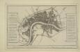
Plan of the city and suburbs of London as fortified by Order of Parliament in the years 1642 and 1643