Maps of Southwark

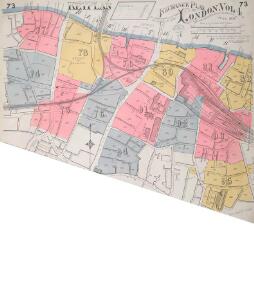
Insurance Plan of City of London Vol. IV: Key Plan 1
1 : 480 This "key plan" indicates coverage of the Goad 1887 series of fire insurance maps of London that were originally produced to aid insurance companies in assessing fire risks. The building footprints, their use (commercial, residential, educational, etc.), the number of floors and the height of the building, as well as construction materials (and thus risk of burning) and special fire hazards (chemicals, kilns, ovens) were documented in order to estimate premiums. Names of individual businesses, property lines, and addresses were also often recorded. Together these maps provide a rich historical shapshot of the commercial activity and urban landscape of towns and cities at the time. The British Library holds a comprehensive collection of fire insurance plans produced by the London-based firm Charles E. Goad Ltd. dating back to 1885. These plans were made for most important towns and cities of the British Isles at the scales of 1:480 (1 inch to 40 feet), as well as many foreign towns at 1:600 (1 inch to 50 feet). Chas E Goad Limited Chas E Goad Limited
Plan of the Cities of London and Westminster, the Borough of Southwark and parts adjoining, shewing every house. By R. Horwood. [Scale, about 25 inches = 1 mile]
Horwood, Richard
Plan for the improvement of the approaches on the south side of New London Bridge] Part B
1 : 960 A section at the base of the map shows the line of ascent of the new road from the centre of the first arch on the Surrey side of the river, and the high-water mark of the Thames at this point. Blue flags mark the lower ground level before the line of ascent to the bridge. Gwilt, George
London VII.86 - OS London Town Plan
1 : 1056 Topographic maps Ordnance Survey Ordnance Survey
London VII.85 - OS London Town Plan
1 : 1056 Topographic maps Ordnance Survey Ordnance Survey
Plan for preventing the Traffic to the WHARFS AND PREMISES IN TOOLEY STREET being impeded by that proceeding TO THE FOUR RAILWAY STATIONS
This is a plan for improving the approaches to London Bridge Station, then the terminus for the Eastern, Brighton, Croydon and Greenwich railways. The plan is oriented to the south. It's title features at bottom left, with an explanatory note at middle right. The current approach to the station is highlighted in yellow with the proposed improvements outlined in red. Above the plan are level sections of the present and proposed approaches. Allen, George
Insurance Plan of City of London Vol. IV: sheet 91
1 : 480 This detailed 1887 plan of London is one of a series of twenty-three sheets in an atlas originally produced to aid insurance companies in assessing fire risks. The building footprints, their use (commercial, residential, educational, etc.), the number of floors and the height of the building, as well as construction materials (and thus risk of burning) and special fire hazards (chemicals, kilns, ovens) were documented in order to estimate premiums. Names of individual businesses, property lines, and addresses were also often recorded. Together these maps provide a rich historical shapshot of the commercial activity and urban landscape of towns and cities at the time. The British Library holds a comprehensive collection of fire insurance plans produced by the London-based firm Charles E. Goad Ltd. dating back to 1885. These plans were made for most important towns and cities of the British Isles at the scales of 1:480 (1 inch to 40 feet), as well as many foreign towns at 1:600 (1 inch to 50 feet). Chas E Goad Limited Chas E Goad Limited
Insurance Plan of London. Goad
London: Chas. E. Goad
Insurance Plan of City of London Vol. IV: sheet 75
1 : 480 This detailed 1887 plan of London is one of a series of twenty-three sheets in an atlas originally produced to aid insurance companies in assessing fire risks. The building footprints, their use (commercial, residential, educational, etc.), the number of floors and the height of the building, as well as construction materials (and thus risk of burning) and special fire hazards (chemicals, kilns, ovens) were documented in order to estimate premiums. Names of individual businesses, property lines, and addresses were also often recorded. Together these maps provide a rich historical shapshot of the commercial activity and urban landscape of towns and cities at the time. The British Library holds a comprehensive collection of fire insurance plans produced by the London-based firm Charles E. Goad Ltd. dating back to 1885. These plans were made for most important towns and cities of the British Isles at the scales of 1:480 (1 inch to 40 feet), as well as many foreign towns at 1:600 (1 inch to 50 feet). Chas E Goad Limited Chas E Goad Limited
Insurance Plan of City of London Vol. IV: sheet 80
1 : 480 This detailed 1887 plan of London is one of a series of twenty-three sheets in an atlas originally produced to aid insurance companies in assessing fire risks. The building footprints, their use (commercial, residential, educational, etc.), the number of floors and the height of the building, as well as construction materials (and thus risk of burning) and special fire hazards (chemicals, kilns, ovens) were documented in order to estimate premiums. Names of individual businesses, property lines, and addresses were also often recorded. Together these maps provide a rich historical shapshot of the commercial activity and urban landscape of towns and cities at the time. The British Library holds a comprehensive collection of fire insurance plans produced by the London-based firm Charles E. Goad Ltd. dating back to 1885. These plans were made for most important towns and cities of the British Isles at the scales of 1:480 (1 inch to 40 feet), as well as many foreign towns at 1:600 (1 inch to 50 feet). Chas E Goad Limited Chas E Goad Limited
Insurance Plan of City of London Vol. IV: sheet 78
1 : 480 This detailed 1887 plan of London is one of a series of twenty-three sheets in an atlas originally produced to aid insurance companies in assessing fire risks. The building footprints, their use (commercial, residential, educational, etc.), the number of floors and the height of the building, as well as construction materials (and thus risk of burning) and special fire hazards (chemicals, kilns, ovens) were documented in order to estimate premiums. Names of individual businesses, property lines, and addresses were also often recorded. Together these maps provide a rich historical shapshot of the commercial activity and urban landscape of towns and cities at the time. The British Library holds a comprehensive collection of fire insurance plans produced by the London-based firm Charles E. Goad Ltd. dating back to 1885. These plans were made for most important towns and cities of the British Isles at the scales of 1:480 (1 inch to 40 feet), as well as many foreign towns at 1:600 (1 inch to 50 feet). Chas E Goad Limited Chas E Goad Limited
Insurance Plan of City of London Vol. IV: sheet 81
1 : 480 This detailed 1887 plan of London is one of a series of twenty-three sheets in an atlas originally produced to aid insurance companies in assessing fire risks. The building footprints, their use (commercial, residential, educational, etc.), the number of floors and the height of the building, as well as construction materials (and thus risk of burning) and special fire hazards (chemicals, kilns, ovens) were documented in order to estimate premiums. Names of individual businesses, property lines, and addresses were also often recorded. Together these maps provide a rich historical shapshot of the commercial activity and urban landscape of towns and cities at the time. The British Library holds a comprehensive collection of fire insurance plans produced by the London-based firm Charles E. Goad Ltd. dating back to 1885. These plans were made for most important towns and cities of the British Isles at the scales of 1:480 (1 inch to 40 feet), as well as many foreign towns at 1:600 (1 inch to 50 feet). Chas E Goad Limited Chas E Goad Limited
Insurance Plan of City of London Vol. IV: sheet 76-1
1 : 480 This detailed 1887 plan of London is one of a series of twenty-three sheets in an atlas originally produced to aid insurance companies in assessing fire risks. The building footprints, their use (commercial, residential, educational, etc.), the number of floors and the height of the building, as well as construction materials (and thus risk of burning) and special fire hazards (chemicals, kilns, ovens) were documented in order to estimate premiums. Names of individual businesses, property lines, and addresses were also often recorded. Together these maps provide a rich historical shapshot of the commercial activity and urban landscape of towns and cities at the time. The British Library holds a comprehensive collection of fire insurance plans produced by the London-based firm Charles E. Goad Ltd. dating back to 1885. These plans were made for most important towns and cities of the British Isles at the scales of 1:480 (1 inch to 40 feet), as well as many foreign towns at 1:600 (1 inch to 50 feet). Chas E Goad Limited Chas E Goad Limited
Insurance Plan of City of London Vol. IV: sheet 94-1
1 : 480 This detailed 1887 plan of London is one of a series of twenty-three sheets in an atlas originally produced to aid insurance companies in assessing fire risks. The building footprints, their use (commercial, residential, educational, etc.), the number of floors and the height of the building, as well as construction materials (and thus risk of burning) and special fire hazards (chemicals, kilns, ovens) were documented in order to estimate premiums. Names of individual businesses, property lines, and addresses were also often recorded. Together these maps provide a rich historical shapshot of the commercial activity and urban landscape of towns and cities at the time. The British Library holds a comprehensive collection of fire insurance plans produced by the London-based firm Charles E. Goad Ltd. dating back to 1885. These plans were made for most important towns and cities of the British Isles at the scales of 1:480 (1 inch to 40 feet), as well as many foreign towns at 1:600 (1 inch to 50 feet). Chas E Goad Limited Chas E Goad Limited
Insurance Plan of City of London Vol. IV: sheet 79
1 : 480 This detailed 1887 plan of London is one of a series of twenty-three sheets in an atlas originally produced to aid insurance companies in assessing fire risks. The building footprints, their use (commercial, residential, educational, etc.), the number of floors and the height of the building, as well as construction materials (and thus risk of burning) and special fire hazards (chemicals, kilns, ovens) were documented in order to estimate premiums. Names of individual businesses, property lines, and addresses were also often recorded. Together these maps provide a rich historical shapshot of the commercial activity and urban landscape of towns and cities at the time. The British Library holds a comprehensive collection of fire insurance plans produced by the London-based firm Charles E. Goad Ltd. dating back to 1885. These plans were made for most important towns and cities of the British Isles at the scales of 1:480 (1 inch to 40 feet), as well as many foreign towns at 1:600 (1 inch to 50 feet). Chas E Goad Limited Chas E Goad Limited
Insurance Plan of City of London Vol. IV: sheet 92
1 : 480 This detailed 1887 plan of London is one of a series of twenty-three sheets in an atlas originally produced to aid insurance companies in assessing fire risks. The building footprints, their use (commercial, residential, educational, etc.), the number of floors and the height of the building, as well as construction materials (and thus risk of burning) and special fire hazards (chemicals, kilns, ovens) were documented in order to estimate premiums. Names of individual businesses, property lines, and addresses were also often recorded. Together these maps provide a rich historical shapshot of the commercial activity and urban landscape of towns and cities at the time. The British Library holds a comprehensive collection of fire insurance plans produced by the London-based firm Charles E. Goad Ltd. dating back to 1885. These plans were made for most important towns and cities of the British Isles at the scales of 1:480 (1 inch to 40 feet), as well as many foreign towns at 1:600 (1 inch to 50 feet). Chas E Goad Limited Chas E Goad Limited
Insurance Plan of City of London Vol. IV: sheet 93
1 : 480 This detailed 1887 plan of London is one of a series of twenty-three sheets in an atlas originally produced to aid insurance companies in assessing fire risks. The building footprints, their use (commercial, residential, educational, etc.), the number of floors and the height of the building, as well as construction materials (and thus risk of burning) and special fire hazards (chemicals, kilns, ovens) were documented in order to estimate premiums. Names of individual businesses, property lines, and addresses were also often recorded. Together these maps provide a rich historical shapshot of the commercial activity and urban landscape of towns and cities at the time. The British Library holds a comprehensive collection of fire insurance plans produced by the London-based firm Charles E. Goad Ltd. dating back to 1885. These plans were made for most important towns and cities of the British Isles at the scales of 1:480 (1 inch to 40 feet), as well as many foreign towns at 1:600 (1 inch to 50 feet). Chas E Goad Limited Chas E Goad Limited
London South East Vol. J: sheet 5
1 : 480 This detailed 1897 plan of London is one of a series of twenty-seven sheets in an atlas originally produced to aid insurance companies in assessing fire risks. The building footprints, their use (commercial, residential, educational, etc.), the number of floors and the height of the building, as well as construction materials (and thus risk of burning) and special fire hazards (chemicals, kilns, ovens) were documented in order to estimate premiums. Names of individual businesses, property lines, and addresses were also often recorded. Together these maps provide a rich historical shapshot of the commercial activity and urban landscape of towns and cities at the time. The British Library holds a comprehensive collection of fire insurance plans produced by the London-based firm Charles E. Goad Ltd. dating back to 1885. These plans were made for most important towns and cities of the British Isles at the scales of 1:480 (1 inch to 40 feet), as well as many foreign towns at 1:600 (1 inch to 50 feet). Chas E Goad Limited Chas E Goad Limited
Insurance Plan of London Vol. VII: sheet 152
1 : 480 This detailed 1887 plan of London is one of a series of twenty-six sheets in an atlas originally produced to aid insurance companies in assessing fire risks. The building footprints, their use (commercial, residential, educational, etc.), the number of floors and the height of the building, as well as construction materials (and thus risk of burning) and special fire hazards (chemicals, kilns, ovens) were documented in order to estimate premiums. Names of individual businesses, property lines, and addresses were also often recorded. Together these maps provide a rich historical shapshot of the commercial activity and urban landscape of towns and cities at the time. The British Library holds a comprehensive collection of fire insurance plans produced by the London-based firm Charles E. Goad Ltd. dating back to 1885. These plans were made for most important towns and cities of the British Isles at the scales of 1:480 (1 inch to 40 feet), as well as many foreign towns at 1:600 (1 inch to 50 feet). Chas E Goad Limited Chas E Goad Limited
Insurance Plan of City of London Vol. IV: sheet 77
1 : 480 This detailed 1887 plan of London is one of a series of twenty-three sheets in an atlas originally produced to aid insurance companies in assessing fire risks. The building footprints, their use (commercial, residential, educational, etc.), the number of floors and the height of the building, as well as construction materials (and thus risk of burning) and special fire hazards (chemicals, kilns, ovens) were documented in order to estimate premiums. Names of individual businesses, property lines, and addresses were also often recorded. Together these maps provide a rich historical shapshot of the commercial activity and urban landscape of towns and cities at the time. The British Library holds a comprehensive collection of fire insurance plans produced by the London-based firm Charles E. Goad Ltd. dating back to 1885. These plans were made for most important towns and cities of the British Isles at the scales of 1:480 (1 inch to 40 feet), as well as many foreign towns at 1:600 (1 inch to 50 feet). Chas E Goad Limited Chas E Goad Limited
Insurance Plan of London Vol. X: sheet 252-2
1 : 480 This detailed 1889 plan of London is one of a series of thirty-five sheets in an atlas originally produced to aid insurance companies in assessing fire risks. The building footprints, their use (commercial, residential, educational, etc.), the number of floors and the height of the building, as well as construction materials (and thus risk of burning) and special fire hazards (chemicals, kilns, ovens) were documented in order to estimate premiums. Names of individual businesses, property lines, and addresses were also often recorded. Together these maps provide a rich historical shapshot of the commercial activity and urban landscape of towns and cities at the time. The British Library holds a comprehensive collection of fire insurance plans produced by the London-based firm Charles E. Goad Ltd. dating back to 1885. These plans were made for most important towns and cities of the British Isles at the scales of 1:480 (1 inch to 40 feet), as well as many foreign towns at 1:600 (1 inch to 50 feet). Chas E Goad Limited Chas E Goad Limited
Insurance Plan of London Vol. X: sheet 250
1 : 480 This detailed 1889 plan of London is one of a series of thirty-five sheets in an atlas originally produced to aid insurance companies in assessing fire risks. The building footprints, their use (commercial, residential, educational, etc.), the number of floors and the height of the building, as well as construction materials (and thus risk of burning) and special fire hazards (chemicals, kilns, ovens) were documented in order to estimate premiums. Names of individual businesses, property lines, and addresses were also often recorded. Together these maps provide a rich historical shapshot of the commercial activity and urban landscape of towns and cities at the time. The British Library holds a comprehensive collection of fire insurance plans produced by the London-based firm Charles E. Goad Ltd. dating back to 1885. These plans were made for most important towns and cities of the British Isles at the scales of 1:480 (1 inch to 40 feet), as well as many foreign towns at 1:600 (1 inch to 50 feet). Chas E Goad Limited Chas E Goad Limited
London South East Vol. J: sheet 6
1 : 480 This detailed 1897 plan of London is one of a series of twenty-seven sheets in an atlas originally produced to aid insurance companies in assessing fire risks. The building footprints, their use (commercial, residential, educational, etc.), the number of floors and the height of the building, as well as construction materials (and thus risk of burning) and special fire hazards (chemicals, kilns, ovens) were documented in order to estimate premiums. Names of individual businesses, property lines, and addresses were also often recorded. Together these maps provide a rich historical shapshot of the commercial activity and urban landscape of towns and cities at the time. The British Library holds a comprehensive collection of fire insurance plans produced by the London-based firm Charles E. Goad Ltd. dating back to 1885. These plans were made for most important towns and cities of the British Isles at the scales of 1:480 (1 inch to 40 feet), as well as many foreign towns at 1:600 (1 inch to 50 feet). Chas E Goad Limited Chas E Goad Limited
Insurance Plan of City of London Vol. IV: sheet 74-1
1 : 480 This detailed 1887 plan of London is one of a series of twenty-three sheets in an atlas originally produced to aid insurance companies in assessing fire risks. The building footprints, their use (commercial, residential, educational, etc.), the number of floors and the height of the building, as well as construction materials (and thus risk of burning) and special fire hazards (chemicals, kilns, ovens) were documented in order to estimate premiums. Names of individual businesses, property lines, and addresses were also often recorded. Together these maps provide a rich historical shapshot of the commercial activity and urban landscape of towns and cities at the time. The British Library holds a comprehensive collection of fire insurance plans produced by the London-based firm Charles E. Goad Ltd. dating back to 1885. These plans were made for most important towns and cities of the British Isles at the scales of 1:480 (1 inch to 40 feet), as well as many foreign towns at 1:600 (1 inch to 50 feet). Chas E Goad Limited Chas E Goad Limited
Insurance Plan of City of London Vol. IV: sheet 95-1
1 : 480 This detailed 1887 plan of London is one of a series of twenty-three sheets in an atlas originally produced to aid insurance companies in assessing fire risks. The building footprints, their use (commercial, residential, educational, etc.), the number of floors and the height of the building, as well as construction materials (and thus risk of burning) and special fire hazards (chemicals, kilns, ovens) were documented in order to estimate premiums. Names of individual businesses, property lines, and addresses were also often recorded. Together these maps provide a rich historical shapshot of the commercial activity and urban landscape of towns and cities at the time. The British Library holds a comprehensive collection of fire insurance plans produced by the London-based firm Charles E. Goad Ltd. dating back to 1885. These plans were made for most important towns and cities of the British Isles at the scales of 1:480 (1 inch to 40 feet), as well as many foreign towns at 1:600 (1 inch to 50 feet). Chas E Goad Limited Chas E Goad Limited
Insurance Plan of London Vol. X: sheet 251
1 : 480 This detailed 1889 plan of London is one of a series of thirty-five sheets in an atlas originally produced to aid insurance companies in assessing fire risks. The building footprints, their use (commercial, residential, educational, etc.), the number of floors and the height of the building, as well as construction materials (and thus risk of burning) and special fire hazards (chemicals, kilns, ovens) were documented in order to estimate premiums. Names of individual businesses, property lines, and addresses were also often recorded. Together these maps provide a rich historical shapshot of the commercial activity and urban landscape of towns and cities at the time. The British Library holds a comprehensive collection of fire insurance plans produced by the London-based firm Charles E. Goad Ltd. dating back to 1885. These plans were made for most important towns and cities of the British Isles at the scales of 1:480 (1 inch to 40 feet), as well as many foreign towns at 1:600 (1 inch to 50 feet). Chas E Goad Limited Chas E Goad Limited
Insurance Plan of London Vol. X: sheet 258-4
1 : 480 This detailed 1889 plan of London is one of a series of thirty-five sheets in an atlas originally produced to aid insurance companies in assessing fire risks. The building footprints, their use (commercial, residential, educational, etc.), the number of floors and the height of the building, as well as construction materials (and thus risk of burning) and special fire hazards (chemicals, kilns, ovens) were documented in order to estimate premiums. Names of individual businesses, property lines, and addresses were also often recorded. Together these maps provide a rich historical shapshot of the commercial activity and urban landscape of towns and cities at the time. The British Library holds a comprehensive collection of fire insurance plans produced by the London-based firm Charles E. Goad Ltd. dating back to 1885. These plans were made for most important towns and cities of the British Isles at the scales of 1:480 (1 inch to 40 feet), as well as many foreign towns at 1:600 (1 inch to 50 feet). Chas E Goad Limited Chas E Goad Limited
Plan of Properties in the Layton's Buildings
1 : 1200 Drawn plan of the commercial premises, workshops, stable yards and coach houses in the Layton's buildings on Borough High Street, Southwark. Orientation points are marked on the margins of the sheet.
Insurance Plan of City of London Vol. IV: sheet 95-2
1 : 480 This detailed 1887 plan of London is one of a series of twenty-three sheets in an atlas originally produced to aid insurance companies in assessing fire risks. The building footprints, their use (commercial, residential, educational, etc.), the number of floors and the height of the building, as well as construction materials (and thus risk of burning) and special fire hazards (chemicals, kilns, ovens) were documented in order to estimate premiums. Names of individual businesses, property lines, and addresses were also often recorded. Together these maps provide a rich historical shapshot of the commercial activity and urban landscape of towns and cities at the time. The British Library holds a comprehensive collection of fire insurance plans produced by the London-based firm Charles E. Goad Ltd. dating back to 1885. These plans were made for most important towns and cities of the British Isles at the scales of 1:480 (1 inch to 40 feet), as well as many foreign towns at 1:600 (1 inch to 50 feet). Chas E Goad Limited Chas E Goad Limited