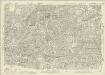
Maps of Islington

Insurance Plan of City of London Vol. III: sheet 60
1 : 480 This detailed 1887 plan of London is one of a series of twenty-three sheets in an atlas originally produced to aid insurance companies in assessing fire risks. The building footprints, their use (commercial, residential, educational, etc.), the number of floors and the height of the building, as well as construction materials (and thus risk of burning) and special fire hazards (chemicals, kilns, ovens) were documented in order to estimate premiums. Names of individual businesses, property lines, and addresses were also often recorded. Together these maps provide a rich historical shapshot of the commercial activity and urban landscape of towns and cities at the time. The British Library holds a comprehensive collection of fire insurance plans produced by the London-based firm Charles E. Goad Ltd. dating back to 1885. These plans were made for most important towns and cities of the British Isles at the scales of 1:480 (1 inch to 40 feet), as well as many foreign towns at 1:600 (1 inch to 50 feet). Chas E Goad Limited Chas E Goad Limited
A PLAN OF THE CHURCH OF ST. PETER UPON CORNHILL, ITS CEMETERY &c.
1 : 72 The title of this plan runs down the right side of the plate, with the scale bar at bottom centre and the names of the parishioners reported on their seats they in the church pews. Erected on the site of an old Roman basilica in AD179, St Peter's church burned down in the great fire of 1666 and was rebuilt by Christopher Wren in the years 1675/81. In the Middle Ages the church housed a large library and a grammar school. Wilkinson, Robert
Insurance Plan of City of London Vol. III: sheet 61
1 : 480 This detailed 1887 plan of London is one of a series of twenty-three sheets in an atlas originally produced to aid insurance companies in assessing fire risks. The building footprints, their use (commercial, residential, educational, etc.), the number of floors and the height of the building, as well as construction materials (and thus risk of burning) and special fire hazards (chemicals, kilns, ovens) were documented in order to estimate premiums. Names of individual businesses, property lines, and addresses were also often recorded. Together these maps provide a rich historical shapshot of the commercial activity and urban landscape of towns and cities at the time. The British Library holds a comprehensive collection of fire insurance plans produced by the London-based firm Charles E. Goad Ltd. dating back to 1885. These plans were made for most important towns and cities of the British Isles at the scales of 1:480 (1 inch to 40 feet), as well as many foreign towns at 1:600 (1 inch to 50 feet). Chas E Goad Limited Chas E Goad Limited
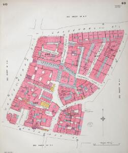
Insurance Plan of City of London Vol. III: sheet 67
1 : 480 This detailed 1887 plan of London is one of a series of twenty-three sheets in an atlas originally produced to aid insurance companies in assessing fire risks. The building footprints, their use (commercial, residential, educational, etc.), the number of floors and the height of the building, as well as construction materials (and thus risk of burning) and special fire hazards (chemicals, kilns, ovens) were documented in order to estimate premiums. Names of individual businesses, property lines, and addresses were also often recorded. Together these maps provide a rich historical shapshot of the commercial activity and urban landscape of towns and cities at the time. The British Library holds a comprehensive collection of fire insurance plans produced by the London-based firm Charles E. Goad Ltd. dating back to 1885. These plans were made for most important towns and cities of the British Isles at the scales of 1:480 (1 inch to 40 feet), as well as many foreign towns at 1:600 (1 inch to 50 feet). Chas E Goad Limited Chas E Goad Limited
Insurance Plan of City of London Vol. III: sheet 59
1 : 480 This detailed 1887 plan of London is one of a series of twenty-three sheets in an atlas originally produced to aid insurance companies in assessing fire risks. The building footprints, their use (commercial, residential, educational, etc.), the number of floors and the height of the building, as well as construction materials (and thus risk of burning) and special fire hazards (chemicals, kilns, ovens) were documented in order to estimate premiums. Names of individual businesses, property lines, and addresses were also often recorded. Together these maps provide a rich historical shapshot of the commercial activity and urban landscape of towns and cities at the time. The British Library holds a comprehensive collection of fire insurance plans produced by the London-based firm Charles E. Goad Ltd. dating back to 1885. These plans were made for most important towns and cities of the British Isles at the scales of 1:480 (1 inch to 40 feet), as well as many foreign towns at 1:600 (1 inch to 50 feet). Chas E Goad Limited Chas E Goad Limited
A PLAN of all the HOUSES destroyed and damaged by the GREAT FIRE which began in BISHOPSGATE STREET on Thursday Nov.r 7th 1765.
1 : 540 Small plan of the part of Cornhill damaged by the fire of November 1765. The plan features title along the top, scale bar at top left and imprint below the plan. The fire which broke out in the early hours of the morning in Mr. Rutland's peruke making shop in Bishopsgate Street, destroyed forty nine houses damaging a further fifteen. Nicol, William & Jeffrey, Thomas
Insurance Plan of City of London Vol. III: sheet 55
1 : 480 This detailed 1887 plan of London is one of a series of twenty-three sheets in an atlas originally produced to aid insurance companies in assessing fire risks. The building footprints, their use (commercial, residential, educational, etc.), the number of floors and the height of the building, as well as construction materials (and thus risk of burning) and special fire hazards (chemicals, kilns, ovens) were documented in order to estimate premiums. Names of individual businesses, property lines, and addresses were also often recorded. Together these maps provide a rich historical shapshot of the commercial activity and urban landscape of towns and cities at the time. The British Library holds a comprehensive collection of fire insurance plans produced by the London-based firm Charles E. Goad Ltd. dating back to 1885. These plans were made for most important towns and cities of the British Isles at the scales of 1:480 (1 inch to 40 feet), as well as many foreign towns at 1:600 (1 inch to 50 feet). Chas E Goad Limited Chas E Goad Limited
A MAPP OF LIME STREET WARD taken from ye last Survey & Corrected
1 : 3600 This plan was published in Strype's annotated 1720 edition of Stow's "Survey of England". The title features in banner at top left, with compass star at middle left, scale bar at bottom right and key to streets, yards, squares and public places in panel at top right. Leaden Hall market and other prominent buildings are shown pictorially. Blome, Richard
LANGBORNE WARD AND CANDLEWICK WARD with their Divisions into Parishes According to a New SURVEY
1 : 2760 This plan was published in William Maitland's 'History of London from its Foundation to the Present Day'. The plan's title features at top centre, flanked by the heraldic arms of Joseph Kankey, Alderman of Longborn, and Charles Asgill, Alderman of Candlewick. Illustrated views of St Alhallon's church appear at top and bottom left, with a view of St Clement's church at bottom centre and St Mary's church at bottom right. Maitland's ward plans were largely derived from Strype's plans, with the illustrations copied from West & Tow's 1736 'Prospect Views of Ancient Churches'. Cole, B.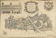
A New and Corrected PLAN of LIMESTREET WARD with its Divisions into Parishes according to a NEW Survey
1 : 3600 This plan was published in William Maitland's 'History of London from its Foundation to the Present Day'. The title features in a cartouche at top centre, with the Arms of John Porter, Alderman of Lime Street, at top right. The scale bar is at bottom right, compass star at bottom left, and an illustrated view of the facade of Leaden Hall market at top left. Maitland's ward plans were largely derived from Strype's plans, with the illustrations copied from West Tow's 'Prospect Views of Ancient Churches' of 1736. Cole, B.
London VII.66 - OS London Town Plan
1 : 1056 Topographic maps Ordnance Survey Ordnance Survey
A PLAN for A STREET Eighty Feet wide, and Fifty Feet deep, on each side, between the ROYAL EXCHANGE AND LONDON BRIDGE
1 : 7200 This is a plan for a new street connecting the Royal Exchange to London Bridge. The different colours used on this plan denote the property of the different wards of Cornhill, Langbourn, Candlewick and Bridge. In the top left corner is a manuscript note about the ''peers'' (supporting piers) of Southwark Bridge. Luffman, John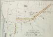
A Plan for a Street from MOORGATE to the LONDON BRIDGE.
1 : 6000 This is a plan showing an intended street from Moorgate to London Bridge. Higgins, J.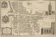
BILLINSGATE WARD AND BRIDGE WARD WITHIN with their Divisions into PARISHES According to a new SURVEY
1 : 1800 This plan was published in William Maitland's 'History of London from its Foundation to the Present Time'. The plan's title features in cartouche at bottom left, with the arms of William Beckford, Alderman of Billinsgate, and William Stephenson, Aldermen of Bridge Ward, down the left side of the plate. The compass star and scale bar are at top centre. At top left and bottom right are illustrated views of the churches of St Mary and St. Botolph. Engraved by Cole, Maitand's ward plans were largely derived from Strype's plans, with the illustrations copied from West Tow's 'Prospect Views of Ancient Churches' of 1736. Cole, B.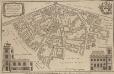
ALDGATE
1 : 2173 This plan was published in William Maitland's 'History of London from Its Foundation to the Present Time'. The plan's title features in cartouche at top left, with the arms of Alderman Robert Scott, to whom the plan is dedicated, at top right. The compass star is included at middle left, with a view of St James' Duke Place at bottom right. The scale bar is at bottom centre with a view of the Church of St Catherine Coleman at bottom right. Engraved by Cole, Maitland's ward plans were largely derived from Strype's plans, with the illustrations copied from West : Tow's 1736 'Prospect Views of Ancient Churches'. Cole, B.
ALDGATE WARD with its Division into Parishes. Taken from the last Survey with Corrections & Alterations 4A
1 : 2400 This map was published in Strype's first annotated edition of Stow's 'Survey of England'. The map's title features in ornamental cartouche at top left, with key to streets, yards, halls, courts and private properties in a table at top centre. The compass star appears at bottom left and scale bar at bottom right. Blome, Richard
BROADSTREET WARD Divided into Parishes accoording to a NEW SURVEY CORNHILL WARD Divided into Parishes accoording to a NEW SURVEY.
1 : 1440 This plan was published in William Maitland's 'History of London from its Foundation to the Present Time'. Its title appears on the left side of the plate, along with an illustrated view of the parish church of St Christopher, and the heraldic arms of Francis Cokaine, Alderman of Cornhill ward. Illustrated views of the churches of St Bartholomew and St Bennet Finch appear down the right side of the plate. Maitland's ward plans were largely derived from Strype's, with the illustrations copied from West & Tow's 1736 'Prospect Views of Ancient Churches'. Cole, B.
BROADSTREET Ward with its divisions into Parishes taken from the last Survey with Corrections and Additions CORNHILL Ward with its divisions into Parishes taken from the last Survey 12B
1 : 1656 This map is taken from Strype's 1755 annotated edition of Stow's 'Survey of England'. The plan's title features in banner at top left and in cartouche at bottom right. The compass star appears at bottom left, with scale bar at bottom right and the keys to streets, yards, halls, courts and private properties in tables down both sides of the plan. The Royal Exchange and other prominent buildings are shown pictorially. First published in 1720, Strype's ward plans were carefully updated for this edition. Blome, Richard
BROADSTREET Ward with its divisions into Parishes taken from the last Survey with Corrections and Additions CORNHILL Ward with its divisions into Parishes taken from the last Survey 12A
1 : 1656 This map was published in Strype's first annotated edition of Stow's "Survey of England". The plan's title features in banner at top left and in cartouche at bottom right. The compass star is at bottom left, with scale bar at bottom right and a key to streets, yards, halls, courts and private properties in tables down both sides of the plan.The Royal Exchange and other prominent buildings are shown pictorially. Blome, Richard
BILLINSGATE and BRIDGE WARD Within with its Division into Parishes taken from the last Survey. 6a
1 : 2400 This map is taken from Strype's first annotated edition of Stow's 'Survey of England'. The map's title appears in ornamental cartouche at top centre, with a key to streets, yards, halls, courts and private properties in a table below the title. The plan also features compass star at bottom left and scale bar at bottom right. Prominent buildings and ships sailing along the Thames are represented pictorially. Blome, Richard
Plan of CORNHILL WARD Surveyed October 1833
1 : 3000 This plan's title and imprint appear at bottom left, with scale bar at bottom centre and compass star at bottom left. It shows part of the ground plans of the Royal Exchange, and St Michael's and St Peter's churches. Agnell, Samuel
Insurance Plan of City of London Vol. III: sheet 56
1 : 480 This detailed 1887 plan of London is one of a series of twenty-three sheets in an atlas originally produced to aid insurance companies in assessing fire risks. The building footprints, their use (commercial, residential, educational, etc.), the number of floors and the height of the building, as well as construction materials (and thus risk of burning) and special fire hazards (chemicals, kilns, ovens) were documented in order to estimate premiums. Names of individual businesses, property lines, and addresses were also often recorded. Together these maps provide a rich historical shapshot of the commercial activity and urban landscape of towns and cities at the time. The British Library holds a comprehensive collection of fire insurance plans produced by the London-based firm Charles E. Goad Ltd. dating back to 1885. These plans were made for most important towns and cities of the British Isles at the scales of 1:480 (1 inch to 40 feet), as well as many foreign towns at 1:600 (1 inch to 50 feet). Chas E Goad Limited Chas E Goad Limited
TOWER STREET WARD with their Division into Parishes according to a New Survey.
1 : 1560 This plan was published in William Maitland's 'History of London from its Foundations to the Present Day'. Its title features in cartouche at top left, with the arms of Thomas Chitty, Alderman of Tower Street ward, at middle left. Inset views of East India House and Westminster Hall appear in panel below the plan. Maitland's ward plans were largely derived from Strype's, with the illustrations copied from West Tow's 1736 'Prospect Views of Ancient Churches'. Cole, B.
PLAN OF THE ROYAL EXCHANGE AND ITS IMMEDIATE NEIGHBOURHOOD
1 : 648 This plan of the Royal Exchange and the surrounding area was produced by city planners at Guildhall in the aftermath of the fire of January 1838. The fire, believed to have started in the Lloyds Rooms occupying the main part of the building, destroyed this second Exchange. Firth
Insurance Plan of City of London Vol. III: sheet 54
1 : 480 This detailed 1887 plan of London is one of a series of twenty-three sheets in an atlas originally produced to aid insurance companies in assessing fire risks. The building footprints, their use (commercial, residential, educational, etc.), the number of floors and the height of the building, as well as construction materials (and thus risk of burning) and special fire hazards (chemicals, kilns, ovens) were documented in order to estimate premiums. Names of individual businesses, property lines, and addresses were also often recorded. Together these maps provide a rich historical shapshot of the commercial activity and urban landscape of towns and cities at the time. The British Library holds a comprehensive collection of fire insurance plans produced by the London-based firm Charles E. Goad Ltd. dating back to 1885. These plans were made for most important towns and cities of the British Isles at the scales of 1:480 (1 inch to 40 feet), as well as many foreign towns at 1:600 (1 inch to 50 feet). Chas E Goad Limited Chas E Goad Limited
BISHOPSGATE WARD within and without According to a NEW SURVEY.
1 : 3000 This plan was published in William Maitland's 'History of London from its Foundation to the Present Time'. The map's title features in ornamental cartouche near top right, with the arms of dedicatee Mathew Blakiston, the ward's alderman, at top left. An illustrated view of St Ethelburga's church is at bottom left, with Great St Hellen's Church at bottom right. The compass star and scale bar appear at bottom centre. Engraved by Cole, Maitland's ward plans were largely derived from Strype's original plans, with the illustrations copied from West Tow's 'Prospect Views of Ancient Churches' of 1736. Cole, B.
BISHOPSGATE STREET WARD Taken from the last Survey and Corrected 8A
1 : 3840 This map was published in Strype's first annotated edition of Stow's 'Survey of England'. The plan's title features in ornamental cartouche to the right of the plan, with a compass star at top left and scale bar at bottom right.The keys to streets, yards, halls, courts and private properties appear in tables along both sides of the plate. Blome, Richard
Insurance Plan of City of London Vol. III: sheet 49
1 : 480 This detailed 1887 plan of London is one of a series of twenty-three sheets in an atlas originally produced to aid insurance companies in assessing fire risks. The building footprints, their use (commercial, residential, educational, etc.), the number of floors and the height of the building, as well as construction materials (and thus risk of burning) and special fire hazards (chemicals, kilns, ovens) were documented in order to estimate premiums. Names of individual businesses, property lines, and addresses were also often recorded. Together these maps provide a rich historical shapshot of the commercial activity and urban landscape of towns and cities at the time. The British Library holds a comprehensive collection of fire insurance plans produced by the London-based firm Charles E. Goad Ltd. dating back to 1885. These plans were made for most important towns and cities of the British Isles at the scales of 1:480 (1 inch to 40 feet), as well as many foreign towns at 1:600 (1 inch to 50 feet). Chas E Goad Limited Chas E Goad Limited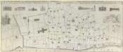
AN EXACT SURVEIGH OF THE STREETS, LANES AND CHURCHES, COMPREHEND.D PLATS, 10 Decem.r A.o Dom.i 1666
1 : 1836 This plan was reduced and engraved by Vertue in 1723 for the Society of Antiquaries. It is a derivative of Leake's 1667 map depicting London after the great fire of the previous year. The title of the map appears at the top, with scale bar at bottom right, a dedication to the Society of Antiquaries at middle left, and the key to lines and symbol in a banner at middle right. Below the title are illustrated prospects of buildings near Temple Gate in Fleet Street, Baynards Castle, St. Paul's Cathedral (from the south and west), Cheapside, Guildhall and the Royal Exchange. A plan of the City of London and Westminster is inset at upper right with a reference table. Vertue, George