Maps of Islington

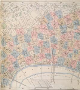
Insurance Plan of London: sheet 6
This detailed 1889 plan of London is one of a series of six sheets in an atlas originally produced to aid insurance companies in assessing fire risks. The building footprints, their use (commercial, residential, educational, etc.), the number of floors and the height of the building, as well as construction materials (and thus risk of burning) and special fire hazards (chemicals, kilns, ovens) were documented in order to estimate premiums. Names of individual businesses, property lines, and addresses were also often recorded. Together these maps provide a rich historical shapshot of the commercial activity and urban landscape of towns and cities at the time. The British Library holds a comprehensive collection of fire insurance plans produced by the London-based firm Charles E. Goad Ltd. dating back to 1885. These plans were made for most important towns and cities of the British Isles at the scales of 1:480 (1 inch to 40 feet), as well as many foreign towns at 1:600 (1 inch to 50 feet). Chas E Goad Limited Chas E Goad Limited
London (1915- Numbered sheets) V.10 (includes: City Of Westminster; Finsbury; Holborn; Inner Temple; Lambeth St Mary; London; Southwark) - 25 Inch Map
1 : 2500 Topographic maps Ordnance Survey Ordnance Survey
LABYRINTHUS LONDINENSIS or THE EQUESTRIAN PERPLEXED
The author of this small plan of London invites his readers to find their way around the city, from the Strand to St. Paul's, avoiding the many roads closed for repair. The plan's title appears at the top, with the royal Arms at the top left, the city arms at the top right, the arms of Bridge House at the bottom right and the arms of Westminster at the bottom left. A note explains the rules of the puzzle in the panel below the plan. Ingrey, Charles
Collins' Illustrated Atlas of London with 7000 references, in 36 plates of the principal routes between St. Paul's and the suburbs, from a survey made expressly for this work, by R. Jarman

Insurance Plan of City of London Vol. II: Key Plan
1 : 480 This "key plan" indicates coverage of the Goad 1886 series of fire insurance maps of London that were originally produced to aid insurance companies in assessing fire risks. The building footprints, their use (commercial, residential, educational, etc.), the number of floors and the height of the building, as well as construction materials (and thus risk of burning) and special fire hazards (chemicals, kilns, ovens) were documented in order to estimate premiums. Names of individual businesses, property lines, and addresses were also often recorded. Together these maps provide a rich historical shapshot of the commercial activity and urban landscape of towns and cities at the time. The British Library holds a comprehensive collection of fire insurance plans produced by the London-based firm Charles E. Goad Ltd. dating back to 1885. These plans were made for most important towns and cities of the British Isles at the scales of 1:480 (1 inch to 40 feet), as well as many foreign towns at 1:600 (1 inch to 50 feet). Chas E Goad Limited Chas E Goad Limited
Legal London
Hoffman, G.
FARRINGDON WARD without WITH ITS Divisions into Parishes taken from the last Survey with Corrections and Amendm.ts 26
1 : 3600 This plan was published in William Maitland's 'History of London from its Foundation to the Present Time'. The plan's title features in cartouche at top left, with the heraldic arms of dedicatee Richard Beckford, the ward Alderman, at top centre. A view of Temple Bar appears at top right, with view of Bridewell North Gate next to the compass star at bottom right. Maitland's ward plans were largely derived from Strype's, with the illustrations copied from West Tow's 1736 'Prospect Views of Ancient Churches'. Farringdon Ward was divided into Farringon Within and Farringdon Without in 1394 because "the governance thereof is too laborious and grievous for one person to occupy and duly govern the same". Cole, B.
Insurance Plan of London Vol. VIII: Key Plan
1 : 480 This "key plan" indicates coverage of the Goad 1888 series of fire insurance maps of London that were originally produced to aid insurance companies in assessing fire risks. The building footprints, their use (commercial, residential, educational, etc.), the number of floors and the height of the building, as well as construction materials (and thus risk of burning) and special fire hazards (chemicals, kilns, ovens) were documented in order to estimate premiums. Names of individual businesses, property lines, and addresses were also often recorded. Together these maps provide a rich historical shapshot of the commercial activity and urban landscape of towns and cities at the time. The British Library holds a comprehensive collection of fire insurance plans produced by the London-based firm Charles E. Goad Ltd. dating back to 1885. These plans were made for most important towns and cities of the British Isles at the scales of 1:480 (1 inch to 40 feet), as well as many foreign towns at 1:600 (1 inch to 50 feet). Chas E Goad Limited Chas E Goad Limited
Plan OF THE PARISHES OR DIVISION OF St Giles in the Fields And ST. GEORGE, BLOOMSBURY. 1815 2
1 : 2400 Different pastel colours describe the Parish divisions within St. Giles in the Fields and St. George's, Bloomsbury. A plan of the Burial Ground and Chapel of St. Giles in the Field, adjoining the church yard of St Pancreas, is located in a separate border. Montagu House was sold in 1755 to house the British museum. It was demolished to make way for Smirke''s building in the 1840''s. Hewitt, N.R.
To the Most Noble JOHN, DUKE OF BEDFORD. This Plan of the United Parishes of ST. GILES in the FIELDS & ST. GEORGE, BLOOMSBURY, 4
1 : 444 This map is dedicated to the Duke of Bedford as this area was the primary metropolitan estate of the Earls ans Dukes of Bedford. Russell was the family name of the Dukes of Bedford, hence Russell Square. Bedford house, built for the 3rd Earl of Bedford in 1586, lay adjacent to Montague house, later to be the British Museum, until 1705-6 when it was demolished. In the lower left hand corner is a vignette of a statue of a Duke of Bedford. A birds eye view of the British Museum and a view of the College of Surgeons are also included as is a statue of C.J Fox right hon, the orator. Wyld, James
A Mapp of ST. ANDREWS HOLBORN Parish As well within the Liberty as without. Taken from the last Survey, with Corrections and Enlargements. Part A0
1 : 3600 Plan of the Parish of St Andrew's, Holborn from the 1720 edition of Stow's survey of England. The plan features title in ornamental cartouche at top right and reference table down the left side of the plate. Lincolns Inn, one of the four Inns of Court, is shown in elevation. A pecked line encloses the parish. Blome, Richard
FARRINGDON WARD without WITH ITS Divisions into Parishes taken from the last Survey with Corrections and Amendm.ts 24A
1 : 3600 This plan was published in Strype's first annotated edition of Stow's 'Survey of England'. The plan's title features in banner at the top of the plate, with a compass star at middle left. The key to streets, yards, halls, courts and private properties appears in a table at lower right, with the wards prominent buildings shown pictorially. Farringdon ward was divided into Farringon Within and Farringdon Without in 1394 because "the governance thereof is too laborious and grievous for one person to occupy and duly govern the same". Blome, Richard
Insurance Plan of London Vol. VI: Key Plan 1
1 : 480 This "key plan" indicates coverage of the Goad 1887 series of fire insurance maps of London that were originally produced to aid insurance companies in assessing fire risks. The building footprints, their use (commercial, residential, educational, etc.), the number of floors and the height of the building, as well as construction materials (and thus risk of burning) and special fire hazards (chemicals, kilns, ovens) were documented in order to estimate premiums. Names of individual businesses, property lines, and addresses were also often recorded. Together these maps provide a rich historical shapshot of the commercial activity and urban landscape of towns and cities at the time. The British Library holds a comprehensive collection of fire insurance plans produced by the London-based firm Charles E. Goad Ltd. dating back to 1885. These plans were made for most important towns and cities of the British Isles at the scales of 1:480 (1 inch to 40 feet), as well as many foreign towns at 1:600 (1 inch to 50 feet). Chas E Goad Limited Chas E Goad Limited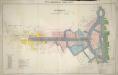
Plan of Kingsway, From Report of the Royal Commission on cross-river traffic in London, Plate XVIII

A Mapp of the Parishes of {ST.CLEMENTS DANES, ST. MARY SAVOY; with the Rolls Liberty and Lincolns Inn. taken From the last Survey with Corrections and Additions 50
1 : 2616 This is the second edition of Blome's map. His name was removed from the cartouche because Strype had taken over as editor of the project. The map shows in elevation the Savoy, Somerset House and gardens, Exeter Exchange and temple, and Lincoln's Inn. The church, St Mary-le-Strand, opposite Somerset House was absent from the earlier edition. It is shown here in plan, but is unnamed and not referred to in the numerical key. Blome, Richard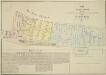
MAP OF THE Manor of the Savoy AND OF THE LIBERTY OF THE DUCHY OF LANCASTER CALLED The Savoy Liberty, In the County of Middlesex. 1830
1 : 1128 The Savoy Liberty is divided into four wards which are delineated by different pastle shades, an explanation of which appears in the table. St Mary-le-Strand and the Site of the Lyceum Theatre, now in ruins, are shown, as is the ancient site of Burliegh House. Madeley, G. E.
BAYNARDS CASTLE AND FARINGDON WARD WITHIN with their Divisions into Parishes according to a new SURVEY.
1 : 3600 This plan was published in William Maitland's 'History of London from its Foundation to the Present Time'. Its title features in cartouche at lower left, with the arms of Sir Robert Ladbrook, Alderman of Baynord Castle, and William Bridgen, Alderman of Farringdon Within, at bottom left. The compass star appears at bottom centre. An illustrated view of St Bennet's Church is at top left, with St Martin's Church at top right and St. Andrew's church at bottom right. Maitland's ward plans were largely derived from Strype's plans, with the illustrations copied from West Tow's 1736 'Prospect Views of Ancient Churches'. Farringdon Ward was divided into Farringon Within and Farringdon Without in 1394 because "the governance thereof is too laborious and grievous for one person to occupy and duly govern the same." Cole, B.
FARINGTON within and BAYNARD CASTLE with its Divisions into Parishes taken from the last Survey with Corrections. 23A
1 : 2400 This plan was published in Strype's first annotated edition of Stow's 'Survey of England'. The plan's title features in cartouche at top left, with compass star and scale bar near bottom left. The keys to streets, yards, halls, courts and private properties appear in tables down both sides of the plate. St. Paul's Cathedral and other prominent buildings are shown pictorially. Farringdon Ward was divided into Farringon Within and Farringdon Without in 1394 because "the governance thereof is too laborious and grievous for one person to occupy and duly govern the same". Blome, Richard
London VII.54 - OS London Town Plan
1 : 1056 Topographic maps Ordnance Survey Ordnance Survey
London VII.64 - OS London Town Plan
1 : 1056 Topographic maps Ordnance Survey Ordnance Survey
London VII.74 - OS London Town Plan
1 : 1056 Topographic maps Ordnance Survey Ordnance Survey
Insurance Plan of City of London Vol. I: Key Plan
1 : 480 This "key plan" indicates coverage of the Goad 1886 series of fire insurance maps of London that were originally produced to aid insurance companies in assessing fire risks. The building footprints, their use (commercial, residential, educational, etc.), the number of floors and the height of the building, as well as construction materials (and thus risk of burning) and special fire hazards (chemicals, kilns, ovens) were documented in order to estimate premiums. Names of individual businesses, property lines, and addresses were also often recorded. Together these maps provide a rich historical shapshot of the commercial activity and urban landscape of towns and cities at the time. The British Library holds a comprehensive collection of fire insurance plans produced by the London-based firm Charles E. Goad Ltd. dating back to 1885. These plans were made for most important towns and cities of the British Isles at the scales of 1:480 (1 inch to 40 feet), as well as many foreign towns at 1:600 (1 inch to 50 feet). Chas E Goad Limited Chas E Goad Limited
London VII.75 - OS London Town Plan
1 : 1056 Topographic maps Ordnance Survey Ordnance Survey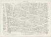
London VII.65 - OS London Town Plan
1 : 1056 Topographic maps Ordnance Survey Ordnance Survey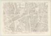
London VII.55 - OS London Town Plan
1 : 1056 Topographic maps Ordnance Survey Ordnance Survey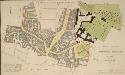
PLAN of the PARISH of ST. SEPULCHRE, MIDDLESEX
1 : 792 The title of this plan of a parish in Finsbury appears with the publisher's imprint and scale bars, at bottom right. The compass star is at top left. Parish boundaries are outlined in red. A note at bottom left reports the results of the census of 1821. In that year the parish had 574 houses and a population of 4740. Gardner, B. H.
CASTLE-BAYNARD WARD A New Survey 1794.
1 : 1800 This is a 19th-Century tracing of an original 1794 plan of the Castle Baynard ward in the City of London. The plan's title features at top left below the city arms, with scale bar at bottom centre. It also shows the ground plan of St. Paul's Cathedral and Newgate market.
Drawn Plan of the Property of St. Barholomew's Hospital from Christ's Hospital to Smithfield
This is an 18th Century copy of Ralph Treswell's 1610 plan of the property of St. Bartholomew's Hospital. Although better known as a painter in his lifetime, Treswell was also a mapmaker and one of the first surveyors of the modern era. The plan features compass star and scale bar at top right, showing the Roman wall, Christ's Hospital and the properties along the way to St. Bartholomew's Hospital pictorially.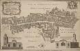
ALDERSGATE WARD with its DIVISIONS into Precincts and Parishes And the Liberty of St. Martins le Grand, according to a NEW SURVEY
1 : 2400 This plan was published in William Maitlan's 'History of London from its Foundation to the Present Time'. The plan's title features in cartouche at top left, with the arms of the Alderman William Benn, to whom the plan is dedicated, at top right. A view of St Anne Agnes' Church is included at bottom left, with compass star and scale bar at bottom centre, and a view of St Botolph's church at bottom right. Maitland's ward plans were largely derived from Strype's plans, with the illustrations copied from West Tow's 1736 'Prospect Views of Ancient Churches'. Cole, B.