Maps of Islington

Insurance Plan of City of London Vol. I: sheet 6
1 : 480 This detailed 1886 plan of London is one of a series of twenty-five sheets in an atlas originally produced to aid insurance companies in assessing fire risks. The building footprints, their use (commercial, residential, educational, etc.), the number of floors and the height of the building, as well as construction materials (and thus risk of burning) and special fire hazards (chemicals, kilns, ovens) were documented in order to estimate premiums. Names of individual businesses, property lines, and addresses were also often recorded. Together these maps provide a rich historical shapshot of the commercial activity and urban landscape of towns and cities at the time. The British Library holds a comprehensive collection of fire insurance plans produced by the London-based firm Charles E. Goad Ltd. dating back to 1885. These plans were made for most important towns and cities of the British Isles at the scales of 1:480 (1 inch to 40 feet), as well as many foreign towns at 1:600 (1 inch to 50 feet). Chas E Goad Limited Chas E Goad Limited
Insurance Plan of London Vol. 1: sheet 6
1 : 480 This detailed 1904 plan of London is one of a series of twenty-five sheets in an atlas originally produced to aid insurance companies in assessing fire risks. The building footprints, their use (commercial, residential, educational, etc.), the number of floors and the height of the building, as well as construction materials (and thus risk of burning) and special fire hazards (chemicals, kilns, ovens) were documented in order to estimate premiums. Names of individual businesses, property lines, and addresses were also often recorded. Together these maps provide a rich historical shapshot of the commercial activity and urban landscape of towns and cities at the time. The British Library holds a comprehensive collection of fire insurance plans produced by the London-based firm Charles E. Goad Ltd. dating back to 1885. These plans were made for most important towns and cities of the British Isles at the scales of 1:480 (1 inch to 40 feet), as well as many foreign towns at 1:600 (1 inch to 50 feet). Chas E Goad Limited Chas E Goad Limited
Insurance Plan of London Vol. 1: sheet 13
1 : 360 This detailed 1904 plan of London is one of a series of twenty-five sheets in an atlas originally produced to aid insurance companies in assessing fire risks. The building footprints, their use (commercial, residential, educational, etc.), the number of floors and the height of the building, as well as construction materials (and thus risk of burning) and special fire hazards (chemicals, kilns, ovens) were documented in order to estimate premiums. Names of individual businesses, property lines, and addresses were also often recorded. Together these maps provide a rich historical shapshot of the commercial activity and urban landscape of towns and cities at the time. The British Library holds a comprehensive collection of fire insurance plans produced by the London-based firm Charles E. Goad Ltd. dating back to 1885. These plans were made for most important towns and cities of the British Isles at the scales of 1:480 (1 inch to 40 feet), as well as many foreign towns at 1:600 (1 inch to 50 feet). Chas E Goad Limited Chas E Goad Limited
WALBROOK WARD AND DOWGATE WARD with their Divisions into Parishes according to a New SURVEY.
1 : 2040 This plan was published in William Maitland's 'History of London from its Foundation to the Present Day'. The title features in cartouche at bottom centre, next to the arms of ward alderman Richard Glynn and the Lord Mayor of London Hingsby Bethall. Thecompass star appears at top centre with views of the parish churches of St Stephen and St Michael down the right side of the plate. Maitland's ward plans were largely derived from Strype's, with the illustrations copied from West Tow's 1736 Prospect Views of Ancient Churches'. Cole, B.
WALBROOK WARD and DOWGATE WARD with its Division into Parishes taken from the last Survey 40A
1 : 2040 This plan was published in Strype's first annotated edition of Stowe's 'Survey of England'. Its title features in cartouche at top centre, with compass star at bottom left and scale bar at bottom right. A key to streets, churches and halls appears in a panel down the right side of the plate. Blome, Richard
QUEEN-HITH WARD AND VINTRY WARD with their Divisions into PARISHES according to a new SURVEY.
1 : 2760 This plan was published in Maitland's 'History of London from its Foundations to the Present Day'. The title features in cartouche at the foot of the pate, together with the arms of Sir Crisp Gascoyne, Alderman of Vintry Ward, and Martin Dickinson, Alderman of Queenhithe Ward. The scale bar and compass star feature near top left, facing an illustrated view of the parish church of St. Michael at bottom left. Maitland's ward plans were largely derived from Strype's plans, with the illustrations copied from West & Tow's 'Prospect Views of Ancient Churches' of 1736. Cole, B.
QUEEN HITH Ward and VINTRY Ward with their Divisions into Parishes taken from the last Survey. 35A
1 : 1920 This plan was published in Strype's 1720 annotated edition of Stow's 'Survey of England'. It's title features in cartouche at the top centre, with scale bar down the right side of the plate and a compass star near bottom right. Keys to streets, yards, halls and churches appear in panels at middle left and top right. Blome, Richard
An Exact and Correct PLAN of CORDWAINERS WARD Taken by Order of S.r HENRY BANKES Kn.t And ALDERMAN 1768.
1 : 408 The title of this plan appears;at the top, together with the arms of Sir Henry Bankes, the ward alderman who commissioned the plan. Also featured is a list of elected ward members sitting in the Court of Common Council, one of the two governing bodies of the City of London. A key to alleys, yards and courts appears to the right of the plan.
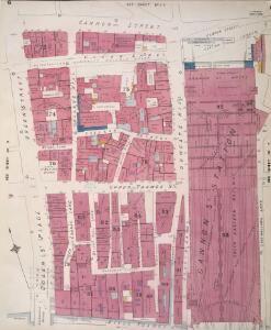
Insurance Plan of City of London Vol. I: sheet 13
1 : 480 This detailed 1886 plan of London is one of a series of twenty-five sheets in an atlas originally produced to aid insurance companies in assessing fire risks. The building footprints, their use (commercial, residential, educational, etc.), the number of floors and the height of the building, as well as construction materials (and thus risk of burning) and special fire hazards (chemicals, kilns, ovens) were documented in order to estimate premiums. Names of individual businesses, property lines, and addresses were also often recorded. Together these maps provide a rich historical shapshot of the commercial activity and urban landscape of towns and cities at the time. The British Library holds a comprehensive collection of fire insurance plans produced by the London-based firm Charles E. Goad Ltd. dating back to 1885. These plans were made for most important towns and cities of the British Isles at the scales of 1:480 (1 inch to 40 feet), as well as many foreign towns at 1:600 (1 inch to 50 feet). Chas E Goad Limited Chas E Goad Limited
BREADSTREET Ward and CORDWAINER WARD with the Divisions into Parishes taken from the last Survey. 10A
1 : 1680 This plan was published in Strype's first annotated edition of Stow's 'Survey of England'. The plan's title features in cartouche at the top centre, with compass star at bottom left and the keys to streets, yards, halls, courts and private properties in tables at bottom right. Blome, Richard
Insurance Plan of London Vol. 1: sheet 5
1 : 480 This detailed 1904 plan of London is one of a series of twenty-five sheets in an atlas originally produced to aid insurance companies in assessing fire risks. The building footprints, their use (commercial, residential, educational, etc.), the number of floors and the height of the building, as well as construction materials (and thus risk of burning) and special fire hazards (chemicals, kilns, ovens) were documented in order to estimate premiums. Names of individual businesses, property lines, and addresses were also often recorded. Together these maps provide a rich historical shapshot of the commercial activity and urban landscape of towns and cities at the time. The British Library holds a comprehensive collection of fire insurance plans produced by the London-based firm Charles E. Goad Ltd. dating back to 1885. These plans were made for most important towns and cities of the British Isles at the scales of 1:480 (1 inch to 40 feet), as well as many foreign towns at 1:600 (1 inch to 50 feet). Chas E Goad Limited Chas E Goad Limited
Insurance Plan of City of London Vol. I: sheet 5
1 : 480 This detailed 1886 plan of London is one of a series of twenty-five sheets in an atlas originally produced to aid insurance companies in assessing fire risks. The building footprints, their use (commercial, residential, educational, etc.), the number of floors and the height of the building, as well as construction materials (and thus risk of burning) and special fire hazards (chemicals, kilns, ovens) were documented in order to estimate premiums. Names of individual businesses, property lines, and addresses were also often recorded. Together these maps provide a rich historical shapshot of the commercial activity and urban landscape of towns and cities at the time. The British Library holds a comprehensive collection of fire insurance plans produced by the London-based firm Charles E. Goad Ltd. dating back to 1885. These plans were made for most important towns and cities of the British Isles at the scales of 1:480 (1 inch to 40 feet), as well as many foreign towns at 1:600 (1 inch to 50 feet). Chas E Goad Limited Chas E Goad Limited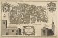
BREADSTREET WARD AND CORDWAINER WARD with their Divisions into Parishes According to a new SURVEY.
1 : 1800 This plan was published in William Maitland's 'History of London from its Foundation to the Present Time'. The plan's title features in cartouche at the foot of the plate with the family arms of the dedicatees Stephen Theodor Janssen (Alderman of Cordwainer ward and Lord Mayor of London) and William Alexander (Alderman of Breadstreet ward) at top left and right, respectively. Views of St Matthew and St. Mildred's parish churches are at bottom left and bottom right. Maitland's ward plans were largely derived from Strype's plans, with the illustrations copied from West & Tow's 'Prospect Views of Ancient Churches' of 1736. Cole, B.
Insurance Plan of London Vol. 1: sheet 7
1 : 480 This detailed 1904 plan of London is one of a series of twenty-five sheets in an atlas originally produced to aid insurance companies in assessing fire risks. The building footprints, their use (commercial, residential, educational, etc.), the number of floors and the height of the building, as well as construction materials (and thus risk of burning) and special fire hazards (chemicals, kilns, ovens) were documented in order to estimate premiums. Names of individual businesses, property lines, and addresses were also often recorded. Together these maps provide a rich historical shapshot of the commercial activity and urban landscape of towns and cities at the time. The British Library holds a comprehensive collection of fire insurance plans produced by the London-based firm Charles E. Goad Ltd. dating back to 1885. These plans were made for most important towns and cities of the British Isles at the scales of 1:480 (1 inch to 40 feet), as well as many foreign towns at 1:600 (1 inch to 50 feet). Chas E Goad Limited Chas E Goad Limited
Insurance Plan of City of London Vol. I: sheet 12
1 : 480 This detailed 1886 plan of London is one of a series of twenty-five sheets in an atlas originally produced to aid insurance companies in assessing fire risks. The building footprints, their use (commercial, residential, educational, etc.), the number of floors and the height of the building, as well as construction materials (and thus risk of burning) and special fire hazards (chemicals, kilns, ovens) were documented in order to estimate premiums. Names of individual businesses, property lines, and addresses were also often recorded. Together these maps provide a rich historical shapshot of the commercial activity and urban landscape of towns and cities at the time. The British Library holds a comprehensive collection of fire insurance plans produced by the London-based firm Charles E. Goad Ltd. dating back to 1885. These plans were made for most important towns and cities of the British Isles at the scales of 1:480 (1 inch to 40 feet), as well as many foreign towns at 1:600 (1 inch to 50 feet). Chas E Goad Limited Chas E Goad Limited
Insurance Plan of City of London Vol. I: sheet 14
1 : 480 This detailed 1886 plan of London is one of a series of twenty-five sheets in an atlas originally produced to aid insurance companies in assessing fire risks. The building footprints, their use (commercial, residential, educational, etc.), the number of floors and the height of the building, as well as construction materials (and thus risk of burning) and special fire hazards (chemicals, kilns, ovens) were documented in order to estimate premiums. Names of individual businesses, property lines, and addresses were also often recorded. Together these maps provide a rich historical shapshot of the commercial activity and urban landscape of towns and cities at the time. The British Library holds a comprehensive collection of fire insurance plans produced by the London-based firm Charles E. Goad Ltd. dating back to 1885. These plans were made for most important towns and cities of the British Isles at the scales of 1:480 (1 inch to 40 feet), as well as many foreign towns at 1:600 (1 inch to 50 feet). Chas E Goad Limited Chas E Goad Limited
Insurance Plan of City of London Vol. I: sheet 7
1 : 480 This detailed 1886 plan of London is one of a series of twenty-five sheets in an atlas originally produced to aid insurance companies in assessing fire risks. The building footprints, their use (commercial, residential, educational, etc.), the number of floors and the height of the building, as well as construction materials (and thus risk of burning) and special fire hazards (chemicals, kilns, ovens) were documented in order to estimate premiums. Names of individual businesses, property lines, and addresses were also often recorded. Together these maps provide a rich historical shapshot of the commercial activity and urban landscape of towns and cities at the time. The British Library holds a comprehensive collection of fire insurance plans produced by the London-based firm Charles E. Goad Ltd. dating back to 1885. These plans were made for most important towns and cities of the British Isles at the scales of 1:480 (1 inch to 40 feet), as well as many foreign towns at 1:600 (1 inch to 50 feet). Chas E Goad Limited Chas E Goad Limited
Insurance Plan of London Vol. 1: sheet 14
1 : 480 This detailed 1904 plan of London is one of a series of twenty-five sheets in an atlas originally produced to aid insurance companies in assessing fire risks. The building footprints, their use (commercial, residential, educational, etc.), the number of floors and the height of the building, as well as construction materials (and thus risk of burning) and special fire hazards (chemicals, kilns, ovens) were documented in order to estimate premiums. Names of individual businesses, property lines, and addresses were also often recorded. Together these maps provide a rich historical shapshot of the commercial activity and urban landscape of towns and cities at the time. The British Library holds a comprehensive collection of fire insurance plans produced by the London-based firm Charles E. Goad Ltd. dating back to 1885. These plans were made for most important towns and cities of the British Isles at the scales of 1:480 (1 inch to 40 feet), as well as many foreign towns at 1:600 (1 inch to 50 feet). Chas E Goad Limited Chas E Goad Limited
Insurance Plan of London Vol. 1: sheet 12
1 : 360 This detailed 1904 plan of London is one of a series of twenty-five sheets in an atlas originally produced to aid insurance companies in assessing fire risks. The building footprints, their use (commercial, residential, educational, etc.), the number of floors and the height of the building, as well as construction materials (and thus risk of burning) and special fire hazards (chemicals, kilns, ovens) were documented in order to estimate premiums. Names of individual businesses, property lines, and addresses were also often recorded. Together these maps provide a rich historical shapshot of the commercial activity and urban landscape of towns and cities at the time. The British Library holds a comprehensive collection of fire insurance plans produced by the London-based firm Charles E. Goad Ltd. dating back to 1885. These plans were made for most important towns and cities of the British Isles at the scales of 1:480 (1 inch to 40 feet), as well as many foreign towns at 1:600 (1 inch to 50 feet). Chas E Goad Limited Chas E Goad Limited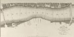
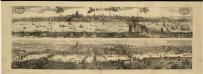
A SURVEY of the RIVER THAMES between London Bridge and Blackfriars Bridge with the SOUNDINGS within those Limits
1 : 2664 The title of this plan appears at bottom right, with compass star and scale bar at bottom centre. Produced by the Surveying Office at Guildhall, the plan was intended as an aid for navigation along the Thames and indicates the location of all stairs to the river and water soundings at various points along the course. Surveying Office, Guildhall
Insurance Plan of City of London Vol. I: Key Plan
1 : 480 This "key plan" indicates coverage of the Goad 1886 series of fire insurance maps of London that were originally produced to aid insurance companies in assessing fire risks. The building footprints, their use (commercial, residential, educational, etc.), the number of floors and the height of the building, as well as construction materials (and thus risk of burning) and special fire hazards (chemicals, kilns, ovens) were documented in order to estimate premiums. Names of individual businesses, property lines, and addresses were also often recorded. Together these maps provide a rich historical shapshot of the commercial activity and urban landscape of towns and cities at the time. The British Library holds a comprehensive collection of fire insurance plans produced by the London-based firm Charles E. Goad Ltd. dating back to 1885. These plans were made for most important towns and cities of the British Isles at the scales of 1:480 (1 inch to 40 feet), as well as many foreign towns at 1:600 (1 inch to 50 feet). Chas E Goad Limited Chas E Goad Limited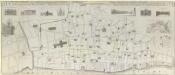
AN EXACT SURVEIGH OF THE STREETS, LANES AND CHURCHES, COMPREHEND.D PLATS, 10 Decem.r A.o Dom.i 1666
1 : 1836 This plan was reduced and engraved by Vertue in 1723 for the Society of Antiquaries. It is a derivative of Leake's 1667 map depicting London after the great fire of the previous year. The title of the map appears at the top, with scale bar at bottom right, a dedication to the Society of Antiquaries at middle left, and the key to lines and symbol in a banner at middle right. Below the title are illustrated prospects of buildings near Temple Gate in Fleet Street, Baynards Castle, St. Paul's Cathedral (from the south and west), Cheapside, Guildhall and the Royal Exchange. A plan of the City of London and Westminster is inset at upper right with a reference table. Vertue, George
Insurance Plan of London Vol. 1: Key Plan
1 : 3600 This "key plan" indicates coverage of the Goad 1904 series of fire insurance maps of London that were originally produced to aid insurance companies in assessing fire risks. The building footprints, their use (commercial, residential, educational, etc.), the number of floors and the height of the building, as well as construction materials (and thus risk of burning) and special fire hazards (chemicals, kilns, ovens) were documented in order to estimate premiums. Names of individual businesses, property lines, and addresses were also often recorded. Together these maps provide a rich historical shapshot of the commercial activity and urban landscape of towns and cities at the time. The British Library holds a comprehensive collection of fire insurance plans produced by the London-based firm Charles E. Goad Ltd. dating back to 1885. These plans were made for most important towns and cities of the British Isles at the scales of 1:480 (1 inch to 40 feet), as well as many foreign towns at 1:600 (1 inch to 50 feet). Chas E Goad Limited Chas E Goad Limited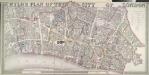
WYLD'S PLAN OF THE CITY OF LONDON
This map of the City of London is based on Horwood's map of 1792-9. The map is enclosed in a border and features title inset in the top border, scale bar and imprint in the bottom border and table with reference to City wards at top right. Ward boundaries are highlighted in colour. Wyld, James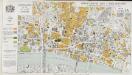
Report of the Improvements and Town Planning Committee to the Right Honourable the Lord Mayor, Aldermen and Commons of the City of London, in Common Council assembled on the preliminary draft proposals for post-war reconstruction in the City of London.
Corporation of London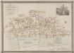
GENERAL PLAN OF THAT PART OF THE CITY OF LONDON THAT WAS DESTROYED BY THE GREAT FIRE OF 1666; SHOWING THE PRESENT STATE THEREOF
1 : 2431 This retrospective map compares pre-fire London with the city of the 1830s. The title and publisher's imprint appear at top left, with a reference table at bottom right, scale bar at bottom centre, and woodcut view of the Temple at top right. The map shows churches, halls and public buildings destroyed in the fire in grey,with contemporary buildings in pink. Wishaw, Francis
Greater London Plan 1944. By Patrick Abercrombie
Abercrombie, Patrick His Majesty's Stationery Office
PLAN OF THE CITY OF LONDON DIVIDED INTO WARDS
This plan was published in Allen's 'History of London' of 1828. Its title and a list of the city wards feature below the plan, with ward boundaries indicated by a dotted line. City wards were created in the Norman era with aldermen elected for life for the purpose of government. Ward 'beadles' were employed fulltime with responsibility for the "preservation of peace, supervision of trading, sanitation and local upkeep". Allen, Thomas
General Plan of the City of London
Haywood, William London