Maps of Camden

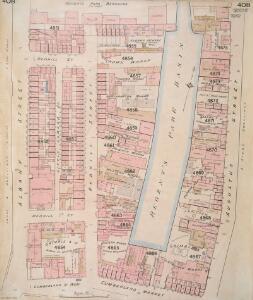
Insurance Plan of London Vol. xi: sheet 408
1 : 480 This detailed 1891 plan of London is one of a series of forty seven sheets in an atlas originally produced to aid insurance companies in assessing fire risks. The building footprints, their use (commercial, residential, educational, etc.), the number of floors and the height of the building, as well as construction materials (and thus risk of burning) and special fire hazards (chemicals, kilns, ovens) were documented in order to estimate premiums. Names of individual businesses, property lines, and addresses were also often recorded. Together these maps provide a rich historical shapshot of the commercial activity and urban landscape of towns and cities at the time. The British Library holds a comprehensive collection of fire insurance plans produced by the London-based firm Charles E. Goad Ltd. dating back to 1885. These plans were made for most important towns and cities of the British Isles at the scales of 1:480 (1 inch to 40 feet), as well as many foreign towns at 1:600 (1 inch to 50 feet). Chas E Goad Limited Chas E Goad Limited
London VII.32 - OS London Town Plan
1 : 1056 Topographic maps Ordnance Survey Ordnance Survey
Insurance Plan of London North West District Vol. C: Index Key Plan A
1 : 480 This "key plan" indicates coverage of the Goad 1900 series of fire insurance maps of London that were originally produced to aid insurance companies in assessing fire risks. The building footprints, their use (commercial, residential, educational, etc.), the number of floors and the height of the building, as well as construction materials (and thus risk of burning) and special fire hazards (chemicals, kilns, ovens) were documented in order to estimate premiums. Names of individual businesses, property lines, and addresses were also often recorded. Together these maps provide a rich historical shapshot of the commercial activity and urban landscape of towns and cities at the time. The British Library holds a comprehensive collection of fire insurance plans produced by the London-based firm Charles E. Goad Ltd. dating back to 1885. These plans were made for most important towns and cities of the British Isles at the scales of 1:480 (1 inch to 40 feet), as well as many foreign towns at 1:600 (1 inch to 50 feet). Chas E Goad Limited Chas E Goad Limited
London (1915- Numbered sheets) V.5 (includes: St Marylebone; St Pancras) - 25 Inch Map
1 : 2500 Topographic maps Ordnance Survey Ordnance Survey
London (First Editions c1850s) XXV (includes: St Marylebone; St Pancras) - 25 Inch Map
1 : 2500 Topographic maps Ordnance Survey Ordnance Survey
Insurance Plan of London Vol. xi: sheet 372-2
1 : 480 This detailed 1891 plan of London is one of a series of forty seven sheets in an atlas originally produced to aid insurance companies in assessing fire risks. The building footprints, their use (commercial, residential, educational, etc.), the number of floors and the height of the building, as well as construction materials (and thus risk of burning) and special fire hazards (chemicals, kilns, ovens) were documented in order to estimate premiums. Names of individual businesses, property lines, and addresses were also often recorded. Together these maps provide a rich historical shapshot of the commercial activity and urban landscape of towns and cities at the time. The British Library holds a comprehensive collection of fire insurance plans produced by the London-based firm Charles E. Goad Ltd. dating back to 1885. These plans were made for most important towns and cities of the British Isles at the scales of 1:480 (1 inch to 40 feet), as well as many foreign towns at 1:600 (1 inch to 50 feet). Chas E Goad Limited Chas E Goad Limited
Some account of the proposed improvements of the Western part of London, by the formation of the Regent's Park, the new street, the new sewer. ... Illustrated by plans and accompanied by critical observations.

THE REGENT'S PARK
1 : 4800 This plan was commissioned by the House of Commons and issued as a supplement to the Wood, Forests and Land Revenues report. The plan's title and imprint are at top right, with a scale bar and key at bottom right. The part of the park to be opened to the public is shown in pale yellow. The grounds of the Zoological Society and the Royal Botanic Society are shown in pink. The areas to be fenced off to protect the privacy of the local residents are shown in dark green. The land to the north of the park recently acquired by Eton College is shown in pale green, and that acquired by Lord Southampton, in pink. Basire, James
London VII.NW - OS Six-Inch Map
1 : 10560 Topographic maps Ordnance Survey Ordnance Survey
PLAN of the several Freehold Estates situated on the North side of the New Road within the Parish of St. Mary-le-bone and Parts of Hampstead and St. Pancras in the County of Middlesex
1 : 1584 This is Crace's own copy of an 18th-Century plan of the estates north of the New Road at Marylebone. The title and scale bar feature at bottom left, with compass at top centre, and descriptive notes at top left and down the right margin of the sheet. Outline colour marks the boundaries of estates and a single black line those of fields within the estate. The plan also reports the names of landlords and tenant occupiers, with key to the dimensions of each field and estate in a table above the plan. Jones, John
A Plan of the New Intended Road from Paddington to Islington.

A Plan of te Parish of ST MARY ISLINGTON, with the boundaries of the Several Ecclesiastical Districts, Sueveyed by R. Creighton for the Parochial History, BY S. LEWIS, JUNR.
1 : 15840 Plan of the parish of St Mary's Islington, with the nine ecclesiastical districts that make up the parish delineated by pastel colours. Dower, John, Pentonville.
Charles Booth's descriptive map of London poverty 1889
Charles Booth
PLAN OF THE PARISH OF ST. MARYLEBONE with the Improvements proposed ON THE MARYLEBONE PARK ESTATE WITH THE CONTIGUOUS PARTS of the Parish of St. Pancras
1 : 5333 Plan of the Parish of St. Marylebone with title at bottom left and explanatory note at bottom right describing proposals for building houses and gardens on land belonging to the Crown along the New Road. White, John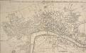
A New and Accurate PLAN of the CITIES of LONDON AND WESTMINSTER, including the NEW ROADS & NEW BUILDINGS. 1765
This map shows the London, Westminster and Blackfriars bridges across the Thames, marking the many stairways down to the water necessary before the bridges were built.
WALLIS'S PLAN of the CITIES of LONDON and WESTMINSTER 1797
This is the first edition of a map published seven times over a period of 16 years. This plan has been physically trimmed resulting in the loss of some information. The scale bar and list of Hackney coach fares would have been to the bottom right. Wallis, John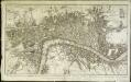
Plan nouveau et correct des villes et fauxbourgs de Londres et Westminster et du bourg de Southwark
1 Plan : Kupferdruck ; 28 x 48 cm Le Rouge Georges Louis le Rouge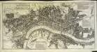
A pocket map of London, Westminster and Southwark
1 Plan : Kupferdruck ; 26 x 51 cm Hoole; Seale printed and sold by H. Overton and J. Hoole at the White Horse without Newgate
Insurance Plan of London North District Vol. D: Key Plan
1 : 3600 This "key plan" indicates coverage of the Goad 1901 series of fire insurance maps of London that were originally produced to aid insurance companies in assessing fire risks. The building footprints, their use (commercial, residential, educational, etc.), the number of floors and the height of the building, as well as construction materials (and thus risk of burning) and special fire hazards (chemicals, kilns, ovens) were documented in order to estimate premiums. Names of individual businesses, property lines, and addresses were also often recorded. Together these maps provide a rich historical shapshot of the commercial activity and urban landscape of towns and cities at the time. The British Library holds a comprehensive collection of fire insurance plans produced by the London-based firm Charles E. Goad Ltd. dating back to 1885. These plans were made for most important towns and cities of the British Isles at the scales of 1:480 (1 inch to 40 feet), as well as many foreign towns at 1:600 (1 inch to 50 feet). Chas E Goad Limited Chas E Goad Limited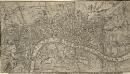
A Correct PLAN of the CITIES of LONDON & WESTMINSTER & BOROUGH of SOUTHWARK, including the BILLS of MORTALITY, with the ADDITIONAL BUILDINGS 118x
This map of London was published as a supplement to Vol. 30 of the 'London Magazine' in 1761. Attributed to John Rocque, the map’s title features in panel below the plan with the publisher’s imprint along the top. The Bills of Mortality referred to in the title were the areas in Greater London that reported death notices directly to the London government. Rocque, John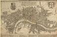
A POCKET MAP OF LONDON, WESTMINSTER AND SOUTHWARK With ye New Buildings to ye Year 1739
The map's title appears in English and Dutch in a panel along the top. A descriptive note features below the title, with royal arms at top left, city arms at top right and fares of hackney coaches and water ferries in a panel below the plan. The map shows the new bridge at Westminster and represents prominent buildings and landmark three-dimensionally. De Leth, Hendrick
A Correct PLAN of the CITIES of LONDON & WESTMINSTER & BOROUGH of SOUTHWARK, including the BILLS of MORTALITY, with the ADDITIONAL BUILDINGS 118
This map of London was published as supplement to Volume 30 of the 'London Magazine' in 1761. Attributed to John Rocque, the map's title features in a panel below the plan, with the publisher’s imprint along the top. [Rocque, John]
A New PLAN of LONDON WESTMINSTER and SOUTHWARK Engraved for Noorthouck's
This map highlights in red the boundaries of the old London Wall, built by the Romans. By the end of the 17th Century it had become an anachronistic nuisance. The first section (near Bishops Gate) was removed in 1707 and much of the rest was broken down or built over during the 18th Century. Most of the gates were pulled down in 1760/1, wtih Newgate, the last to survive, demolished in 1777. Noorthouck, John
PLATTE GRONDT DER STADT LONDON MET AENWYSINGHE HOE DIE AFGEBRANDT
This map was published in Amsterdam after the great fire of 1666. The title appears along the top of the manuscript, with the key to parish churches (in scrolls) at top left and top right, and dividers at top right. An engraving of the great fire is inset at bottom right, entitled "BRANDENT LONDON". Below the plan, the fire is described in Dutch and French. Wit, Frederick de
A new mapp of the city of London &c. : with the many additionall buildings and new streets anno 1723 in a playne
1 : 7300 Taylor, Thomas, fl. 1670-1730 Printed and sold by Thomas Taylor at the Golden Lyon in Fleet Street
London NW.
1 : 15840 Stanford, Edward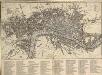
An IMPROVED PLAN of the CITIES of LONDON and WESTMINSTER and BOROUGH of SOUTHWARK, including the NEW BUILDINGS, ROADS &C. to the Present Year 1765.
The title of this pocket map appears along the top, with built-up areas represented by stippling in the City of London, and crosshatching elsewhere. A table of reference appears in a panel below the plan. The map, a later edition of Kitching and Parker's 1765 plan, shows the new bridge and the approaches at Blackfriars. Designed by Robert Mylne, this third bridge spanning the Thames was built between 1760 and 69. The nine semi-elliptical Portland stone arches were replaced from 1860 to 69 by the present structure of five wrought-iron arches each faced with cast iron, and a granite pier designed by Cubitt and Carr. Kitching, Thomas and Parker, Henry
A NEW and Correct PLAN OF THE CITIES AND SUBURBS OF LONDON & WESTMINSTER & BOROUGH OF SOUTHWARK with the COUNTRY adjacent, the NEW BUILDINGS, ROADS &c. to the Year 1766
The title of this map runs along the top of the plan, which shows the new bridge at Blackfriars as "Pitt's Bridge". Designed by Robert Mylne, this third bridge spanning the Thames was built between 1760 and 69. The nine semi-elliptical Portland stone arches were replaced in a hundred years later by the present structure of five wrought-iron arches faced with cast-iron, and a granite pier designed by Cubitt and Carr. Gibson, John
A NEW and Correct PLAN of LONDON WESTMINSTER and SOUTHWARK with the New Buildings to the Year 1770
This map was published in 'A new and complete history and survey of the cities of London and Westminster... revised by Henry Chamberlain.' Only one edition was published and some copies omit the name of the engraver, J. Flyn. The Chelsea Waterworks are shown in Hyde Park. This was the first water-plant to use slow sand filtration to purify the water it supplied. Flyn, J.