Maps of Islington

Insurance Plan of London Vol. xi: sheet 399-2
1 : 480 This detailed 1891 plan of London is one of a series of forty seven sheets in an atlas originally produced to aid insurance companies in assessing fire risks. The building footprints, their use (commercial, residential, educational, etc.), the number of floors and the height of the building, as well as construction materials (and thus risk of burning) and special fire hazards (chemicals, kilns, ovens) were documented in order to estimate premiums. Names of individual businesses, property lines, and addresses were also often recorded. Together these maps provide a rich historical shapshot of the commercial activity and urban landscape of towns and cities at the time. The British Library holds a comprehensive collection of fire insurance plans produced by the London-based firm Charles E. Goad Ltd. dating back to 1885. These plans were made for most important towns and cities of the British Isles at the scales of 1:480 (1 inch to 40 feet), as well as many foreign towns at 1:600 (1 inch to 50 feet). Chas E Goad Limited Chas E Goad Limited
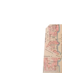
Insurance Plan of London Vol. xi: sheet 398-1
1 : 480 This detailed 1891 plan of London is one of a series of forty seven sheets in an atlas originally produced to aid insurance companies in assessing fire risks. The building footprints, their use (commercial, residential, educational, etc.), the number of floors and the height of the building, as well as construction materials (and thus risk of burning) and special fire hazards (chemicals, kilns, ovens) were documented in order to estimate premiums. Names of individual businesses, property lines, and addresses were also often recorded. Together these maps provide a rich historical shapshot of the commercial activity and urban landscape of towns and cities at the time. The British Library holds a comprehensive collection of fire insurance plans produced by the London-based firm Charles E. Goad Ltd. dating back to 1885. These plans were made for most important towns and cities of the British Isles at the scales of 1:480 (1 inch to 40 feet), as well as many foreign towns at 1:600 (1 inch to 50 feet). Chas E Goad Limited Chas E Goad Limited
SKETCH PLAN AS LAID OUT FOR BUILDING HOUSES OF THE SECOND AND THIRD RATE OF BUILDINGS AT BATTLE BRIDGE, THE PROPERTY OF ROBERT Mc WILLIAM AND THE TRUSTEES UNDER HIS MARRIAGE SETTLEMENT.
Plan for proposed new buildings at Battle Bridge, the site where King's Cross railway station now stands. Standidge & Lemon
London VII.24 - OS London Town Plan
1 : 1056 Topographic maps Ordnance Survey Ordnance Survey
London (1915- Numbered sheets) V.6 (includes: Finsbury; Holborn; Islington; St Pancras) - 25 Inch Map
1 : 2500 Topographic maps Ordnance Survey Ordnance Survey
London (First Editions c1850s) XXVI (includes: Finsbury; Holborn; Islington; St Pancras) - 25 Inch Map
1 : 2500 Topographic maps Ordnance Survey Ordnance Survey
Insurance Plan of London North District Vol. D (Key C): sheet 3-1
1 : 480 This detailed 1901 plan of London is one of a series of twenty sheets in an atlas originally produced to aid insurance companies in assessing fire risks. The building footprints, their use (commercial, residential, educational, etc.), the number of floors and the height of the building, as well as construction materials (and thus risk of burning) and special fire hazards (chemicals, kilns, ovens) were documented in order to estimate premiums. Names of individual businesses, property lines, and addresses were also often recorded. Together these maps provide a rich historical shapshot of the commercial activity and urban landscape of towns and cities at the time. The British Library holds a comprehensive collection of fire insurance plans produced by the London-based firm Charles E. Goad Ltd. dating back to 1885. These plans were made for most important towns and cities of the British Isles at the scales of 1:480 (1 inch to 40 feet), as well as many foreign towns at 1:600 (1 inch to 50 feet). Chas E Goad Limited Chas E Goad Limited
A New and Accurate SURVEY of the PARISHES of St. Andrews Holbourn
Plan of the parishes of St. Andrew's, Holborn, St George's, Queen Square, St James's Clerkenwell, St Luke's, Old Street, St Mary's Islington and the Charterhouse Liberty. Cole, B.
Trade Card Map of Islington
T. Starling
ISLINGTON
1 : 12672 Map of the borough of Islington with inset plan of the parish of St Mary's on the left of the plate and note giving information about the borough down the right side of the plate. The plan shows the New River, a man made water course supplying London with fresh water from Hertfordshire. Baker, E.
London VII.NW - OS Six-Inch Map
1 : 10560 Topographic maps Ordnance Survey Ordnance Survey
Poverty map of London, 1891
Charles Booth
Militärgeographische Angaben über England.
Generalstab des Heeres, Abteilung für Kriegskarten u. Vermessungswesen IV. Mil.-Geo
A Plan of the New Intended Road from Paddington to Islington.

A Plan of te Parish of ST MARY ISLINGTON, with the boundaries of the Several Ecclesiastical Districts, Sueveyed by R. Creighton for the Parochial History, BY S. LEWIS, JUNR.
1 : 15840 Plan of the parish of St Mary's Islington, with the nine ecclesiastical districts that make up the parish delineated by pastel colours. Dower, John, Pentonville.
Charles Booth's descriptive map of London poverty 1889
Charles Booth
Insurance Plan of London North District Vol. D: Key Plan
1 : 3600 This "key plan" indicates coverage of the Goad 1901 series of fire insurance maps of London that were originally produced to aid insurance companies in assessing fire risks. The building footprints, their use (commercial, residential, educational, etc.), the number of floors and the height of the building, as well as construction materials (and thus risk of burning) and special fire hazards (chemicals, kilns, ovens) were documented in order to estimate premiums. Names of individual businesses, property lines, and addresses were also often recorded. Together these maps provide a rich historical shapshot of the commercial activity and urban landscape of towns and cities at the time. The British Library holds a comprehensive collection of fire insurance plans produced by the London-based firm Charles E. Goad Ltd. dating back to 1885. These plans were made for most important towns and cities of the British Isles at the scales of 1:480 (1 inch to 40 feet), as well as many foreign towns at 1:600 (1 inch to 50 feet). Chas E Goad Limited Chas E Goad Limited
LONDON 206
This plan for a survey of London was published in Volume VIII of ‘Encyclopaedia Londinensis' in 1814. The plan's title appears above the plan, with a compass star at the top right. St. Paul's Cathedral and other prominent buildings are shown pictorially, with other places of interest indicated by numbers. Jones, George
PLATTE GRONDT Der Verbrande Stadt LONDON
This map was published in Amsterdam aftermath the great fire of 1666. The title in a banner at top right, flanked by City and Royal arms. The design for rebuilding the City is inset in a panel at top left, with an engraved view of the fire in a banner at bottom centre. Below the plan is a description of the fire in Dutch, French and English with a key to streets and buildings. Doornick, Marcus Willemsz
PLAN OF ISLINGTON PARISH
1 : 9744 This detailed plan of the parish of Islington records each property and field boundary and even indicates the layout of the gardens and trees. A vignette in the lower right corner shows a view of Canonbury from 1821. The note at lower left reports the increase in building over the last seven years and the population growth. Dent, R.
PLAN of the Parish of St. Mary. Islington
This is a plan of the parish of St Mary's, Islington, with three vignettes depicting the Scotch Church, the New Church and St Peter's Chapel down the right of the plate. Baker, B.
Insurance Plan of London North North West District Vol. D: Key Plan
1 : 10560 This "key plan" indicates coverage of the Goad 1892 series of fire insurance maps of London that were originally produced to aid insurance companies in assessing fire risks. The building footprints, their use (commercial, residential, educational, etc.), the number of floors and the height of the building, as well as construction materials (and thus risk of burning) and special fire hazards (chemicals, kilns, ovens) were documented in order to estimate premiums. Names of individual businesses, property lines, and addresses were also often recorded. Together these maps provide a rich historical shapshot of the commercial activity and urban landscape of towns and cities at the time. The British Library holds a comprehensive collection of fire insurance plans produced by the London-based firm Charles E. Goad Ltd. dating back to 1885. These plans were made for most important towns and cities of the British Isles at the scales of 1:480 (1 inch to 40 feet), as well as many foreign towns at 1:600 (1 inch to 50 feet). Chas E Goad Limited Chas E Goad Limited
A new PLAN of LONDON, WESTMINSTER and SOUTHWARK 85
This map of London, Westminster and Southwark was published in John Strype's 1720''Survey of the Cities of London and Westminster''. The map's title is at top centre in ornamental cartouche, surrounded by cherubs, fruits and mythological figures. Dedication to Sir George Thorold, Lord Mayor of London appears at top right, facing the city arms at top left. A compass star is depicted at middle right and a scale bar at bottom right. Strype, John
The LONDON DIRECTORY, or a New & Improved PLAN of LONDON, WESTMINSTER, & SOUTHWARK
This is the fifth edition of a map originally published in 1771 by John Bowles. His name has been replaced by the imprint of Robert Wilkinson, the reissuer. This map highlights the London Wall in red, and colours the city in pink. It uses arrows to show the direction of water-flow in the Thames. There are some additions to the map near Foundling Hospital. Bowles, John
The LONDON DIRECTORY, or a New & Improved PLAN of LONDON, WESTMINSTER, & SOUTHWARK; 182
This map is a reissue of a map published in 1771 by John Bowles. Bowles's name has been replaced by that of Robert Wilkinson, the reissuer. A table of references to churches and public buildings appears below the map. The built-up area of the city is stippled, with other built-up areas done in crosshatching. Coloured lines delineate individual city wards. Bowles, John
The LONDON DIRECTORY, or a New & Improved PLAN of LONDON, WESTMINSTER, & SOUTHWARK; 152
Robert Laurie was a fine mezzotint engraver and regular exhibitor at the Society of Artists in the 1770s. He acquired the stock of surveyor John Sayer’s in 1794 and, in partnership with James Whittle, founded the map publishing firm Laurie & Whittle. This map is very similar to the 1765 map by Robert Sayer and is probably from the same plate. Blackfriars Bridge is shown along with its proposed approaches. Laurie, Robert, and Whittle, James.
The LONDON DIRECTORY, or a New & Improved PLAN of LONDON, WESTMINSTER & SOUTHWARK;
The title of this map appears along the top, with a key in panel below the plan and letters along the borders for reference. Sayer's maps of London, largely derivative, were issued with few alterations throughout the middle years of the 18th Century. This is a later edition of a map he first published in 1765, updated to include the approaches to Blackfriars Bridge, which did not feature in the first edition. Sayer, Robert
The LONDON DIRECTORY, or a New & Improved PLAN of LONDON,
Robert Sayer, the surveyor, traded as a map publisher and print seller in Fleet Street in the latter half of the 18th Century. Between 1751 and 1770and againfrom1784to 1794, he published maps under his own name or under the imprint of Sayer and Bennett. This is the 11th edition of a map published 14 times over a period of 27 years. During this time Robert Sayer became joined in partnership with John Bennett, with their joint imprint appearing on the third to eighth editions. The area of the city is highlighted in pink. A table of references for churches and public buildings appears below the map. In 1794 Sayers stock was acquired by Robert Laurie who founded the map publishing firm of Laurie & Whittle, with his friend James Whittle. Sayer, Robert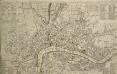
A NEW and CORRECT PLAN of the CITIES of LONDON, WESTMINSTER, and BOROUGH of SOUTHWARK wherein all the Streets, Roads, Churches, Public Buildings &c. to the Present Year 1775 are exactly Delineated
The title of this map runs along the top of the plan. The city boundaries are outlined in yellow, with a key to public buildings in London and Westminster in a table at top left. A list of parishes in Middlesex and Surrey features at top right, alongside a list of city wards and prominent London buildings. An inventory of churches in the City of London appears at bottom left and bottom right. The map shows the proposed new bridge and approaches at Blackfriars and all the proposed roads across St. George's Fields in Southwark, though not as finally laid out. Kitchin, Thomas