Maps of Hackney

Insurance Plan of London Vol. xi: sheet 383-4
1 : 480 This detailed 1891 plan of London is one of a series of forty seven sheets in an atlas originally produced to aid insurance companies in assessing fire risks. The building footprints, their use (commercial, residential, educational, etc.), the number of floors and the height of the building, as well as construction materials (and thus risk of burning) and special fire hazards (chemicals, kilns, ovens) were documented in order to estimate premiums. Names of individual businesses, property lines, and addresses were also often recorded. Together these maps provide a rich historical shapshot of the commercial activity and urban landscape of towns and cities at the time. The British Library holds a comprehensive collection of fire insurance plans produced by the London-based firm Charles E. Goad Ltd. dating back to 1885. These plans were made for most important towns and cities of the British Isles at the scales of 1:480 (1 inch to 40 feet), as well as many foreign towns at 1:600 (1 inch to 50 feet). Chas E Goad Limited Chas E Goad Limited
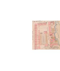
Insurance Plan of London Vol. xi: sheet 382-3
1 : 480 This detailed 1891 plan of London is one of a series of forty seven sheets in an atlas originally produced to aid insurance companies in assessing fire risks. The building footprints, their use (commercial, residential, educational, etc.), the number of floors and the height of the building, as well as construction materials (and thus risk of burning) and special fire hazards (chemicals, kilns, ovens) were documented in order to estimate premiums. Names of individual businesses, property lines, and addresses were also often recorded. Together these maps provide a rich historical shapshot of the commercial activity and urban landscape of towns and cities at the time. The British Library holds a comprehensive collection of fire insurance plans produced by the London-based firm Charles E. Goad Ltd. dating back to 1885. These plans were made for most important towns and cities of the British Isles at the scales of 1:480 (1 inch to 40 feet), as well as many foreign towns at 1:600 (1 inch to 50 feet). Chas E Goad Limited Chas E Goad Limited
London VII.39 - OS London Town Plan
1 : 1056 Topographic maps Ordnance Survey Ordnance Survey
Insurance Plan of London Vol. xi Regent's Canal and Vicinity: Key Plan 1
1 : 4800 This "key plan" indicates coverage of the Goad 1891 series of fire insurance maps of London that were originally produced to aid insurance companies in assessing fire risks. The building footprints, their use (commercial, residential, educational, etc.), the number of floors and the height of the building, as well as construction materials (and thus risk of burning) and special fire hazards (chemicals, kilns, ovens) were documented in order to estimate premiums. Names of individual businesses, property lines, and addresses were also often recorded. Together these maps provide a rich historical shapshot of the commercial activity and urban landscape of towns and cities at the time. The British Library holds a comprehensive collection of fire insurance plans produced by the London-based firm Charles E. Goad Ltd. dating back to 1885. These plans were made for most important towns and cities of the British Isles at the scales of 1:480 (1 inch to 40 feet), as well as many foreign towns at 1:600 (1 inch to 50 feet). Chas E Goad Limited Chas E Goad Limited
London (1915- Numbered sheets) V.8 (includes: Bethnal Green; Hackney; Poplar Borough; Stepney) - 25 Inch Map
1 : 2500 Topographic maps Ordnance Survey Ordnance Survey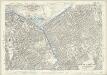
London (Edition of 1894-96) LII (includes: Bethnal Green; Hackney; Poplar Borough; Stepney) - 25 Inch Map
1 : 2500 Topographic maps Ordnance Survey Ordnance Survey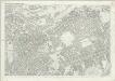
London (First Editions c1850s) XXVIII (includes: Bethnal Green; Hackney; Poplar Borough; Stepney) - 25 Inch Map
1 : 2500 Topographic maps Ordnance Survey Ordnance Survey
Insurance Plan of London Vol. xi Regent's Canal and Vicinity: Key Plan 3
1 : 4800 This "key plan" indicates coverage of the Goad 1891 series of fire insurance maps of London that were originally produced to aid insurance companies in assessing fire risks. The building footprints, their use (commercial, residential, educational, etc.), the number of floors and the height of the building, as well as construction materials (and thus risk of burning) and special fire hazards (chemicals, kilns, ovens) were documented in order to estimate premiums. Names of individual businesses, property lines, and addresses were also often recorded. Together these maps provide a rich historical shapshot of the commercial activity and urban landscape of towns and cities at the time. The British Library holds a comprehensive collection of fire insurance plans produced by the London-based firm Charles E. Goad Ltd. dating back to 1885. These plans were made for most important towns and cities of the British Isles at the scales of 1:480 (1 inch to 40 feet), as well as many foreign towns at 1:600 (1 inch to 50 feet). Chas E Goad Limited Chas E Goad Limited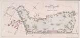
PLAN FOR LAYING OUT THE PROPOSED Eastern Park TO BE CALLED VICTORIA PARK
1 : 4320 The title and imprint of the proposed park in Hackney with title appear at top centre,with a scale bar at bottom centre. The plan was commissioned by the House of Commons and issued in the 18th report of the Commission of Wood, Forests and Land Revenues. The project of a public park in the East End of London was financed by the sale of York House in St. James, Piccadilly. The park, designed by Pennethorne, opened to the public in 1845. Chawner, Thomas
The Jew in London. A study of racial character and present-day conditions.
Arkill, G.E. T. Fisher Unwin
London VII.NE - OS Six-Inch Map
1 : 10560 Topographic maps Ordnance Survey Ordnance Survey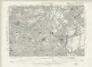
Essex LXXIII.SW - OS Six-Inch Map
1 : 10560 Topographic maps Ordnance Survey Ordnance Survey
Handy Reference Atlas of London
Edinburgh : John Bartholomew & Co.,
A NEW PLAN of the CITY of LONDON and BOROUGH OF SOUTHWARK, Exhibiting all the New Streets & Roads &c. Not extant in any other Plan.
1 : 14080 Thomas Jeffreys was an exceptional cartographer and publisher whose productions included maps of North America, considered to be among the finest of the time.This map of the City of London and the Borough of Southwark shows important buildings such as the Tower of London and St Paul's in plan form, differing from many earlier examples, which show them in elevation. It is dedicated to the Right Honourable Lord Mayor Aldermen and to the Commissioners of the Sewers, Lamps and Pavements. Jeffreys, Thomas
Zielgebeit II London
Der Oberbefehlshaber der Luftwaffe, Führungsstab IC
Insurance Plan of London North & North-East District Vol. E: Key Plan
1 : 21120 This "key plan" indicates coverage of the Goad 1899 series of fire insurance maps of London that were originally produced to aid insurance companies in assessing fire risks. The building footprints, their use (commercial, residential, educational, etc.), the number of floors and the height of the building, as well as construction materials (and thus risk of burning) and special fire hazards (chemicals, kilns, ovens) were documented in order to estimate premiums. Names of individual businesses, property lines, and addresses were also often recorded. Together these maps provide a rich historical shapshot of the commercial activity and urban landscape of towns and cities at the time. The British Library holds a comprehensive collection of fire insurance plans produced by the London-based firm Charles E. Goad Ltd. dating back to 1885. These plans were made for most important towns and cities of the British Isles at the scales of 1:480 (1 inch to 40 feet), as well as many foreign towns at 1:600 (1 inch to 50 feet). Chas E Goad Limited Chas E Goad Limited
Charles Booth's 'Descriptive Map of London Poverty'. Detail showing the City of London and the East End
The East End of London is the hell of poverty. Like one enormous black, motionless giant kraken, the poverty of London lies there in lurking silence and encircles with its mighty tentacles the life and wealth of the City. So wrote J H Mackay in 1891. It was acknowledged that the blame lay with overcrowded housing and with a surplus of labour, which kept wages low for those lucky enough to find work. Statistics for 1888 showed that the East End had 8,465 official paupers - people 'living rough'. According to Charles Booth's survey in 1889, over a third of its inhabitants lived on or below the margin of poverty. His 17-volume survey included this coloured-coded map indicating London's poverty and prosperity street by street. The key to the colours used is as follows: Gold: Upper-middle and Upper classes.Wealthy. Red: Well-to-do. Middle-class. Pink: Fairly comfortable. Good ordinary earning. Purple: Mixed. Some comfortable, others poor. Pale Blue: Poor. 18s. to 21s. a week for moderate family Dark blue: Very poor, casual. Chronic want. Black: Lowest class. Vicious, semi-criminal. Booth, Charles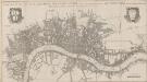
A NEW MAP OF THE CITYES OF LONDON, WESTMINSTER AND THE BURROUGH OF SOUTHWARK TOGETHER WITH THE SUBURBS AS THEY ARE NOW STANDDING Anno Dom.1707.
This title of this map of London appears along the top, with the city arms at top left and the publisher’s name in cartouche at top right. The map appeared in Volume I of 'A New View of London', by Edward Hutton. Chiswell, Richard et al.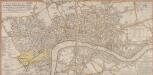
A New and Complete Plan of LONDON, WESTMINSTER & BOROUGH OF SOUTHWARK containing the Improvements IN, and ROUND the METROPOLIS
Roads and open spaces are depicted in different colours and margins divided into miles and furlongs. The map’s title and a list of districts in Westminster are at the top left, with a key to public offices and Westminster parishes at the bottom left. The fares of hackney coaches and water ferries are at the bottom right, along with a list of Surrey parishes. At middle right, there is a list of parishes within the 'Bill of Mortality' - the name given to parishes who sent regular death notices to the central London government. A fine mezzotint engraver and regular exhibitor at the Society of Artists in the 1770s, Robert Laurie acquired Sayer’s stock in 1794 and (with James Whittle) founded the map publishing house Laurie & Whittle. Laurie, Robert and Whittle, James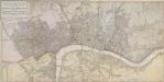
A NEW POCKET PLAN OF THE CITIES OF LONDON & WESTMINSTER WITH THE BOROUGH OF SOUTHWARK: Comprehending the New Buildings and other Alterations to the Year 1790
This is the third edition of William Faden's 1787 map, which was printed 11 times over a period of 25 years. Faden called himself "Geographer to the King”, and was very interested the work of the Ordnance Survey. In 1800 he published 'An account of the operations carried on for accomplishing a trigonometrical survey of England and Wales'. Faden's skill as a cartographer was so well-noted that his map of 'The Country Twenty-Five Miles round London' was re-engraved for the French War Department in preparation for an invasion of England. This map includes a list of Surrey Parishes within the Bills of Mortality, an area of 109 parishes in and near London from which a weekly report of deaths was collated. Westminster is divided into 12 districts, each indicated by coloured boundaries. William Faden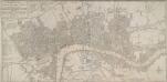
BOWLES'S NEW POCKET PLAN OF THE CITIES OF LONDON & WESTMINSTER; WITH THE BOROUGH OF SOUTHWARK: Comprehending the New Buildings and other Alterations to the Year 1780
This map was printed for Caringtom Bowles who traded from a St. Paul's churchyard. The Bowles family were not cartographers but published and sold maps. This is the fourth edition of a map originally issued in 1773.The title is at top left, next to a list of parishes, with a key to Great Offices of State and Westminster parishes down the left of the plate. The border of the map is marked off in miles and furlongs. There is no discernible difference between this edition and the previous ones. Bowles, Carington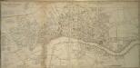
A NEW PLAN of the CITY AND LIBERTY of WESTMINSTER
The engraver-turned-cartographer Thomas Jeffrey began commissioning original surveys for a series of English county maps in the early 1760s. This is the combination of two separate maps: a map of Westminster, with a list of districts and parishes in the County of Middlesex; and an adjoining map of London featuring list of parishes in the County of Surrey and key to colours. The map is a later edition of Jeffrey's map of 1766, with the imprint, dedication and City arms omitted, updated to include the New Road, the first London bypass, and the roads across St. George's Fields. Jeffrey, Thomas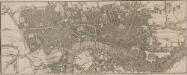
Map of London
This untitled map is a later edition one first published by Phillips in the 1802'Picture of London'. The map is divided into mile squares with letters along the border for reference, and shows the new London Docks. The proposed street layout across the fields in Shoreditch, between Mile End Road and Bethnal Green Road, is indicated by a double dotted line. Phillips, Richard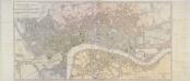
A NEW POCKET PLAN OF THE CITIES OF LONDON & WESTMINSTER WITH THE BOROUGH OF SOUTHWARK
This folding map of London is the eighth edition of a map first published by Faden in 1787. It features title at top left, table of parishes next to the title, and scale bar at bottom right. At bottom centre is a list of Surrey parishes within the Bill of Mortality - the name given to the areas from which the London government received regular death notices. The border of the map is divided in miles and furlongs. At the beginning of the 19th Century, the administration of London was split among a multitude of authorities, vestries, special commissions and private enterprises. The nine districts in London are distinguished on the map by areas of different colour, with key to colours and explanation of the relevant civil and military authorities in handwritten notes down both sides of the map. Faden, William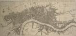
A New and Exact PLAN of the CITIES of LONDON and WESTMINSTER and BOROUGH of SOUTHWARK, with the Additional Buildings to the Year 1756
This map of London was engraved by Seale for publication in John Strype's 1754 edition of Stow's 'Survey of London and Westminster and the Borough of Southwark'. The plan's title features along the top, with compass rose near top left and scale bar below the plan. It illustrates St. Paul's Cathedral and other prominent buildings pictorially. Seale, Richard William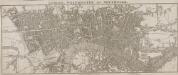
LONDON WESTMINSTER AND SOUTHWARK
The title of this small map runs along the top, with the imprint and scale bar below the plan. The map shows Waterloo Bridge, or Strand Bridge, with the proposed southern approach indicated by a dotted line. Designed by John Rennie, Waterloo Bridge was constructed by a commercial company hoping to profit from toll-paying traffic. The bridge cost 1m and was never profitable. The bridge was demolished and replaced controversially in 1936. Luffman, John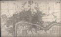
This Actual Survey Of London Westminster Southwark Is Humbly Dedicated To Ye Ld. Mayor & Court of Aldermen
Morden, Robert; Lea, Philip Covens et Mortier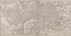
A NEW PLAN OF LONDON AND WESTMINSTER WITH THE BOROUGH OF SOUTHWARK 218
Map of London with the title in a panel at top left, imprint below the plan, key to colours at bottom centre, a scale bar at bottom right and with a list of parishes in tables near bottom left and bottom right. The map is divided into furlong squares printed in red ink and features numbers along the borders for reference. The son of a map publisher, James Wyld attended military college before entering the map trade. He became one of the best-known map publishers of the middle of the 19th Century and during the railway-building mania of those years, his maps of railway developments were often put before parliament. Wyld, James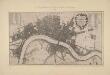
A New Map of the Cities of London and Westminster and Ye Borough of Southwarke with their Suburbs
This is a later edition of Hollar's map of London of 1675 without the prospect view of the City entitled "Prospect of London as it was flourishing before the destruction by fire" that featured in the first edition. The map, with title in cartouche, reference tables and scale bar, is a very minute bird’s eye view of the cities of London and Westminster, with the Borough of Southwark and suburbs showing London after the fire growing in area faster than ever before, with former satellite villages fast becoming mere localities in the urban sprawl. Stepney church, for example, marks a new point of growth east of the city. Hollar, Wenceslaus