Maps of Hackney

Insurance Plan of London Vol. xi: sheet 383-1
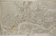
1 : 480 This detailed 1891 plan of London is one of a series of forty seven sheets in an atlas originally produced to aid insurance companies in assessing fire risks. The building footprints, their use (commercial, residential, educational, etc.), the number of floors and the height of the building, as well as construction materials (and thus risk of burning) and special fire hazards (chemicals, kilns, ovens) were documented in order to estimate premiums. Names of individual businesses, property lines, and addresses were also often recorded. Together these maps provide a rich historical shapshot of the commercial activity and urban landscape of towns and cities at the time. The British Library holds a comprehensive collection of fire insurance plans produced by the London-based firm Charles E. Goad Ltd. dating back to 1885. These plans were made for most important towns and cities of the British Isles at the scales of 1:480 (1 inch to 40 feet), as well as many foreign towns at 1:600 (1 inch to 50 feet). Chas E Goad Limited Chas E Goad Limited
London VII.28 - OS London Town Plan
1 : 1056 Topographic maps Ordnance Survey Ordnance Survey
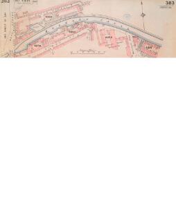
Insurance Plan of London Vol. xi: sheet 384-1
1 : 480 This detailed 1891 plan of London is one of a series of forty seven sheets in an atlas originally produced to aid insurance companies in assessing fire risks. The building footprints, their use (commercial, residential, educational, etc.), the number of floors and the height of the building, as well as construction materials (and thus risk of burning) and special fire hazards (chemicals, kilns, ovens) were documented in order to estimate premiums. Names of individual businesses, property lines, and addresses were also often recorded. Together these maps provide a rich historical shapshot of the commercial activity and urban landscape of towns and cities at the time. The British Library holds a comprehensive collection of fire insurance plans produced by the London-based firm Charles E. Goad Ltd. dating back to 1885. These plans were made for most important towns and cities of the British Isles at the scales of 1:480 (1 inch to 40 feet), as well as many foreign towns at 1:600 (1 inch to 50 feet). Chas E Goad Limited Chas E Goad Limited
Insurance Plan of London Vol. xi Regent's Canal and Vicinity: Key Plan 1
1 : 4800 This "key plan" indicates coverage of the Goad 1891 series of fire insurance maps of London that were originally produced to aid insurance companies in assessing fire risks. The building footprints, their use (commercial, residential, educational, etc.), the number of floors and the height of the building, as well as construction materials (and thus risk of burning) and special fire hazards (chemicals, kilns, ovens) were documented in order to estimate premiums. Names of individual businesses, property lines, and addresses were also often recorded. Together these maps provide a rich historical shapshot of the commercial activity and urban landscape of towns and cities at the time. The British Library holds a comprehensive collection of fire insurance plans produced by the London-based firm Charles E. Goad Ltd. dating back to 1885. These plans were made for most important towns and cities of the British Isles at the scales of 1:480 (1 inch to 40 feet), as well as many foreign towns at 1:600 (1 inch to 50 feet). Chas E Goad Limited Chas E Goad Limited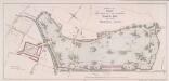
PLAN FOR LAYING OUT THE PROPOSED Eastern Park TO BE CALLED VICTORIA PARK
1 : 4320 The title and imprint of the proposed park in Hackney with title appear at top centre,with a scale bar at bottom centre. The plan was commissioned by the House of Commons and issued in the 18th report of the Commission of Wood, Forests and Land Revenues. The project of a public park in the East End of London was financed by the sale of York House in St. James, Piccadilly. The park, designed by Pennethorne, opened to the public in 1845. Chawner, Thomas
London VII.NE - OS Six-Inch Map
1 : 10560 Topographic maps Ordnance Survey Ordnance Survey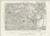
Essex LXXIII.SW - OS Six-Inch Map
1 : 10560 Topographic maps Ordnance Survey Ordnance Survey
Handy Reference Atlas of London
Edinburgh : John Bartholomew & Co.,
Militärgeographische Angaben über England.
Generalstab des Heeres, Abteilung für Kriegskarten u. Vermessungswesen IV. Mil.-Geo
Insurance Plan of London North & North-East District Vol. E: Key Plan
1 : 21120 This "key plan" indicates coverage of the Goad 1899 series of fire insurance maps of London that were originally produced to aid insurance companies in assessing fire risks. The building footprints, their use (commercial, residential, educational, etc.), the number of floors and the height of the building, as well as construction materials (and thus risk of burning) and special fire hazards (chemicals, kilns, ovens) were documented in order to estimate premiums. Names of individual businesses, property lines, and addresses were also often recorded. Together these maps provide a rich historical shapshot of the commercial activity and urban landscape of towns and cities at the time. The British Library holds a comprehensive collection of fire insurance plans produced by the London-based firm Charles E. Goad Ltd. dating back to 1885. These plans were made for most important towns and cities of the British Isles at the scales of 1:480 (1 inch to 40 feet), as well as many foreign towns at 1:600 (1 inch to 50 feet). Chas E Goad Limited Chas E Goad Limited
Charles Booth's 'Descriptive Map of London Poverty'. Detail showing the City of London and the East End
The East End of London is the hell of poverty. Like one enormous black, motionless giant kraken, the poverty of London lies there in lurking silence and encircles with its mighty tentacles the life and wealth of the City. So wrote J H Mackay in 1891. It was acknowledged that the blame lay with overcrowded housing and with a surplus of labour, which kept wages low for those lucky enough to find work. Statistics for 1888 showed that the East End had 8,465 official paupers - people 'living rough'. According to Charles Booth's survey in 1889, over a third of its inhabitants lived on or below the margin of poverty. His 17-volume survey included this coloured-coded map indicating London's poverty and prosperity street by street. The key to the colours used is as follows: Gold: Upper-middle and Upper classes.Wealthy. Red: Well-to-do. Middle-class. Pink: Fairly comfortable. Good ordinary earning. Purple: Mixed. Some comfortable, others poor. Pale Blue: Poor. 18s. to 21s. a week for moderate family Dark blue: Very poor, casual. Chronic want. Black: Lowest class. Vicious, semi-criminal. Booth, Charles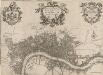
A new PLAN of LONDON, WESTMINSTER and SOUTHWARK 85
This map of London, Westminster and Southwark was published in John Strype's 1720''Survey of the Cities of London and Westminster''. The map's title is at top centre in ornamental cartouche, surrounded by cherubs, fruits and mythological figures. Dedication to Sir George Thorold, Lord Mayor of London appears at top right, facing the city arms at top left. A compass star is depicted at middle right and a scale bar at bottom right. Strype, John
Rowe's map of London, westminster and Southwark, exhibiting the various improvements to the year 1804, detail showing the London and west india Docks
A canal and the two West India docks now cut across the neck of the Isle of Dogs to provide shipping with a shortcut across its marshy peninsular. A wall around its edge holds back the tidal Thames while windmills on the windy west side pump water from the marsh. As industry spreads, wealthy residents are lured away to the fashionable new suburbs rising to the west of London. Turnpikes appear, on the Hackney Road for example: an indication of the growing need for good roads and the money to maintain them. From the tangle of older streets, the line of the proposed new Commercial Road shoots straight across the open fields. Rowe
The LONDON DIRECTORY, or a New & Improved PLAN of LONDON, WESTMINSTER, & SOUTHWARK
This is the fifth edition of a map originally published in 1771 by John Bowles. His name has been replaced by the imprint of Robert Wilkinson, the reissuer. This map highlights the London Wall in red, and colours the city in pink. It uses arrows to show the direction of water-flow in the Thames. There are some additions to the map near Foundling Hospital. Bowles, John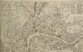
A NEW and CORRECT PLAN of the CITIES of LONDON, WESTMINSTER, and BOROUGH of SOUTHWARK wherein all the Streets, Roads, Churches, Public Buildings &c. to the Present Year 1775 are exactly Delineated
The title of this map runs along the top of the plan. The city boundaries are outlined in yellow, with a key to public buildings in London and Westminster in a table at top left. A list of parishes in Middlesex and Surrey features at top right, alongside a list of city wards and prominent London buildings. An inventory of churches in the City of London appears at bottom left and bottom right. The map shows the proposed new bridge and approaches at Blackfriars and all the proposed roads across St. George's Fields in Southwark, though not as finally laid out. Kitchin, Thomas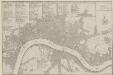
PLANES DES VILLES DE LONDRES ET DE WESTMINSTER et de leurs Faubourges, avec le Bourg de Southwark
The title of this French plan runs along the top of the sheet, with table of references at top left, facing the scale bar and compass rose at top right. This map was included in Nicolas de Fer's "Atlas Curieux". Fer, Nicholas de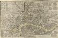
A NEW and CORRECT PLAN of the CITIES of LONDON, WESTMINSTER, and BOROUGH of SOUTHWARK wherein all the Streets, Roads, Churches, Public Buildings &c. To the Present Year 1785 are exactly delineated
Map publisher and print seller Robert Sayer traded from Fleet Street in the latter half of the 18th Century, first under his own name, and then under the joint imprint of Sayer& Bennett. This is a later edition of Sayer& Bennett's 1781 map of London. Coloured outlines appear along the boundaries of the London Wall, Westminster and Southwark. References tables appear in all four corners, listing public buildings, churches and the parishes within the Bills of Mortality (those parishes who reported deaths to the central London government). Open land, such as parks and gardens, is highlighted in green. R. Sayer & J. Bennett
The LONDON DIRECTORY, or a New & Improved PLAN of LONDON, WESTMINSTER, & SOUTHWARK; 157
This is the eighth edition of the an original 1765Sayer map. Bennett’s name was added to the imprint of the third edition of the map, published in 1776. The two men were in partnership between 1770 and 1787.Their business was taken over by Laurie and Whittle in 1792. R. Sayer & J. Bennett
BOWLES'S Reduced NEW POCKET PLAN of the CITIES of LONDON and WESTMINSTER, with the BOROUGH of SOUTHWARK, exhibiting the NEW BUILDINGS to the YEAR 1783.
Carrington Bowles (1724-93) came from a family of publishers and map sellers who published a considerable body of work during a century of trading. This is the fifth edition of an original 1777map. It includes a table of references to churches and principal buildings. The built-up areas of the City of London are stippled, with the city and county boundaries delineated by coloured lines. The scale is given in miles or furlongs in the bottom right-hand corner. Carrington Bowles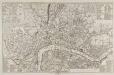
A NEW and CORRECT PLAN of the CITIES of LONDON, WESTMINSTER, and BOROUGH of SOUTHWARK wherein all the Streets, Roads, Churches, Public Buildings &c. To the Present Year 1781 are exactly delineated
A table of references in the top-left corner identifies the Great Offices of State and public buildings. Different colours denote the boundaries of Westminster, Southwark and the City. Sayer, Robert and Bennett, John
Plan of London, Westminster & Southwark

This Actuall Survey Of LONDON, WESTMINSTER AND SOUTHWARK Is humbly Dedicated To Y.e L.d M.Yor & Court Of Aldermen by R.o: Morden, Phil: Lea Chr: Browne
This is a later edition of a very popular map of London first published by Morden and Lea in 1690. The map's title features along the top, with the city arms at top left, facing the publisher's imprint in shield at top right. The reference tables, scale bar and compass rose appear at lower right. The plan marks the city's growth in the late Stuart period, showing its northward spread towards Islington. Morden, Robert & Lea, Philip
London NE.
1 : 15840 Stanford, Edward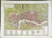
Londres (avec le bourg de Southwark)
1 Plan : Kupferdruck ; 26 x 45 cm, Bildgrösse 32 x 45 cm Mentelle; Tardieu; Dubuisson Mentelle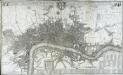
This actual survey of London Westminster Soutwark is humbly dedicated to y.e L.d Mayor [and] court of Aldermen
1 Plan auf 2 Blättern : Kupferdruck ; 58 x 98 cm chez Iean Cóvens et Corneille Mortier libraires et marchands des cartes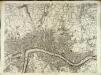
[A plan of London]
1 Plan : Kupferdruck ; 49 x 66 cm Rocque; Parr John Rocque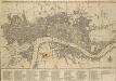
BOWLES'S Reduced NEW POCKET PLAN of the CITIES of LONDON & WESTMINSTER; WITH THE BOROUGH OF SOUTHWARK, exhibiting the New Buildings to the YEAR 1780
The Bowles family were successful map publishers and sellers whose considerable output spanned a century. This map is the second edition of an original 1777plan. It includes a table of references to churches and principal buildings. The built-up areas of the City of London are stippled. The scale is given in miles or furlongs. Bowles, Carington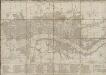
BOWLES'S Reduced NEW POCKET PLAN of the CITIES of LONDON and WESTMINSTER, with the BOROUGH of SOUTHWARK, exhibiting the NEW BUILDINGS to the YEAR 1787.
This is the sixth edition of Bowles's Reduced New Pocket Plan. The map was reissued 11 times between1777 and 1799. It includes a table of references to churches and principal buildings. The built-up areas of the City of London are represented by stippling; with the city boundaries delineated it red. The scale is given in miles and furlongs. Bowles, Carington