Maps of Hackney

Insurance Plan of London Vol. xi: sheet 380-2
1 : 480 This detailed 1891 plan of London is one of a series of forty seven sheets in an atlas originally produced to aid insurance companies in assessing fire risks. The building footprints, their use (commercial, residential, educational, etc.), the number of floors and the height of the building, as well as construction materials (and thus risk of burning) and special fire hazards (chemicals, kilns, ovens) were documented in order to estimate premiums. Names of individual businesses, property lines, and addresses were also often recorded. Together these maps provide a rich historical shapshot of the commercial activity and urban landscape of towns and cities at the time. The British Library holds a comprehensive collection of fire insurance plans produced by the London-based firm Charles E. Goad Ltd. dating back to 1885. These plans were made for most important towns and cities of the British Isles at the scales of 1:480 (1 inch to 40 feet), as well as many foreign towns at 1:600 (1 inch to 50 feet). Chas E Goad Limited Chas E Goad Limited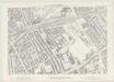
London VII.49 - OS London Town Plan
1 : 1056 Topographic maps Ordnance Survey Ordnance Survey
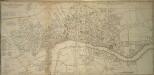
A Map of the Parish of St. Dunstans Stepney, als. Stebunheath.
A. Churchill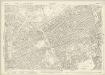
London (1915- Numbered sheets) V.8 (includes: Bethnal Green; Hackney; Poplar Borough; Stepney) - 25 Inch Map
1 : 2500 Topographic maps Ordnance Survey Ordnance Survey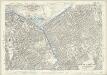
London (Edition of 1894-96) LII (includes: Bethnal Green; Hackney; Poplar Borough; Stepney) - 25 Inch Map
1 : 2500 Topographic maps Ordnance Survey Ordnance Survey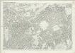
London (First Editions c1850s) XXVIII (includes: Bethnal Green; Hackney; Poplar Borough; Stepney) - 25 Inch Map
1 : 2500 Topographic maps Ordnance Survey Ordnance Survey
Insurance Plan of London Vol. xi Regent's Canal and Vicinity: Key Plan 3
1 : 4800 This "key plan" indicates coverage of the Goad 1891 series of fire insurance maps of London that were originally produced to aid insurance companies in assessing fire risks. The building footprints, their use (commercial, residential, educational, etc.), the number of floors and the height of the building, as well as construction materials (and thus risk of burning) and special fire hazards (chemicals, kilns, ovens) were documented in order to estimate premiums. Names of individual businesses, property lines, and addresses were also often recorded. Together these maps provide a rich historical shapshot of the commercial activity and urban landscape of towns and cities at the time. The British Library holds a comprehensive collection of fire insurance plans produced by the London-based firm Charles E. Goad Ltd. dating back to 1885. These plans were made for most important towns and cities of the British Isles at the scales of 1:480 (1 inch to 40 feet), as well as many foreign towns at 1:600 (1 inch to 50 feet). Chas E Goad Limited Chas E Goad Limited
Insurance Plan of London: sheet 8
This detailed 1889 plan of London is one of a series of six sheets in an atlas originally produced to aid insurance companies in assessing fire risks. The building footprints, their use (commercial, residential, educational, etc.), the number of floors and the height of the building, as well as construction materials (and thus risk of burning) and special fire hazards (chemicals, kilns, ovens) were documented in order to estimate premiums. Names of individual businesses, property lines, and addresses were also often recorded. Together these maps provide a rich historical shapshot of the commercial activity and urban landscape of towns and cities at the time. The British Library holds a comprehensive collection of fire insurance plans produced by the London-based firm Charles E. Goad Ltd. dating back to 1885. These plans were made for most important towns and cities of the British Isles at the scales of 1:480 (1 inch to 40 feet), as well as many foreign towns at 1:600 (1 inch to 50 feet). Chas E Goad Limited Chas E Goad Limited
Vrbium Londini et West-Monasterii nec non suburbii Southwark accurata ichnographia, 3
1 Blatt : 53 x 57 cm Homännische Erben
The Jew in London. A study of racial character and present-day conditions.
Arkill, G.E. T. Fisher Unwin
London VII.NE - OS Six-Inch Map
1 : 10560 Topographic maps Ordnance Survey Ordnance Survey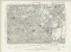
Essex LXXIII.SW - OS Six-Inch Map
1 : 10560 Topographic maps Ordnance Survey Ordnance Survey
Newcourt's 'Map of London', detail showing the East End
Richard Newcourt’s map, made in 1658, represents the first complete survey of London since the 1550s. It shows the City and its surrounding countryside in the closing years of the Commonwealth. Though most buildings are depicted in a conventionalised way, the map gives some idea of the actual appearance of more important places, such as churches and livery halls. The inclusion of their coats of arms in the map's decoration suggests the Livery Companies may have commissioned Newcourt's work. The map provides a fairly accurate picture of the development of the City's eastern suburbs, already spreading along the roads that reached out across the countryside towards the surrounding villages. As well as being the docklands of London, this was the area where the first native English school of chartmaking, the so-called 'Thames School', was getting underway at the very time this map was made. Newcourt, Richard
Handy Reference Atlas of London
Edinburgh : John Bartholomew & Co.,
A NEW PLAN of the CITY of LONDON and BOROUGH OF SOUTHWARK, Exhibiting all the New Streets & Roads &c. Not extant in any other Plan.
1 : 14080 Thomas Jeffreys was an exceptional cartographer and publisher whose productions included maps of North America, considered to be among the finest of the time.This map of the City of London and the Borough of Southwark shows important buildings such as the Tower of London and St Paul's in plan form, differing from many earlier examples, which show them in elevation. It is dedicated to the Right Honourable Lord Mayor Aldermen and to the Commissioners of the Sewers, Lamps and Pavements. Jeffreys, Thomas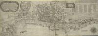
The Newest and Exactest MAPP of the most Famous Citties LONDON and WESTMINSTER, with their Suburbs; and the manner of their Streets:
The arms of the Commonwealth and of the City appear on the upper-left cornermap, facing the personifications of Justice and Prudence on the upper right. A number key is provided so users can find "the nearest way from one place to another." 'Pecadilly Hall' appears in place of modern Piccadilly. This was a derisive name for the country house built around1612 by Robert Baker, a tailor with a shop on the Strand. Baker made his fortune by selling "picadils" (a stiff collar popular at Court). By the 18th Century, Piccadilly was the name of the whole street. Porter, T.
Insurance Plan of London North & North-East District Vol. E: Key Plan
1 : 21120 This "key plan" indicates coverage of the Goad 1899 series of fire insurance maps of London that were originally produced to aid insurance companies in assessing fire risks. The building footprints, their use (commercial, residential, educational, etc.), the number of floors and the height of the building, as well as construction materials (and thus risk of burning) and special fire hazards (chemicals, kilns, ovens) were documented in order to estimate premiums. Names of individual businesses, property lines, and addresses were also often recorded. Together these maps provide a rich historical shapshot of the commercial activity and urban landscape of towns and cities at the time. The British Library holds a comprehensive collection of fire insurance plans produced by the London-based firm Charles E. Goad Ltd. dating back to 1885. These plans were made for most important towns and cities of the British Isles at the scales of 1:480 (1 inch to 40 feet), as well as many foreign towns at 1:600 (1 inch to 50 feet). Chas E Goad Limited Chas E Goad Limited
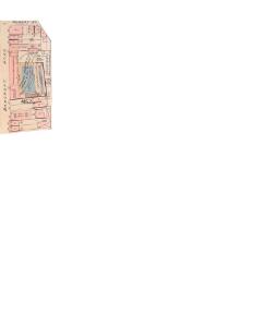
Charles Booth's 'Descriptive Map of London Poverty'. Detail showing the City of London and the East End
The East End of London is the hell of poverty. Like one enormous black, motionless giant kraken, the poverty of London lies there in lurking silence and encircles with its mighty tentacles the life and wealth of the City. So wrote J H Mackay in 1891. It was acknowledged that the blame lay with overcrowded housing and with a surplus of labour, which kept wages low for those lucky enough to find work. Statistics for 1888 showed that the East End had 8,465 official paupers - people 'living rough'. According to Charles Booth's survey in 1889, over a third of its inhabitants lived on or below the margin of poverty. His 17-volume survey included this coloured-coded map indicating London's poverty and prosperity street by street. The key to the colours used is as follows: Gold: Upper-middle and Upper classes.Wealthy. Red: Well-to-do. Middle-class. Pink: Fairly comfortable. Good ordinary earning. Purple: Mixed. Some comfortable, others poor. Pale Blue: Poor. 18s. to 21s. a week for moderate family Dark blue: Very poor, casual. Chronic want. Black: Lowest class. Vicious, semi-criminal. Booth, Charles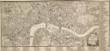
A PLAN of the CITIES of LONDON AND WESTMINSTER and BOROUGH of SOUTHWARK 1771
The reference key of this map extends along the right margin and bottom of the map, with the title is in a cartouche. This map shows proposed lines of approach towards Blackfriars Bridge, later abandoned. Andrews, J.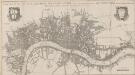
A NEW MAP OF THE CITYES OF LONDON, WESTMINSTER AND THE BURROUGH OF SOUTHWARK TOGETHER WITH THE SUBURBS AS THEY ARE NOW STANDDING Anno Dom.1707.
This title of this map of London appears along the top, with the city arms at top left and the publisher’s name in cartouche at top right. The map appeared in Volume I of 'A New View of London', by Edward Hutton. Chiswell, Richard et al.
London
1 : 50000 Londýn (Anglie) Hollar, Václav Blome, Richard Ric. Blome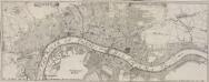
LONDEN, WESTMUNSTER U: SOUDWARK
The title of this German map of London, Westminster and Southwark, appears between two ribbons at the top. A compass rose appears in the river, with prominent buildings shown pictorially instead of in plan and numbered for reference. Stridbeck, Johannes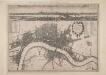
A New Map of the Cities of London and Westminster and Ye Borough of Southwarke with the Suburbs
Large map of London with prospect view of the City from Bankside in a strip above the main plan. Entitled "Prospect of London as it was flourishing before the destruction by fire", the view is based on Hollar's celebrated view of London from Bankside of 1647 and shows London from Worcester House (just west of the Savoy) on the west to Wapping and St Catherine's Docks to the east. The view shows London before the fire being composed almost exclusively of Gothic buildings, Inigo Jones’s Banqueting Hall at Whitehall and the classical restoration of St. Paul’s cathedral being the only examples of Renaissance architecture. The map, with title in cartouche, reference tables at top right and top left and scale bar at bottom centre, is a very minute bird's eye view of the cities of London and Westminster, the borough of Southwark and the suburbs showing London after the fire growing in area faster than ever before. Stepney Church, for example, marks a new point of growth east of the city. Hollar, Wenceslaus
Plan von London und Westminster mit der Borough von Southwark
Londýn (Anglie)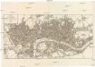
PLAN von LONDON und WESTMINSTER mit der BOROUGH von SOUTHWARK
Londýn (Anglie)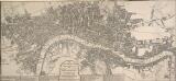
The LONDON GUIDE, or A POCKET PLAN of the CITIES OF LONDON & WESTMINSTER and BOROUGH of SOUTHWARK with the BEW BUILDINGS, &C to the present year
This map of Georgian London was published in John Entick's 1766'A New and Accurate History and Survey of London, Westminster and Southwark.' The title of the map appears in a panel below the plan along with the rates of hackney coaches and water ferries. It extends eastward to include Limehouse, then one of the main centres for shipbuilding in the capital. Bowles, Carington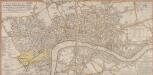
A New and Complete Plan of LONDON, WESTMINSTER & BOROUGH OF SOUTHWARK containing the Improvements IN, and ROUND the METROPOLIS
Roads and open spaces are depicted in different colours and margins divided into miles and furlongs. The map’s title and a list of districts in Westminster are at the top left, with a key to public offices and Westminster parishes at the bottom left. The fares of hackney coaches and water ferries are at the bottom right, along with a list of Surrey parishes. At middle right, there is a list of parishes within the 'Bill of Mortality' - the name given to parishes who sent regular death notices to the central London government. A fine mezzotint engraver and regular exhibitor at the Society of Artists in the 1770s, Robert Laurie acquired Sayer’s stock in 1794 and (with James Whittle) founded the map publishing house Laurie & Whittle. Laurie, Robert and Whittle, James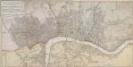
A NEW POCKET PLAN OF THE CITIES OF LONDON & WESTMINSTER WITH THE BOROUGH OF SOUTHWARK: Comprehending the New Buildings and other Alterations to the Year 1790
This is the third edition of William Faden's 1787 map, which was printed 11 times over a period of 25 years. Faden called himself "Geographer to the King”, and was very interested the work of the Ordnance Survey. In 1800 he published 'An account of the operations carried on for accomplishing a trigonometrical survey of England and Wales'. Faden's skill as a cartographer was so well-noted that his map of 'The Country Twenty-Five Miles round London' was re-engraved for the French War Department in preparation for an invasion of England. This map includes a list of Surrey Parishes within the Bills of Mortality, an area of 109 parishes in and near London from which a weekly report of deaths was collated. Westminster is divided into 12 districts, each indicated by coloured boundaries. William Faden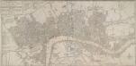
BOWLES'S NEW POCKET PLAN OF THE CITIES OF LONDON & WESTMINSTER; WITH THE BOROUGH OF SOUTHWARK: Comprehending the New Buildings and other Alterations to the Year 1780
This map was printed for Caringtom Bowles who traded from a St. Paul's churchyard. The Bowles family were not cartographers but published and sold maps. This is the fourth edition of a map originally issued in 1773.The title is at top left, next to a list of parishes, with a key to Great Offices of State and Westminster parishes down the left of the plate. The border of the map is marked off in miles and furlongs. There is no discernible difference between this edition and the previous ones. Bowles, Carington