Maps of Camden

Insurance Plan of London Vol. xi: sheet 372-2
1 : 480 This detailed 1891 plan of London is one of a series of forty seven sheets in an atlas originally produced to aid insurance companies in assessing fire risks. The building footprints, their use (commercial, residential, educational, etc.), the number of floors and the height of the building, as well as construction materials (and thus risk of burning) and special fire hazards (chemicals, kilns, ovens) were documented in order to estimate premiums. Names of individual businesses, property lines, and addresses were also often recorded. Together these maps provide a rich historical shapshot of the commercial activity and urban landscape of towns and cities at the time. The British Library holds a comprehensive collection of fire insurance plans produced by the London-based firm Charles E. Goad Ltd. dating back to 1885. These plans were made for most important towns and cities of the British Isles at the scales of 1:480 (1 inch to 40 feet), as well as many foreign towns at 1:600 (1 inch to 50 feet). Chas E Goad Limited Chas E Goad Limited
London VII.22 - OS London Town Plan
1 : 1056 Topographic maps Ordnance Survey Ordnance Survey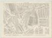
London VII.23 - OS London Town Plan
1 : 1056 Topographic maps Ordnance Survey Ordnance Survey
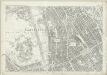
Insurance Plan of London Vol. xi: sheet 400-1
1 : 480 This detailed 1891 plan of London is one of a series of forty seven sheets in an atlas originally produced to aid insurance companies in assessing fire risks. The building footprints, their use (commercial, residential, educational, etc.), the number of floors and the height of the building, as well as construction materials (and thus risk of burning) and special fire hazards (chemicals, kilns, ovens) were documented in order to estimate premiums. Names of individual businesses, property lines, and addresses were also often recorded. Together these maps provide a rich historical shapshot of the commercial activity and urban landscape of towns and cities at the time. The British Library holds a comprehensive collection of fire insurance plans produced by the London-based firm Charles E. Goad Ltd. dating back to 1885. These plans were made for most important towns and cities of the British Isles at the scales of 1:480 (1 inch to 40 feet), as well as many foreign towns at 1:600 (1 inch to 50 feet). Chas E Goad Limited Chas E Goad Limited
Goad Fire Insurance Plan of London
London: Chas. E. Goad
Insurance Plan of London Vol. xi: sheet 402-1
1 : 480 This detailed 1891 plan of London is one of a series of forty seven sheets in an atlas originally produced to aid insurance companies in assessing fire risks. The building footprints, their use (commercial, residential, educational, etc.), the number of floors and the height of the building, as well as construction materials (and thus risk of burning) and special fire hazards (chemicals, kilns, ovens) were documented in order to estimate premiums. Names of individual businesses, property lines, and addresses were also often recorded. Together these maps provide a rich historical shapshot of the commercial activity and urban landscape of towns and cities at the time. The British Library holds a comprehensive collection of fire insurance plans produced by the London-based firm Charles E. Goad Ltd. dating back to 1885. These plans were made for most important towns and cities of the British Isles at the scales of 1:480 (1 inch to 40 feet), as well as many foreign towns at 1:600 (1 inch to 50 feet). Chas E Goad Limited Chas E Goad Limited
Insurance Plan of London Vol. xi: sheet 403
1 : 480 This detailed 1891 plan of London is one of a series of forty seven sheets in an atlas originally produced to aid insurance companies in assessing fire risks. The building footprints, their use (commercial, residential, educational, etc.), the number of floors and the height of the building, as well as construction materials (and thus risk of burning) and special fire hazards (chemicals, kilns, ovens) were documented in order to estimate premiums. Names of individual businesses, property lines, and addresses were also often recorded. Together these maps provide a rich historical shapshot of the commercial activity and urban landscape of towns and cities at the time. The British Library holds a comprehensive collection of fire insurance plans produced by the London-based firm Charles E. Goad Ltd. dating back to 1885. These plans were made for most important towns and cities of the British Isles at the scales of 1:480 (1 inch to 40 feet), as well as many foreign towns at 1:600 (1 inch to 50 feet). Chas E Goad Limited Chas E Goad Limited
Insurance Plan of London Vol. xi: sheet 406
1 : 480 This detailed 1891 plan of London is one of a series of forty seven sheets in an atlas originally produced to aid insurance companies in assessing fire risks. The building footprints, their use (commercial, residential, educational, etc.), the number of floors and the height of the building, as well as construction materials (and thus risk of burning) and special fire hazards (chemicals, kilns, ovens) were documented in order to estimate premiums. Names of individual businesses, property lines, and addresses were also often recorded. Together these maps provide a rich historical shapshot of the commercial activity and urban landscape of towns and cities at the time. The British Library holds a comprehensive collection of fire insurance plans produced by the London-based firm Charles E. Goad Ltd. dating back to 1885. These plans were made for most important towns and cities of the British Isles at the scales of 1:480 (1 inch to 40 feet), as well as many foreign towns at 1:600 (1 inch to 50 feet). Chas E Goad Limited Chas E Goad Limited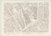
London VII.33 - OS London Town Plan
1 : 1056 Topographic maps Ordnance Survey Ordnance Survey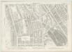
London VII.32 - OS London Town Plan
1 : 1056 Topographic maps Ordnance Survey Ordnance Survey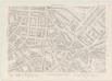
London VII.12 - OS London Town Plan
1 : 1056 Topographic maps Ordnance Survey Ordnance Survey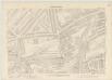
London VII.13 - OS London Town Plan
1 : 1056 Topographic maps Ordnance Survey Ordnance Survey
Insurance Plan of London Vol. xi: sheet 404-1
1 : 480 This detailed 1891 plan of London is one of a series of forty seven sheets in an atlas originally produced to aid insurance companies in assessing fire risks. The building footprints, their use (commercial, residential, educational, etc.), the number of floors and the height of the building, as well as construction materials (and thus risk of burning) and special fire hazards (chemicals, kilns, ovens) were documented in order to estimate premiums. Names of individual businesses, property lines, and addresses were also often recorded. Together these maps provide a rich historical shapshot of the commercial activity and urban landscape of towns and cities at the time. The British Library holds a comprehensive collection of fire insurance plans produced by the London-based firm Charles E. Goad Ltd. dating back to 1885. These plans were made for most important towns and cities of the British Isles at the scales of 1:480 (1 inch to 40 feet), as well as many foreign towns at 1:600 (1 inch to 50 feet). Chas E Goad Limited Chas E Goad Limited
Insurance Plan of London Vol. xi: sheet 407
1 : 480 This detailed 1891 plan of London is one of a series of forty seven sheets in an atlas originally produced to aid insurance companies in assessing fire risks. The building footprints, their use (commercial, residential, educational, etc.), the number of floors and the height of the building, as well as construction materials (and thus risk of burning) and special fire hazards (chemicals, kilns, ovens) were documented in order to estimate premiums. Names of individual businesses, property lines, and addresses were also often recorded. Together these maps provide a rich historical shapshot of the commercial activity and urban landscape of towns and cities at the time. The British Library holds a comprehensive collection of fire insurance plans produced by the London-based firm Charles E. Goad Ltd. dating back to 1885. These plans were made for most important towns and cities of the British Isles at the scales of 1:480 (1 inch to 40 feet), as well as many foreign towns at 1:600 (1 inch to 50 feet). Chas E Goad Limited Chas E Goad Limited
A Plan of Ground to be let at Somers Place in the Parish of St. Pancras.

Insurance Plan of London Vol. xi: sheet 405
1 : 480 This detailed 1891 plan of London is one of a series of forty seven sheets in an atlas originally produced to aid insurance companies in assessing fire risks. The building footprints, their use (commercial, residential, educational, etc.), the number of floors and the height of the building, as well as construction materials (and thus risk of burning) and special fire hazards (chemicals, kilns, ovens) were documented in order to estimate premiums. Names of individual businesses, property lines, and addresses were also often recorded. Together these maps provide a rich historical shapshot of the commercial activity and urban landscape of towns and cities at the time. The British Library holds a comprehensive collection of fire insurance plans produced by the London-based firm Charles E. Goad Ltd. dating back to 1885. These plans were made for most important towns and cities of the British Isles at the scales of 1:480 (1 inch to 40 feet), as well as many foreign towns at 1:600 (1 inch to 50 feet). Chas E Goad Limited Chas E Goad Limited
Insurance Plan of London Vol. xi: sheet 408
1 : 480 This detailed 1891 plan of London is one of a series of forty seven sheets in an atlas originally produced to aid insurance companies in assessing fire risks. The building footprints, their use (commercial, residential, educational, etc.), the number of floors and the height of the building, as well as construction materials (and thus risk of burning) and special fire hazards (chemicals, kilns, ovens) were documented in order to estimate premiums. Names of individual businesses, property lines, and addresses were also often recorded. Together these maps provide a rich historical shapshot of the commercial activity and urban landscape of towns and cities at the time. The British Library holds a comprehensive collection of fire insurance plans produced by the London-based firm Charles E. Goad Ltd. dating back to 1885. These plans were made for most important towns and cities of the British Isles at the scales of 1:480 (1 inch to 40 feet), as well as many foreign towns at 1:600 (1 inch to 50 feet). Chas E Goad Limited Chas E Goad Limited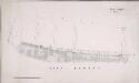
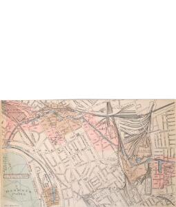
THE FIG LANE ESTATE
1 : 480 This plan of a Camden Town estate features title at top right and scale bar at bottom left. The plan shows the properties in the Fig Lane Estate in grey with the sewage canal running behind them in blue. Salway, T.
Insurance Plan of London Vol. xi: sheet 399-1
1 : 480 This detailed 1891 plan of London is one of a series of forty seven sheets in an atlas originally produced to aid insurance companies in assessing fire risks. The building footprints, their use (commercial, residential, educational, etc.), the number of floors and the height of the building, as well as construction materials (and thus risk of burning) and special fire hazards (chemicals, kilns, ovens) were documented in order to estimate premiums. Names of individual businesses, property lines, and addresses were also often recorded. Together these maps provide a rich historical shapshot of the commercial activity and urban landscape of towns and cities at the time. The British Library holds a comprehensive collection of fire insurance plans produced by the London-based firm Charles E. Goad Ltd. dating back to 1885. These plans were made for most important towns and cities of the British Isles at the scales of 1:480 (1 inch to 40 feet), as well as many foreign towns at 1:600 (1 inch to 50 feet). Chas E Goad Limited Chas E Goad Limited
Insurance Plan of London Vol. xi: sheet 404-2
1 : 480 This detailed 1891 plan of London is one of a series of forty seven sheets in an atlas originally produced to aid insurance companies in assessing fire risks. The building footprints, their use (commercial, residential, educational, etc.), the number of floors and the height of the building, as well as construction materials (and thus risk of burning) and special fire hazards (chemicals, kilns, ovens) were documented in order to estimate premiums. Names of individual businesses, property lines, and addresses were also often recorded. Together these maps provide a rich historical shapshot of the commercial activity and urban landscape of towns and cities at the time. The British Library holds a comprehensive collection of fire insurance plans produced by the London-based firm Charles E. Goad Ltd. dating back to 1885. These plans were made for most important towns and cities of the British Isles at the scales of 1:480 (1 inch to 40 feet), as well as many foreign towns at 1:600 (1 inch to 50 feet). Chas E Goad Limited Chas E Goad Limited
Insurance Plan of London Vol. xi: sheet 402-2
1 : 480 This detailed 1891 plan of London is one of a series of forty seven sheets in an atlas originally produced to aid insurance companies in assessing fire risks. The building footprints, their use (commercial, residential, educational, etc.), the number of floors and the height of the building, as well as construction materials (and thus risk of burning) and special fire hazards (chemicals, kilns, ovens) were documented in order to estimate premiums. Names of individual businesses, property lines, and addresses were also often recorded. Together these maps provide a rich historical shapshot of the commercial activity and urban landscape of towns and cities at the time. The British Library holds a comprehensive collection of fire insurance plans produced by the London-based firm Charles E. Goad Ltd. dating back to 1885. These plans were made for most important towns and cities of the British Isles at the scales of 1:480 (1 inch to 40 feet), as well as many foreign towns at 1:600 (1 inch to 50 feet). Chas E Goad Limited Chas E Goad Limited
Insurance Plan of London Vol. xi: sheet 398-2
1 : 480 This detailed 1891 plan of London is one of a series of forty seven sheets in an atlas originally produced to aid insurance companies in assessing fire risks. The building footprints, their use (commercial, residential, educational, etc.), the number of floors and the height of the building, as well as construction materials (and thus risk of burning) and special fire hazards (chemicals, kilns, ovens) were documented in order to estimate premiums. Names of individual businesses, property lines, and addresses were also often recorded. Together these maps provide a rich historical shapshot of the commercial activity and urban landscape of towns and cities at the time. The British Library holds a comprehensive collection of fire insurance plans produced by the London-based firm Charles E. Goad Ltd. dating back to 1885. These plans were made for most important towns and cities of the British Isles at the scales of 1:480 (1 inch to 40 feet), as well as many foreign towns at 1:600 (1 inch to 50 feet). Chas E Goad Limited Chas E Goad Limited
Insurance Plan of London Vol. xi: sheet 400-2
1 : 480 This detailed 1891 plan of London is one of a series of forty seven sheets in an atlas originally produced to aid insurance companies in assessing fire risks. The building footprints, their use (commercial, residential, educational, etc.), the number of floors and the height of the building, as well as construction materials (and thus risk of burning) and special fire hazards (chemicals, kilns, ovens) were documented in order to estimate premiums. Names of individual businesses, property lines, and addresses were also often recorded. Together these maps provide a rich historical shapshot of the commercial activity and urban landscape of towns and cities at the time. The British Library holds a comprehensive collection of fire insurance plans produced by the London-based firm Charles E. Goad Ltd. dating back to 1885. These plans were made for most important towns and cities of the British Isles at the scales of 1:480 (1 inch to 40 feet), as well as many foreign towns at 1:600 (1 inch to 50 feet). Chas E Goad Limited Chas E Goad Limited
Insurance Plan of London North North West District Vol. D: sheet 8-2
1 : 480 This detailed 1892 plan of London is one of a series of eight sheets in an atlas originally produced to aid insurance companies in assessing fire risks. The building footprints, their use (commercial, residential, educational, etc.), the number of floors and the height of the building, as well as construction materials (and thus risk of burning) and special fire hazards (chemicals, kilns, ovens) were documented in order to estimate premiums. Names of individual businesses, property lines, and addresses were also often recorded. Together these maps provide a rich historical shapshot of the commercial activity and urban landscape of towns and cities at the time. The British Library holds a comprehensive collection of fire insurance plans produced by the London-based firm Charles E. Goad Ltd. dating back to 1885. These plans were made for most important towns and cities of the British Isles at the scales of 1:480 (1 inch to 40 feet), as well as many foreign towns at 1:600 (1 inch to 50 feet). Chas E Goad Limited Chas E Goad Limited
SKETCH PLAN AS LAID OUT FOR BUILDING HOUSES OF THE SECOND AND THIRD RATE OF BUILDINGS AT BATTLE BRIDGE, THE PROPERTY OF ROBERT Mc WILLIAM AND THE TRUSTEES UNDER HIS MARRIAGE SETTLEMENT.
Plan for proposed new buildings at Battle Bridge, the site where King's Cross railway station now stands. Standidge & Lemon
Insurance Plan of London Vol. xi: sheet 398-1
1 : 480 This detailed 1891 plan of London is one of a series of forty seven sheets in an atlas originally produced to aid insurance companies in assessing fire risks. The building footprints, their use (commercial, residential, educational, etc.), the number of floors and the height of the building, as well as construction materials (and thus risk of burning) and special fire hazards (chemicals, kilns, ovens) were documented in order to estimate premiums. Names of individual businesses, property lines, and addresses were also often recorded. Together these maps provide a rich historical shapshot of the commercial activity and urban landscape of towns and cities at the time. The British Library holds a comprehensive collection of fire insurance plans produced by the London-based firm Charles E. Goad Ltd. dating back to 1885. These plans were made for most important towns and cities of the British Isles at the scales of 1:480 (1 inch to 40 feet), as well as many foreign towns at 1:600 (1 inch to 50 feet). Chas E Goad Limited Chas E Goad Limited
Insurance Plan of London North North West District Vol. D: sheet 9
1 : 480 This detailed 1892 plan of London is one of a series of eight sheets in an atlas originally produced to aid insurance companies in assessing fire risks. The building footprints, their use (commercial, residential, educational, etc.), the number of floors and the height of the building, as well as construction materials (and thus risk of burning) and special fire hazards (chemicals, kilns, ovens) were documented in order to estimate premiums. Names of individual businesses, property lines, and addresses were also often recorded. Together these maps provide a rich historical shapshot of the commercial activity and urban landscape of towns and cities at the time. The British Library holds a comprehensive collection of fire insurance plans produced by the London-based firm Charles E. Goad Ltd. dating back to 1885. These plans were made for most important towns and cities of the British Isles at the scales of 1:480 (1 inch to 40 feet), as well as many foreign towns at 1:600 (1 inch to 50 feet). Chas E Goad Limited Chas E Goad Limited
Insurance Plan of London North West District Vol. C: sheet 23-3
1 : 480 This detailed 1900 plan of London is one of a series of thirteen sheets in an atlas originally produced to aid insurance companies in assessing fire risks. The building footprints, their use (commercial, residential, educational, etc.), the number of floors and the height of the building, as well as construction materials (and thus risk of burning) and special fire hazards (chemicals, kilns, ovens) were documented in order to estimate premiums. Names of individual businesses, property lines, and addresses were also often recorded. Together these maps provide a rich historical shapshot of the commercial activity and urban landscape of towns and cities at the time. The British Library holds a comprehensive collection of fire insurance plans produced by the London-based firm Charles E. Goad Ltd. dating back to 1885. These plans were made for most important towns and cities of the British Isles at the scales of 1:480 (1 inch to 40 feet), as well as many foreign towns at 1:600 (1 inch to 50 feet). Chas E Goad Limited Chas E Goad Limited
London VII.NW - OS Six-Inch Map
1 : 10560 Topographic maps Ordnance Survey Ordnance Survey
London (1915- Numbered sheets) V.5 (includes: St Marylebone; St Pancras) - 25 Inch Map
1 : 2500 Topographic maps Ordnance Survey Ordnance Survey